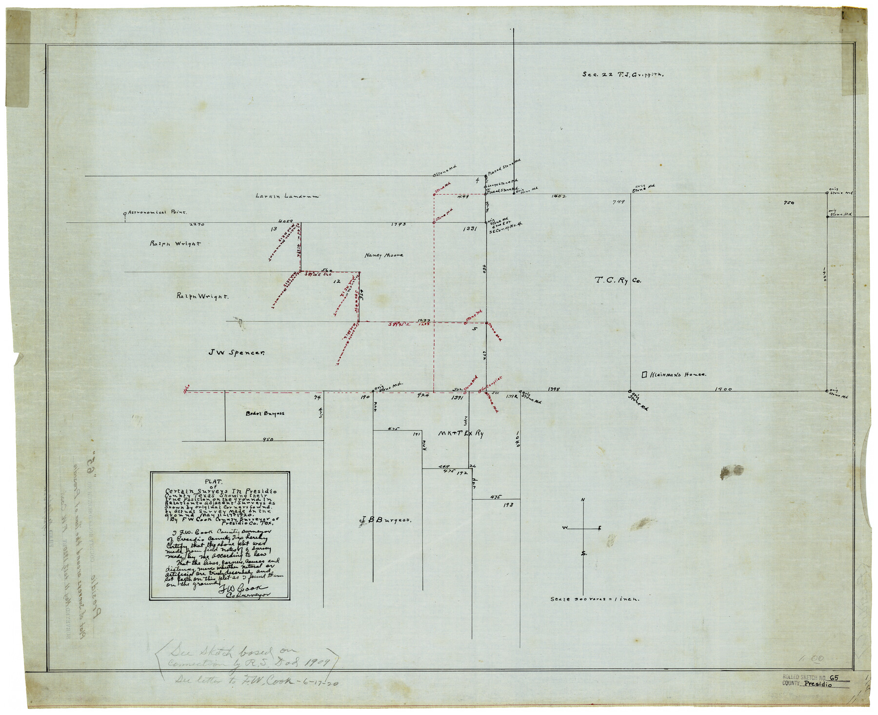
Presidio County Rolled Sketch 65
Plat of certain surveys in Presidio County, Texas showing their true position on the ground in relation to adjacent surveys as shown by original corners found by actual survey made on the ground
-
Map/Doc
7356
-
Collection
General Map Collection
-
Object Dates
5/17/1920 (Survey Date)
-
People and Organizations
F.W. Cook (Surveyor/Engineer)
-
Counties
Presidio
-
Subjects
Surveying Rolled Sketch
-
Height x Width
23.1 x 28.3 inches
58.7 x 71.9 cm
-
Medium
linen, manuscript
Part of: General Map Collection
Wichita County Sketch File H

Print $4.00
- Digital $50.00
Wichita County Sketch File H
1884
Size 12.8 x 8.2 inches
Map/Doc 40089
[Map of Grayson County]
![4551, [Map of Grayson County], General Map Collection](https://historictexasmaps.com/wmedia_w700/maps/4551-1.tif.jpg)
Print $20.00
- Digital $50.00
[Map of Grayson County]
1848
Size 25.6 x 20.0 inches
Map/Doc 4551

[Beaumont, Sour Lake and Western Ry. Right of Way and Alignment - Frisco]
![64106, [Beaumont, Sour Lake and Western Ry. Right of Way and Alignment - Frisco], General Map Collection](https://historictexasmaps.com/wmedia_w700/maps/64106.tif.jpg)
Print $20.00
- Digital $50.00
[Beaumont, Sour Lake and Western Ry. Right of Way and Alignment - Frisco]
1910
Size 19.9 x 45.9 inches
Map/Doc 64106
Pecos County Rolled Sketch 43

Print $20.00
- Digital $50.00
Pecos County Rolled Sketch 43
1912
Size 25.4 x 34.8 inches
Map/Doc 7221
Flight Mission No. BRE-1P, Frame 129, Nueces County

Print $20.00
- Digital $50.00
Flight Mission No. BRE-1P, Frame 129, Nueces County
1956
Size 18.5 x 22.6 inches
Map/Doc 86695
Milam County Boundary File 6a

Print $20.00
- Digital $50.00
Milam County Boundary File 6a
Size 9.5 x 29.0 inches
Map/Doc 57248
Map representing the surveys made in Bexar County

Print $40.00
- Digital $50.00
Map representing the surveys made in Bexar County
1839
Size 75.7 x 35.1 inches
Map/Doc 93365
Comal County Working Sketch Graphic Index

Print $20.00
- Digital $50.00
Comal County Working Sketch Graphic Index
1947
Size 41.8 x 35.9 inches
Map/Doc 76501
Val Verde County Rolled Sketch JR

Print $20.00
- Digital $50.00
Val Verde County Rolled Sketch JR
1938
Size 35.9 x 31.1 inches
Map/Doc 10080
Township 14 South Range 15 West of the Louisiana Meridian, Louisiana

Print $20.00
- Digital $50.00
Township 14 South Range 15 West of the Louisiana Meridian, Louisiana
1875
Size 19.6 x 24.6 inches
Map/Doc 65859
Harris County Historic Topographic 35

Print $20.00
- Digital $50.00
Harris County Historic Topographic 35
1915
Size 19.6 x 23.6 inches
Map/Doc 65846
You may also like
Hays County Sketch File 19a

Print $39.00
- Digital $50.00
Hays County Sketch File 19a
1894
Size 19.4 x 28.6 inches
Map/Doc 11749
Nueces County Rolled Sketch 30

Print $40.00
- Digital $50.00
Nueces County Rolled Sketch 30
1952
Size 60.3 x 38.9 inches
Map/Doc 9598
Flight Mission No. CLL-1N, Frame 191, Willacy County

Print $20.00
- Digital $50.00
Flight Mission No. CLL-1N, Frame 191, Willacy County
1954
Size 18.3 x 22.0 inches
Map/Doc 87061
Calhoun County Boundary File 3

Print $8.00
- Digital $50.00
Calhoun County Boundary File 3
Size 11.3 x 8.7 inches
Map/Doc 50975
Knox County Working Sketch 17

Print $20.00
- Digital $50.00
Knox County Working Sketch 17
1967
Size 36.8 x 27.1 inches
Map/Doc 70259
Uvalde County Working Sketch 51

Print $20.00
- Digital $50.00
Uvalde County Working Sketch 51
1981
Size 34.7 x 37.7 inches
Map/Doc 72121
Duval County Rolled Sketch 48

Print $20.00
- Digital $50.00
Duval County Rolled Sketch 48
Size 21.8 x 18.5 inches
Map/Doc 5762
Harris County Working Sketch 107

Print $20.00
- Digital $50.00
Harris County Working Sketch 107
1981
Size 46.0 x 28.1 inches
Map/Doc 65999
Rusk County Working Sketch 26

Print $20.00
- Digital $50.00
Rusk County Working Sketch 26
1938
Size 42.8 x 36.8 inches
Map/Doc 63662
Dallam County Sketch File 2

Print $260.00
- Digital $50.00
Dallam County Sketch File 2
1886
Size 29.9 x 17.4 inches
Map/Doc 11278
Map of Young County

Print $20.00
- Digital $50.00
Map of Young County
Size 16.9 x 19.7 inches
Map/Doc 92108
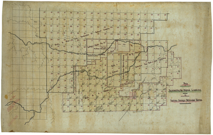
Map Representing the Original Locations of Various Surveys Deliniated Thereon
Print $40.00
- Digital $50.00
Map Representing the Original Locations of Various Surveys Deliniated Thereon
1890
Size 40.8 x 62.0 inches
Map/Doc 469