Hays County Sketch File 19a
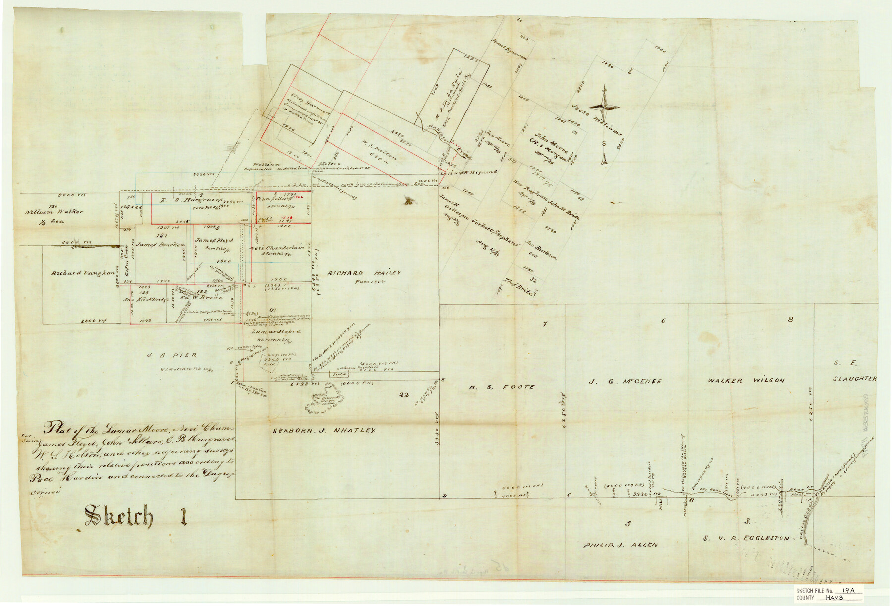
Plat of the Lamar Moore, Levi Chamberlain, James Floyd, John Sellars, E. B. Hargraves, W. L. Holton, and other adjoining surveys showing their relative positions according to Pace Hardin and connected to the "Dug up corner"
-
Map/Doc
11749
-
Collection
General Map Collection
-
Object Dates
1894/5/10 (Creation Date)
1892/6/7 (Creation Date)
-
People and Organizations
John E. Wallace (Surveyor/Engineer)
Jno. E. Campbell (Surveyor/Engineer)
-
Counties
Hays Travis
-
Subjects
Surveying Sketch File
-
Height x Width
19.4 x 28.6 inches
49.3 x 72.6 cm
-
Medium
multi-page, multi-format
-
Features
Slaughter Creek
Johnson Institute
Onion Creek
Dry Bear Creek
Bear Creek
Little Bear Creek
Part of: General Map Collection
Nolan County Boundary File 1

Print $60.00
- Digital $50.00
Nolan County Boundary File 1
Size 8.8 x 3.9 inches
Map/Doc 57617
Trinity County Sketch File 20

Print $20.00
- Digital $50.00
Trinity County Sketch File 20
Size 21.3 x 27.9 inches
Map/Doc 12485
Kinney County Sketch File E

Print $10.00
- Digital $50.00
Kinney County Sketch File E
1885
Size 10.7 x 8.1 inches
Map/Doc 29124
Dallam County Sketch File 2

Print $260.00
- Digital $50.00
Dallam County Sketch File 2
1886
Size 29.9 x 17.4 inches
Map/Doc 11278
Maps of Gulf Intracoastal Waterway, Texas - Sabine River to the Rio Grande and connecting waterways including ship channels

Print $20.00
- Digital $50.00
Maps of Gulf Intracoastal Waterway, Texas - Sabine River to the Rio Grande and connecting waterways including ship channels
1966
Size 14.5 x 22.2 inches
Map/Doc 61969
Trinity County Sketch File 6

Print $6.00
- Digital $50.00
Trinity County Sketch File 6
Size 16.2 x 10.2 inches
Map/Doc 38508
Menard County Working Sketch 33

Print $20.00
- Digital $50.00
Menard County Working Sketch 33
1989
Size 27.2 x 25.2 inches
Map/Doc 70980
Padre Island National Seashore, Texas - Dependent Resurvey

Print $4.00
- Digital $50.00
Padre Island National Seashore, Texas - Dependent Resurvey
2001
Size 18.2 x 24.3 inches
Map/Doc 60552
Flight Mission No. DIX-7P, Frame 16, Aransas County

Print $20.00
- Digital $50.00
Flight Mission No. DIX-7P, Frame 16, Aransas County
1956
Size 18.9 x 22.5 inches
Map/Doc 83868
Bexar County Rolled Sketch 3

Print $20.00
- Digital $50.00
Bexar County Rolled Sketch 3
1873
Size 25.5 x 18.0 inches
Map/Doc 5136
Baylor County Working Sketch 1

Print $20.00
- Digital $50.00
Baylor County Working Sketch 1
1912
Size 19.9 x 12.7 inches
Map/Doc 67286
Jack County Working Sketch 6

Print $20.00
- Digital $50.00
Jack County Working Sketch 6
1952
Size 29.1 x 24.3 inches
Map/Doc 66432
You may also like

Sabine County Sketch File 6b

Print $4.00
Sabine County Sketch File 6b
1879
Size 8.1 x 9.0 inches
Map/Doc 35617
Childress County Sketch File 21

Print $10.00
- Digital $50.00
Childress County Sketch File 21
1896
Size 9.1 x 5.8 inches
Map/Doc 18298
Harris County Rolled Sketch GC

Print $40.00
- Digital $50.00
Harris County Rolled Sketch GC
1917
Size 42.1 x 52.4 inches
Map/Doc 9115
Hutchinson County Sketch File 4a

Print $7.00
- Digital $50.00
Hutchinson County Sketch File 4a
Size 25.9 x 43.8 inches
Map/Doc 10625
Bexar County Sketch File 55

Print $20.00
- Digital $50.00
Bexar County Sketch File 55
1838
Size 13.3 x 8.3 inches
Map/Doc 14560
Plano General de la Ciudad de Mexico. Levantado Por el Teniente Coronel Don Diego Garcia Conde en el Año de 1793. Aumentado y corregido en lo mas notable Por el Teniente Coronel retirado, Don Rafael Maria Calvo En el de 1830

Print $20.00
- Digital $50.00
Plano General de la Ciudad de Mexico. Levantado Por el Teniente Coronel Don Diego Garcia Conde en el Año de 1793. Aumentado y corregido en lo mas notable Por el Teniente Coronel retirado, Don Rafael Maria Calvo En el de 1830
1793
Size 19.7 x 21.8 inches
Map/Doc 95354

Real County Working Sketch 63

Print $20.00
- Digital $50.00
Real County Working Sketch 63
1967
Size 28.8 x 32.3 inches
Map/Doc 71955
[I. & G. N. Block 1, sections 64, 65, 67-71 and 545 along river]
![91605, [I. & G. N. Block 1, sections 64, 65, 67-71 and 545 along river], Twichell Survey Records](https://historictexasmaps.com/wmedia_w700/maps/91605-1.tif.jpg)
Print $2.00
- Digital $50.00
[I. & G. N. Block 1, sections 64, 65, 67-71 and 545 along river]
Size 9.1 x 14.7 inches
Map/Doc 91605
Hays County Boundary File 4

Print $4.00
- Digital $50.00
Hays County Boundary File 4
Size 5.1 x 8.9 inches
Map/Doc 54607
Current Miscellaneous File 102

Print $611.00
- Digital $50.00
Current Miscellaneous File 102
Size 11.5 x 7.1 inches
Map/Doc 74379