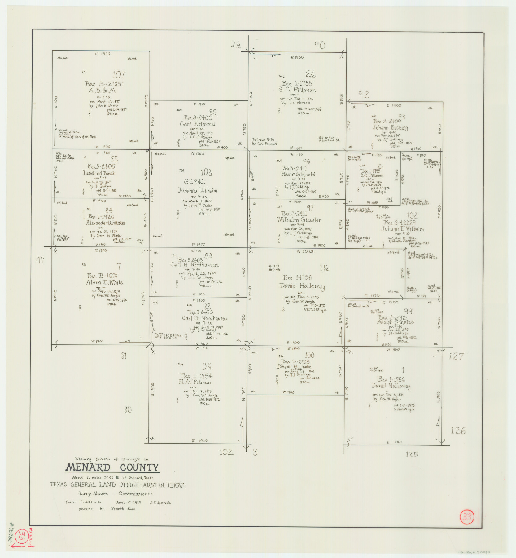
Menard County Working Sketch 33
-
Map/Doc
70980
-
Collection
General Map Collection
-
Object Dates
4/17/1989 (Creation Date)
-
People and Organizations
Joan Kilpatrick (Draftsman)
-
Counties
Menard
-
Subjects
Surveying Working Sketch
-
Height x Width
27.2 x 25.2 inches
69.1 x 64.0 cm
-
Scale
1" = 400 varas
Part of: General Map Collection
Pecos County Sketch File 45

Print $20.00
- Digital $50.00
Pecos County Sketch File 45
Size 13.8 x 21.7 inches
Map/Doc 12179
[Maps of surveys in Reeves & Culberson Cos]
![61142, [Maps of surveys in Reeves & Culberson Cos], General Map Collection](https://historictexasmaps.com/wmedia_w700/maps/61142.tif.jpg)
Print $20.00
- Digital $50.00
[Maps of surveys in Reeves & Culberson Cos]
1937
Size 30.6 x 24.8 inches
Map/Doc 61142
Coleman County Sketch File 37

Print $4.00
- Digital $50.00
Coleman County Sketch File 37
1891
Size 11.1 x 8.4 inches
Map/Doc 18742
Pecos County Working Sketch 40

Print $20.00
- Digital $50.00
Pecos County Working Sketch 40
1941
Size 29.9 x 39.7 inches
Map/Doc 71512
Robertson County Working Sketch 11

Print $20.00
- Digital $50.00
Robertson County Working Sketch 11
1984
Size 20.2 x 21.4 inches
Map/Doc 63584
Edwards County Working Sketch 70

Print $20.00
- Digital $50.00
Edwards County Working Sketch 70
1957
Size 22.5 x 22.4 inches
Map/Doc 68946
Presidio County Sketch File 105

Print $20.00
- Digital $50.00
Presidio County Sketch File 105
Size 15.6 x 42.6 inches
Map/Doc 11726
Starr County Sketch File 32B

Print $20.00
- Digital $50.00
Starr County Sketch File 32B
1938
Size 19.9 x 21.5 inches
Map/Doc 12336
Leon County Rolled Sketch 21

Print $20.00
- Digital $50.00
Leon County Rolled Sketch 21
Size 33.5 x 24.3 inches
Map/Doc 75971
Trinity County Working Sketch 9

Print $20.00
- Digital $50.00
Trinity County Working Sketch 9
1947
Size 23.5 x 28.1 inches
Map/Doc 69458
Brazoria County Sketch File 13

Print $40.00
- Digital $50.00
Brazoria County Sketch File 13
Size 23.8 x 23.0 inches
Map/Doc 10950
Pecos County Rolled Sketch 168

Print $40.00
- Digital $50.00
Pecos County Rolled Sketch 168
Size 73.5 x 44.7 inches
Map/Doc 9748
You may also like
Crockett County Working Sketch 76

Print $20.00
- Digital $50.00
Crockett County Working Sketch 76
1964
Size 34.3 x 36.3 inches
Map/Doc 68409
Map of the Missouri, Kansas, & Texas Railway and Connecting Lines

Print $20.00
- Digital $50.00
Map of the Missouri, Kansas, & Texas Railway and Connecting Lines
Size 11.2 x 17.2 inches
Map/Doc 96599
Tom Green County Rolled Sketch 18

Print $20.00
- Digital $50.00
Tom Green County Rolled Sketch 18
Size 15.7 x 23.8 inches
Map/Doc 8001
[Townships 1 & 2, Blocks 56, 57]
![92927, [Townships 1 & 2, Blocks 56, 57], Twichell Survey Records](https://historictexasmaps.com/wmedia_w700/maps/92927-1.tif.jpg)
Print $20.00
- Digital $50.00
[Townships 1 & 2, Blocks 56, 57]
Size 19.7 x 22.8 inches
Map/Doc 92927
Uvalde County Working Sketch 48

Print $20.00
- Digital $50.00
Uvalde County Working Sketch 48
1980
Size 15.6 x 17.9 inches
Map/Doc 72118
Bexar County Sketch File 58

Print $4.00
- Digital $50.00
Bexar County Sketch File 58
1847
Size 10.4 x 8.3 inches
Map/Doc 14572
Presidio County Rolled Sketch 130

Print $40.00
- Digital $50.00
Presidio County Rolled Sketch 130
1993
Size 33.6 x 49.1 inches
Map/Doc 9800
PSL Field Notes for Blocks 26 and 27 in Winkler County

PSL Field Notes for Blocks 26 and 27 in Winkler County
Map/Doc 81678
Reyno de la Nueva Espana a Principios del Siglo XIX

Print $20.00
- Digital $50.00
Reyno de la Nueva Espana a Principios del Siglo XIX
Size 26.0 x 34.3 inches
Map/Doc 96807
Gaines County Working Sketch 12

Print $20.00
- Digital $50.00
Gaines County Working Sketch 12
1954
Size 27.1 x 37.0 inches
Map/Doc 69312
Hudspeth County Rolled Sketch 69

Print $20.00
- Digital $50.00
Hudspeth County Rolled Sketch 69
1973
Size 12.3 x 19.8 inches
Map/Doc 7719
San Luis Pass to East Matagorda Bay

Print $40.00
- Digital $50.00
San Luis Pass to East Matagorda Bay
1982
Size 35.6 x 49.3 inches
Map/Doc 69970