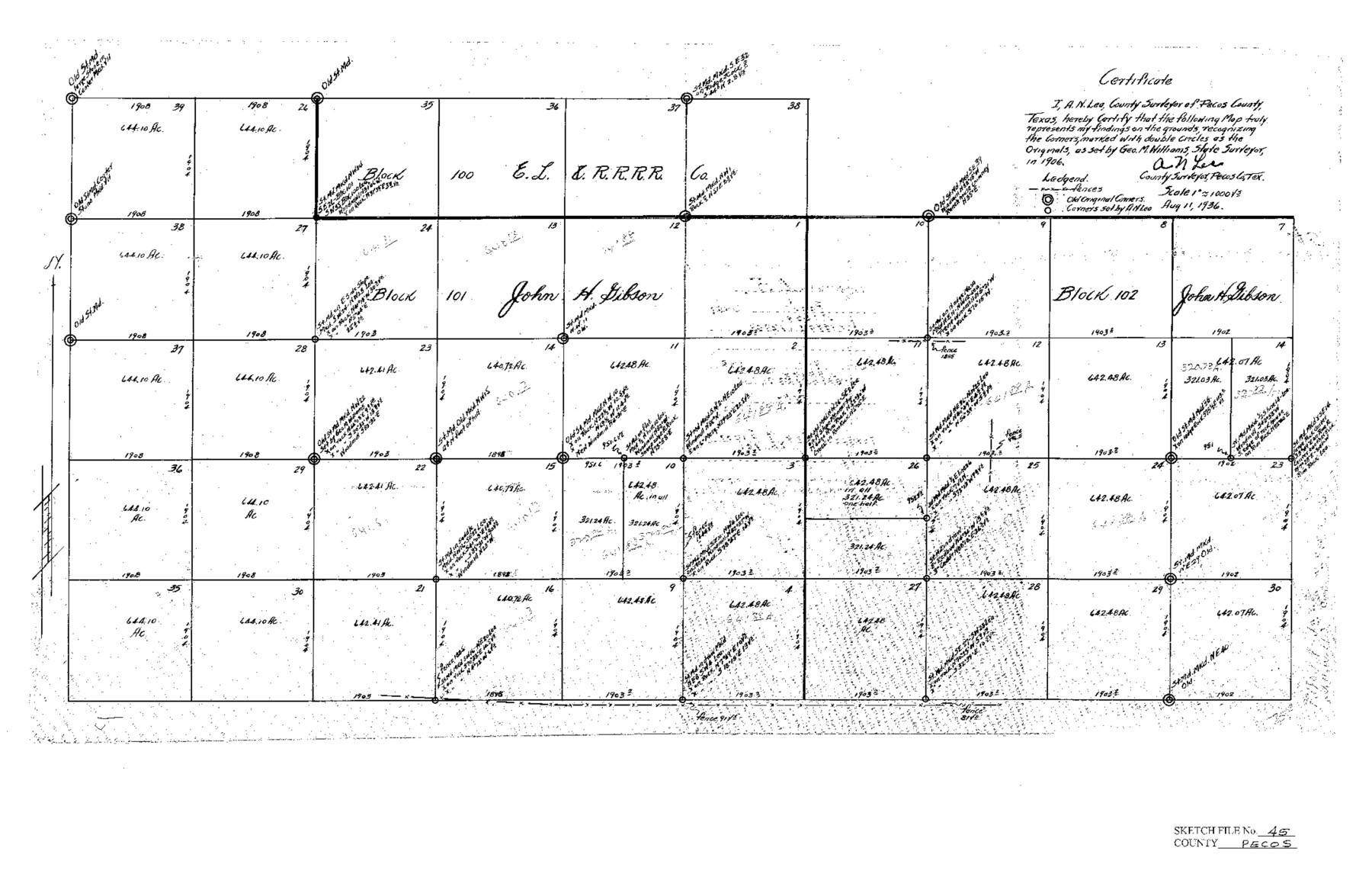
Pecos County Sketch File 45
[John H. Gibson Block 101 and Adjacent Blocks, Pecos County, Texas]
-
Map/Doc
12179
-
Collection
General Map Collection
-
Object Dates
1936/9/1 (File Date)
1906 (Survey Date)
1936/8/11 (Survey Date)
-
People and Organizations
A.N. Lea (Surveyor/Engineer)
George M. Williams (Surveyor/Engineer)
-
Counties
Pecos
-
Subjects
Surveying Sketch File
-
Height x Width
13.8 x 21.7 inches
35.1 x 55.1 cm
-
Medium
paper, print
-
Scale
1" = 1000 varas
Part of: General Map Collection
Brazoria County NRC Article 33.136 Sketch 2

Print $20.00
- Digital $50.00
Brazoria County NRC Article 33.136 Sketch 2
2002
Size 40.6 x 29.7 inches
Map/Doc 77038
Morris County Rolled Sketch 2A

Print $20.00
- Digital $50.00
Morris County Rolled Sketch 2A
Size 22.7 x 17.7 inches
Map/Doc 10227
Young County Working Sketch 14

Print $20.00
- Digital $50.00
Young County Working Sketch 14
1944
Size 15.3 x 16.0 inches
Map/Doc 62037
Crane County Sketch File 24

Print $20.00
- Digital $50.00
Crane County Sketch File 24
Size 23.0 x 17.0 inches
Map/Doc 11212
Live Oak County Sketch File A

Print $2.00
- Digital $50.00
Live Oak County Sketch File A
Size 7.9 x 4.7 inches
Map/Doc 30250
Cottle County Working Sketch 7

Print $20.00
- Digital $50.00
Cottle County Working Sketch 7
1916
Size 28.4 x 30.4 inches
Map/Doc 68317
Newton County Sketch File 15

Print $20.00
- Digital $50.00
Newton County Sketch File 15
1878
Size 29.1 x 16.8 inches
Map/Doc 42156
Map of Caldwell County

Print $20.00
- Digital $50.00
Map of Caldwell County
1871
Size 16.9 x 19.8 inches
Map/Doc 4590
Hemphill County

Print $20.00
- Digital $50.00
Hemphill County
1888
Size 23.9 x 18.3 inches
Map/Doc 3653
Williamson County

Print $20.00
- Digital $50.00
Williamson County
1919
Size 22.5 x 29.8 inches
Map/Doc 4643
La Salle County Sketch File 22

Print $4.00
- Digital $50.00
La Salle County Sketch File 22
1875
Size 12.8 x 8.2 inches
Map/Doc 29528
Brewster County Sketch File N-12

Print $4.00
- Digital $50.00
Brewster County Sketch File N-12
1933
Size 14.3 x 9.0 inches
Map/Doc 15623
You may also like
The Chief Justice County of Sabine. Lands in Conflict with Jasper and San Augustine Counties

Print $20.00
The Chief Justice County of Sabine. Lands in Conflict with Jasper and San Augustine Counties
2020
Size 20.0 x 21.7 inches
Map/Doc 96069
King County Survey

Print $20.00
- Digital $50.00
King County Survey
1916
Size 25.6 x 30.5 inches
Map/Doc 91021
Aransas County Rolled Sketch 30

Print $40.00
- Digital $50.00
Aransas County Rolled Sketch 30
1909
Size 15.9 x 61.6 inches
Map/Doc 8422
Webb County Sketch File 11a-1

Print $27.00
- Digital $50.00
Webb County Sketch File 11a-1
1884
Size 22.2 x 9.3 inches
Map/Doc 12626
Atascosa County Sketch File 11

Print $4.00
- Digital $50.00
Atascosa County Sketch File 11
1856
Size 10.8 x 8.6 inches
Map/Doc 13767
El Paso County Sketch File 23

Print $4.00
- Digital $50.00
El Paso County Sketch File 23
Size 11.3 x 8.6 inches
Map/Doc 22068
Wise County Sketch File 50

Print $20.00
- Digital $50.00
Wise County Sketch File 50
1895
Size 23.7 x 29.9 inches
Map/Doc 12703
Hunt County Rolled Sketch 5

Print $20.00
- Digital $50.00
Hunt County Rolled Sketch 5
1956
Size 22.9 x 23.0 inches
Map/Doc 6272
Gonzales County Sketch File 12

Print $4.00
- Digital $50.00
Gonzales County Sketch File 12
Size 10.8 x 8.7 inches
Map/Doc 24394
Right of Way Map Fort Worth & Denver City Railroad through Hardeman County

Print $40.00
- Digital $50.00
Right of Way Map Fort Worth & Denver City Railroad through Hardeman County
1885
Size 23.8 x 121.2 inches
Map/Doc 64424
Bailey County Sketch File 4

Print $8.00
- Digital $50.00
Bailey County Sketch File 4
1907
Size 14.2 x 8.7 inches
Map/Doc 13954
Frio County Rolled Sketch 25

Print $20.00
- Digital $50.00
Frio County Rolled Sketch 25
1965
Size 25.0 x 30.6 inches
Map/Doc 5925