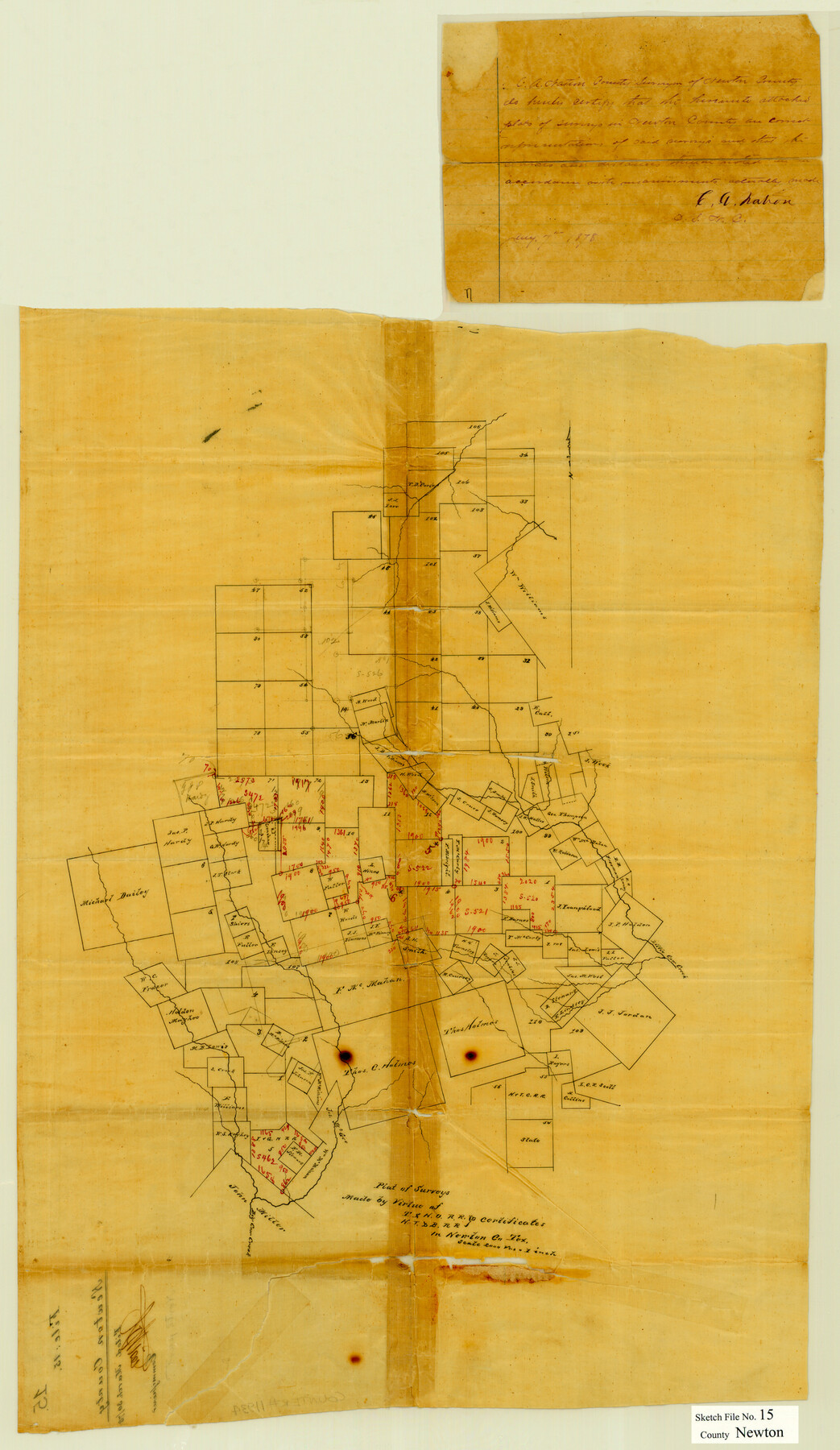
Newton County Sketch File 15
Plat of surveys made by virtue of T. & N. O. R.R. Co. & H. T. & B. R.R. Co. certificates in Newton Co., Tex.
-
Map/Doc
42156
-
Collection
General Map Collection
-
Object Dates
1/7/1878 (Creation Date)
3/30/1878 (File Date)
-
People and Organizations
C.A. Nation (Surveyor/Engineer)
-
Counties
Newton
-
Subjects
Surveying Sketch File
-
Height x Width
29.1 x 16.8 inches
73.9 x 42.7 cm
-
Medium
paper, manuscript
-
Scale
1" = 2000 varas
-
Features
Little Cow Creek
Big Cow Creek
Part of: General Map Collection
Comal County Working Sketch 2

Print $20.00
- Digital $50.00
Comal County Working Sketch 2
1940
Size 19.8 x 20.9 inches
Map/Doc 68168
Current Miscellaneous File 16

Print $20.00
- Digital $50.00
Current Miscellaneous File 16
1951
Size 10.7 x 8.2 inches
Map/Doc 73830
[Right of Way Map, Belton Branch of the M.K.&T. RR.]
![64715, [Right of Way Map, Belton Branch of the M.K.&T. RR.], General Map Collection](https://historictexasmaps.com/wmedia_w700/maps/64715-1.tif.jpg)
Print $2.00
- Digital $50.00
[Right of Way Map, Belton Branch of the M.K.&T. RR.]
1896
Size 11.1 x 8.3 inches
Map/Doc 64715
Burnet County Working Sketch 12

Print $20.00
- Digital $50.00
Burnet County Working Sketch 12
1976
Size 17.3 x 19.9 inches
Map/Doc 67855
Hudspeth County Rolled Sketch 47

Print $20.00
- Digital $50.00
Hudspeth County Rolled Sketch 47
1963
Size 22.2 x 25.9 inches
Map/Doc 6255
Shackelford County Boundary File 7a

Print $9.00
- Digital $50.00
Shackelford County Boundary File 7a
Size 14.9 x 9.4 inches
Map/Doc 58689
Duval County Sketch File 38

Print $64.00
- Digital $50.00
Duval County Sketch File 38
Size 38.2 x 19.5 inches
Map/Doc 10372
Wichita County Working Sketch 2

Print $20.00
- Digital $50.00
Wichita County Working Sketch 2
1913
Size 20.0 x 18.7 inches
Map/Doc 72511
Nacogdoches County Sketch File 20

Print $26.00
- Digital $50.00
Nacogdoches County Sketch File 20
Size 12.6 x 7.9 inches
Map/Doc 32275
Angelina County Working Sketch 19

Print $20.00
- Digital $50.00
Angelina County Working Sketch 19
1946
Size 35.8 x 39.3 inches
Map/Doc 67100
Map of Chicago, Rock Island & Texas Railroad

Print $40.00
- Digital $50.00
Map of Chicago, Rock Island & Texas Railroad
1892
Size 23.9 x 122.0 inches
Map/Doc 64442
Crockett County Rolled Sketch 88L

Print $20.00
- Digital $50.00
Crockett County Rolled Sketch 88L
1963
Size 19.0 x 24.6 inches
Map/Doc 5628
You may also like
Flight Mission No. BRA-7M, Frame 134, Jefferson County

Print $20.00
- Digital $50.00
Flight Mission No. BRA-7M, Frame 134, Jefferson County
1953
Size 18.6 x 22.5 inches
Map/Doc 85528

Eastland County Working Sketch 1

Print $3.00
- Digital $50.00
Eastland County Working Sketch 1
1907
Size 13.8 x 11.0 inches
Map/Doc 68782
Duval County Boundary File 3j

Print $12.00
- Digital $50.00
Duval County Boundary File 3j
Size 12.8 x 8.0 inches
Map/Doc 52753
Bexar County Sketch File X

Print $4.00
- Digital $50.00
Bexar County Sketch File X
1878
Size 8.0 x 10.5 inches
Map/Doc 14463

Borden County Boundary File 4

Print $2.00
- Digital $50.00
Borden County Boundary File 4
Size 13.3 x 8.3 inches
Map/Doc 50636
Palo Pinto County Sketch File 25a

Print $6.00
- Digital $50.00
Palo Pinto County Sketch File 25a
Size 11.0 x 11.4 inches
Map/Doc 33417
Potter County

Print $20.00
- Digital $50.00
Potter County
1960
Size 40.0 x 32.3 inches
Map/Doc 77397
Sutton County Sketch File C

Print $6.00
- Digital $50.00
Sutton County Sketch File C
1900
Size 14.0 x 8.6 inches
Map/Doc 37379
Dawson County Working Sketch 6

Print $20.00
- Digital $50.00
Dawson County Working Sketch 6
1939
Size 43.9 x 42.7 inches
Map/Doc 68550
DeWitt County Working Sketch 8

Print $20.00
- Digital $50.00
DeWitt County Working Sketch 8
1979
Size 35.7 x 41.9 inches
Map/Doc 68598