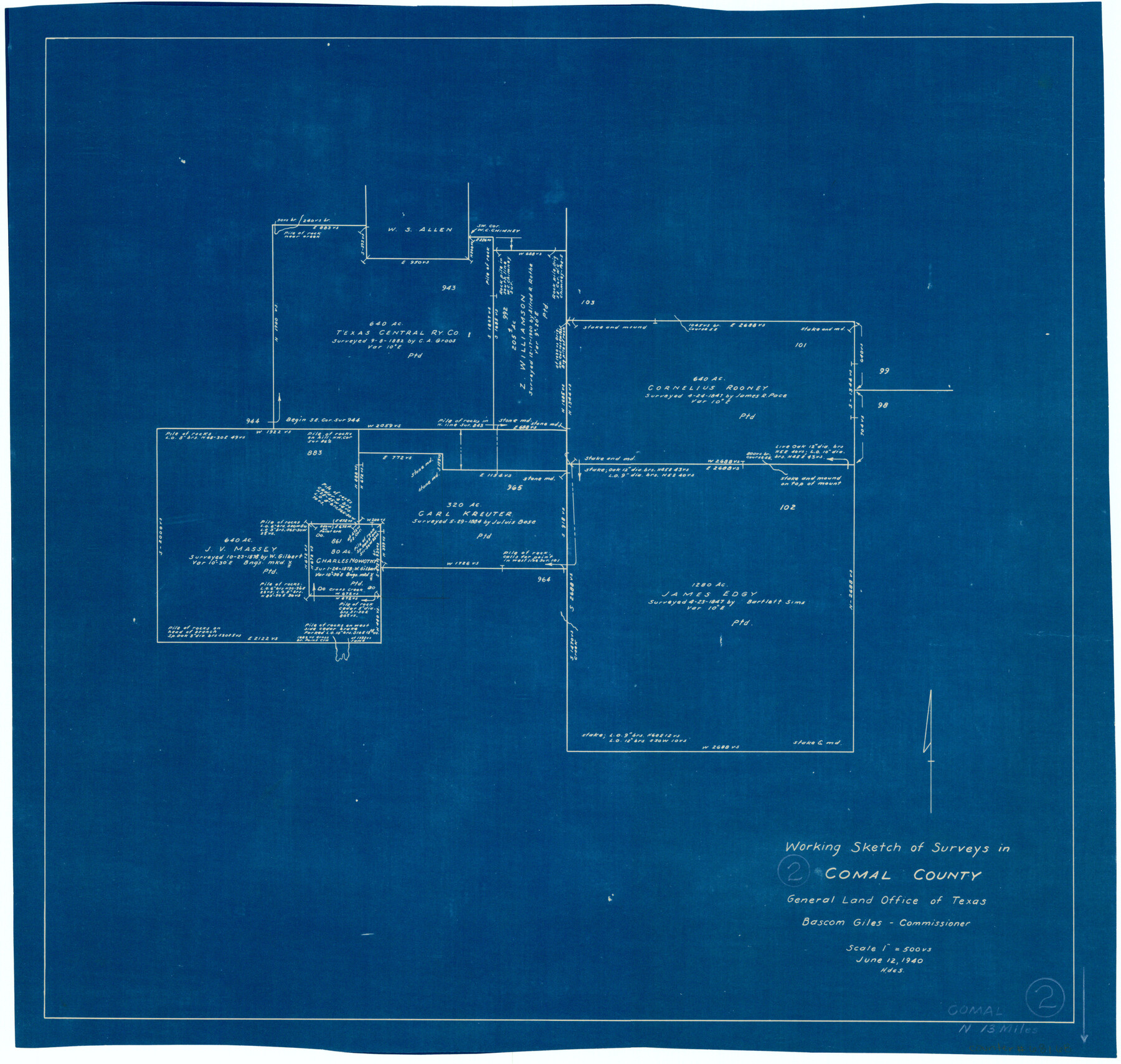
Comal County Working Sketch 2
-
Map/Doc
68168
-
Collection
General Map Collection
-
Object Dates
6/12/1940 (Creation Date)
-
People and Organizations
Herbert de Synek (Draftsman)
-
Counties
Comal
-
Subjects
Surveying Working Sketch
-
Height x Width
19.8 x 20.9 inches
50.3 x 53.1 cm
-
Scale
1" = 500 varas
Part of: General Map Collection
Live Oak County Rolled Sketch 4

Print $20.00
- Digital $50.00
Live Oak County Rolled Sketch 4
1946
Size 27.7 x 32.1 inches
Map/Doc 6633
Galveston Co.

Print $40.00
- Digital $50.00
Galveston Co.
1891
Size 37.5 x 53.8 inches
Map/Doc 66833
Brazoria County Rolled Sketch 18

Print $20.00
- Digital $50.00
Brazoria County Rolled Sketch 18
Size 28.0 x 22.5 inches
Map/Doc 5163
Midland County Rolled Sketch 3

Print $40.00
- Digital $50.00
Midland County Rolled Sketch 3
Size 71.7 x 24.4 inches
Map/Doc 9514
Presidio County Working Sketch 4

Print $20.00
- Digital $50.00
Presidio County Working Sketch 4
1915
Size 26.3 x 21.7 inches
Map/Doc 71678
Jones County Working Sketch 4

Print $20.00
- Digital $50.00
Jones County Working Sketch 4
1946
Size 35.5 x 20.6 inches
Map/Doc 66642
Garza County Working Sketch 13

Print $20.00
- Digital $50.00
Garza County Working Sketch 13
1956
Size 19.0 x 12.7 inches
Map/Doc 63160
Bowie County Sketch File 7d

Print $40.00
- Digital $50.00
Bowie County Sketch File 7d
1927
Size 16.2 x 13.7 inches
Map/Doc 10944
Hudspeth County Working Sketch 57

Print $20.00
- Digital $50.00
Hudspeth County Working Sketch 57
1992
Size 9.6 x 26.5 inches
Map/Doc 66342
Hardin County Sketch File 20

Print $6.00
- Digital $50.00
Hardin County Sketch File 20
Size 9.4 x 7.9 inches
Map/Doc 25137
Map of Lipscomb County

Print $20.00
- Digital $50.00
Map of Lipscomb County
1899
Size 43.9 x 38.9 inches
Map/Doc 78406
Armstrong County Boundary File 3

Print $14.00
- Digital $50.00
Armstrong County Boundary File 3
Size 11.3 x 8.8 inches
Map/Doc 50141
You may also like
Ochiltree County

Print $20.00
- Digital $50.00
Ochiltree County
1958
Size 41.0 x 33.1 inches
Map/Doc 77386

Van Zandt County Boundary File 1

Print $32.00
- Digital $50.00
Van Zandt County Boundary File 1
Size 13.0 x 8.5 inches
Map/Doc 59626
Pecos County Rolled Sketch 158

Print $20.00
- Digital $50.00
Pecos County Rolled Sketch 158
1961
Size 21.9 x 27.4 inches
Map/Doc 7284
Brazoria County Rolled Sketch 32

Print $20.00
- Digital $50.00
Brazoria County Rolled Sketch 32
Size 29.1 x 22.6 inches
Map/Doc 5170
Eastland County Working Sketch 26

Print $20.00
- Digital $50.00
Eastland County Working Sketch 26
1948
Size 21.4 x 19.0 inches
Map/Doc 68807
[Beaumont, Sour Lake and Western Ry. Right of Way and Alignment - Frisco]
![64132, [Beaumont, Sour Lake and Western Ry. Right of Way and Alignment - Frisco], General Map Collection](https://historictexasmaps.com/wmedia_w700/maps/64132.tif.jpg)
Print $20.00
- Digital $50.00
[Beaumont, Sour Lake and Western Ry. Right of Way and Alignment - Frisco]
1910
Size 19.9 x 46.1 inches
Map/Doc 64132
Coryell County Boundary File 1c

Print $6.00
- Digital $50.00
Coryell County Boundary File 1c
Size 10.2 x 8.1 inches
Map/Doc 51901
Kaufman County Boundary File 8

Print $10.00
- Digital $50.00
Kaufman County Boundary File 8
Size 11.2 x 8.7 inches
Map/Doc 55977
Kerr County Working Sketch 23

Print $20.00
- Digital $50.00
Kerr County Working Sketch 23
1966
Size 33.4 x 41.0 inches
Map/Doc 70054
Kimble County Rolled Sketch 23

Print $20.00
- Digital $50.00
Kimble County Rolled Sketch 23
Size 16.0 x 21.0 inches
Map/Doc 6513
Cochran County Rolled Sketch 4

Print $20.00
- Digital $50.00
Cochran County Rolled Sketch 4
1945
Size 16.8 x 23.7 inches
Map/Doc 5501