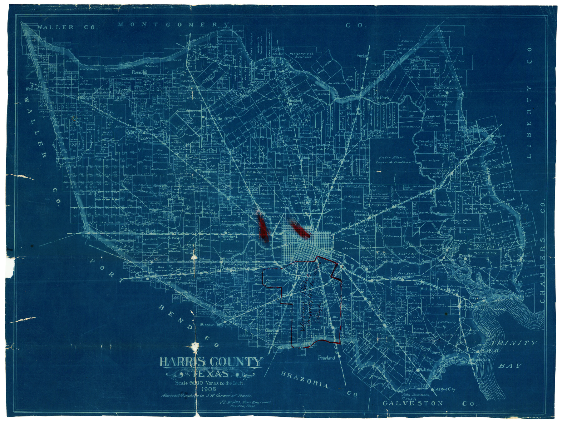
Harris County Texas
Harris County Sketch File 47
-
Map/Doc
11652
-
Collection
General Map Collection
-
Object Dates
1908 (Creation Date)
8/21/1908 (File Date)
-
People and Organizations
Texas General Land Office (Publisher)
J.S. Boyles (Surveyor/Engineer)
-
Counties
Harris
-
Subjects
County
-
Height x Width
19.7 x 24.7 inches
50.0 x 62.7 cm
-
Comments
Note on reverse side: "Blueprint map of Harris County showing Post Offices. 1908".
Part of: General Map Collection
Bosque County Working Sketch 18

Print $20.00
- Digital $50.00
Bosque County Working Sketch 18
1976
Size 18.8 x 24.4 inches
Map/Doc 67451
Baylor County Working Sketch 5

Print $20.00
- Digital $50.00
Baylor County Working Sketch 5
1940
Size 11.9 x 30.4 inches
Map/Doc 67290
Nueces County Rolled Sketch 113A

Print $20.00
- Digital $50.00
Nueces County Rolled Sketch 113A
1972
Size 19.1 x 24.4 inches
Map/Doc 7121
Orange County Working Sketch 31

Print $20.00
- Digital $50.00
Orange County Working Sketch 31
1955
Size 24.2 x 13.8 inches
Map/Doc 71363
Galveston County Sketch File 53

Print $119.00
- Digital $50.00
Galveston County Sketch File 53
1964
Size 14.3 x 8.8 inches
Map/Doc 23527
Runnels County Working Sketch 30b

Print $20.00
- Digital $50.00
Runnels County Working Sketch 30b
Size 23.2 x 25.3 inches
Map/Doc 63627
Howard County Working Sketch Graphic Index

Print $20.00
- Digital $50.00
Howard County Working Sketch Graphic Index
1922
Size 42.5 x 36.3 inches
Map/Doc 76583
Index sheet to accompany map of survey for connecting the inland waters along margin of the Gulf of Mexico from Donaldsonville in Louisiana to the Rio Grande River in Texas

Print $20.00
- Digital $50.00
Index sheet to accompany map of survey for connecting the inland waters along margin of the Gulf of Mexico from Donaldsonville in Louisiana to the Rio Grande River in Texas
1874
Size 18.1 x 26.9 inches
Map/Doc 72694
San Jacinto County Working Sketch 5

Print $20.00
- Digital $50.00
San Jacinto County Working Sketch 5
1934
Size 16.5 x 21.2 inches
Map/Doc 63718
Navigation Maps of Gulf Intracoastal Waterway, Port Arthur to Brownsville, Texas

Print $4.00
- Digital $50.00
Navigation Maps of Gulf Intracoastal Waterway, Port Arthur to Brownsville, Texas
1951
Size 16.7 x 21.2 inches
Map/Doc 65449
Flight Mission No. DIX-7P, Frame 87, Aransas County

Print $20.00
- Digital $50.00
Flight Mission No. DIX-7P, Frame 87, Aransas County
1956
Size 18.7 x 22.4 inches
Map/Doc 83881
Andrews County

Print $40.00
- Digital $50.00
Andrews County
1951
Size 42.7 x 54.5 inches
Map/Doc 1769
You may also like
Flight Mission No. BRA-8M, Frame 114, Jefferson County

Print $20.00
- Digital $50.00
Flight Mission No. BRA-8M, Frame 114, Jefferson County
1953
Size 18.6 x 22.2 inches
Map/Doc 85610
Palo Pinto County Sketch File 26

Print $8.00
- Digital $50.00
Palo Pinto County Sketch File 26
1993
Size 14.0 x 8.6 inches
Map/Doc 33441
United States - Gulf Coast Texas - Northern part of Laguna Madre

Print $20.00
- Digital $50.00
United States - Gulf Coast Texas - Northern part of Laguna Madre
1941
Size 18.3 x 24.0 inches
Map/Doc 72937
Blanco County Rolled Sketch 16

Print $20.00
- Digital $50.00
Blanco County Rolled Sketch 16
Size 18.8 x 19.4 inches
Map/Doc 5152
Spence Addition Owned by L.N. Goldbeck and Herman Pressler - A Subdivision of Outlot 43, Division "O"

Print $20.00
- Digital $50.00
Spence Addition Owned by L.N. Goldbeck and Herman Pressler - A Subdivision of Outlot 43, Division "O"
1913
Size 15.4 x 12.8 inches
Map/Doc 632
Working Sketch in Archer County

Print $20.00
- Digital $50.00
Working Sketch in Archer County
1924
Size 30.3 x 42.2 inches
Map/Doc 90171
Loving County Rolled Sketch 17

Print $40.00
- Digital $50.00
Loving County Rolled Sketch 17
2022
Size 38.2 x 49.3 inches
Map/Doc 97292
Terrell County Working Sketch 46

Print $20.00
- Digital $50.00
Terrell County Working Sketch 46
1958
Size 23.8 x 23.4 inches
Map/Doc 62139
[Sketch showing B. S. & F. Block 9 and vicinity]
![89786, [Sketch showing B. S. & F. Block 9 and vicinity], Twichell Survey Records](https://historictexasmaps.com/wmedia_w700/maps/89786-1.tif.jpg)
Print $20.00
- Digital $50.00
[Sketch showing B. S. & F. Block 9 and vicinity]
Size 39.0 x 47.6 inches
Map/Doc 89786
Map of Kinney County

Print $20.00
- Digital $50.00
Map of Kinney County
1879
Size 23.5 x 37.2 inches
Map/Doc 3778
Highway Map State of Texas

Print $20.00
Highway Map State of Texas
1919
Size 31.9 x 33.1 inches
Map/Doc 76291
Leon County Rolled Sketch 15

Print $20.00
- Digital $50.00
Leon County Rolled Sketch 15
1979
Size 23.5 x 18.9 inches
Map/Doc 6601