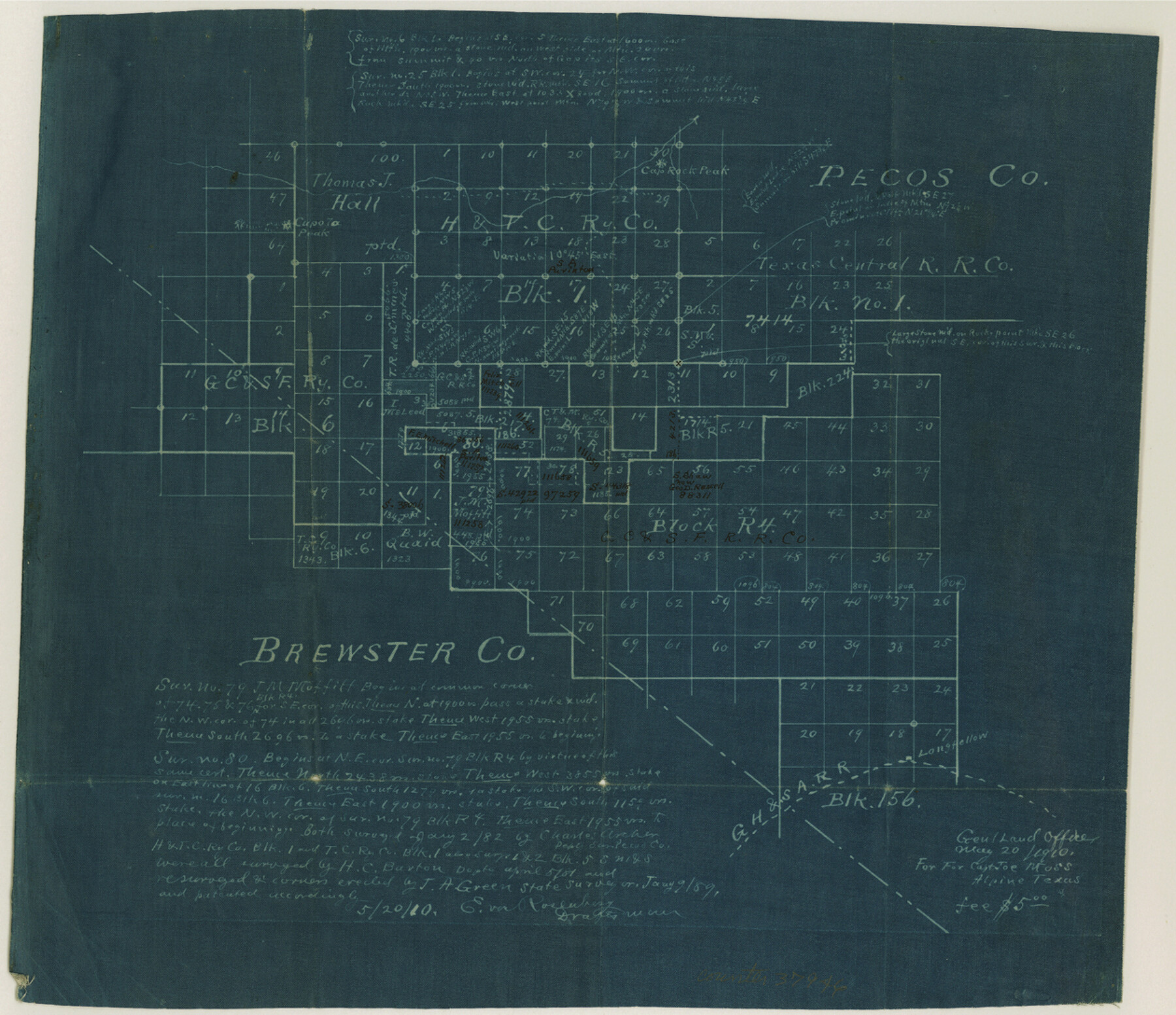
Terrell County Sketch File 20
[Office sketch of surveys north and northwest from Longfellow in Pecos and Brewster County]
-
Map/Doc
37946
-
Collection
General Map Collection
-
Object Dates
5/20/1910 (Creation Date)
-
People and Organizations
E. von Rosenberg (Draftsman)
-
Counties
Pecos Brewster
-
Subjects
Surveying Sketch File
-
Height x Width
10.9 x 12.6 inches
27.7 x 32.0 cm
-
Medium
blueprint/diazo
-
Features
Cap Rock Peak
GH&SA
Longfellow
Part of: General Map Collection
El Paso County Rolled Sketch 23

Print $20.00
- Digital $50.00
El Paso County Rolled Sketch 23
1888
Size 46.2 x 38.1 inches
Map/Doc 8856
Jeff Davis County Sketch File 9

Print $40.00
- Digital $50.00
Jeff Davis County Sketch File 9
Size 15.1 x 17.6 inches
Map/Doc 27920
Gonzales County Working Sketch 13

Print $2.00
- Digital $50.00
Gonzales County Working Sketch 13
1981
Size 12.5 x 7.6 inches
Map/Doc 63229
Gray County Boundary File 11

Print $80.00
- Digital $50.00
Gray County Boundary File 11
Size 20.7 x 19.7 inches
Map/Doc 53912
Shackelford County Working Sketch 10

Print $20.00
- Digital $50.00
Shackelford County Working Sketch 10
1984
Size 28.8 x 26.1 inches
Map/Doc 63850
Controlled Mosaic by Jack Amman Photogrammetric Engineers, Inc - Sheet 46

Print $20.00
- Digital $50.00
Controlled Mosaic by Jack Amman Photogrammetric Engineers, Inc - Sheet 46
1954
Size 20.0 x 24.0 inches
Map/Doc 83505
Hardeman County Sketch File 3

Print $8.00
- Digital $50.00
Hardeman County Sketch File 3
1880
Size 14.2 x 8.8 inches
Map/Doc 24987
Gillespie County Sketch File 17

Print $8.00
- Digital $50.00
Gillespie County Sketch File 17
1994
Size 11.2 x 8.7 inches
Map/Doc 24157
Crockett County Sketch File 39

Print $20.00
- Digital $50.00
Crockett County Sketch File 39
1889
Size 19.7 x 32.6 inches
Map/Doc 11221

Chambers County Working Sketch 23

Print $20.00
- Digital $50.00
Chambers County Working Sketch 23
1979
Size 14.9 x 23.5 inches
Map/Doc 68006
Motley County Sketch File 6 (N)

Print $20.00
- Digital $50.00
Motley County Sketch File 6 (N)
1900
Size 14.0 x 8.6 inches
Map/Doc 32004
You may also like
Williamson County

Print $40.00
- Digital $50.00
Williamson County
1946
Size 39.0 x 56.3 inches
Map/Doc 73326
Louisiana and Texas Intracoastal Waterway

Print $20.00
- Digital $50.00
Louisiana and Texas Intracoastal Waterway
1929
Size 13.8 x 19.9 inches
Map/Doc 83341
Sketch from Dawson, Martin and Gaines Co's. (a part of Andrews Co. added)

Print $40.00
- Digital $50.00
Sketch from Dawson, Martin and Gaines Co's. (a part of Andrews Co. added)
1900
Size 45.0 x 50.6 inches
Map/Doc 89781
Brewster County Working Sketch 50

Print $40.00
- Digital $50.00
Brewster County Working Sketch 50
1950
Size 31.5 x 48.4 inches
Map/Doc 67584
Greer County Sketch File 11

Print $6.00
- Digital $50.00
Greer County Sketch File 11
Size 14.2 x 8.8 inches
Map/Doc 24532
Colorado County Working Sketch 30

Print $20.00
- Digital $50.00
Colorado County Working Sketch 30
1980
Size 22.2 x 19.8 inches
Map/Doc 68130
![91112, [Block 1], Twichell Survey Records](https://historictexasmaps.com/wmedia_w700/maps/91112-1.tif.jpg)
Concho County Working Sketch 20

Print $20.00
- Digital $50.00
Concho County Working Sketch 20
1957
Size 40.0 x 38.1 inches
Map/Doc 68202
Garza County Rolled Sketch 6B

Print $20.00
- Digital $50.00
Garza County Rolled Sketch 6B
Size 27.6 x 36.4 inches
Map/Doc 5996
[Sketch showing School Lands]
![90448, [Sketch showing School Lands], Twichell Survey Records](https://historictexasmaps.com/wmedia_w700/maps/90448-1.tif.jpg)
Print $20.00
- Digital $50.00
[Sketch showing School Lands]
Size 16.3 x 12.2 inches
Map/Doc 90448
[Blocks W, A4, A2, T, D10, B, JD, O, JK4]
![92251, [Blocks W, A4, A2, T, D10, B, JD, O, JK4], Twichell Survey Records](https://historictexasmaps.com/wmedia_w700/maps/92251-1.tif.jpg)
Print $20.00
- Digital $50.00
[Blocks W, A4, A2, T, D10, B, JD, O, JK4]
Size 36.9 x 30.1 inches
Map/Doc 92251
Gonzales County Rolled Sketch 2

Print $20.00
- Digital $50.00
Gonzales County Rolled Sketch 2
2021
Size 24.0 x 35.9 inches
Map/Doc 96581