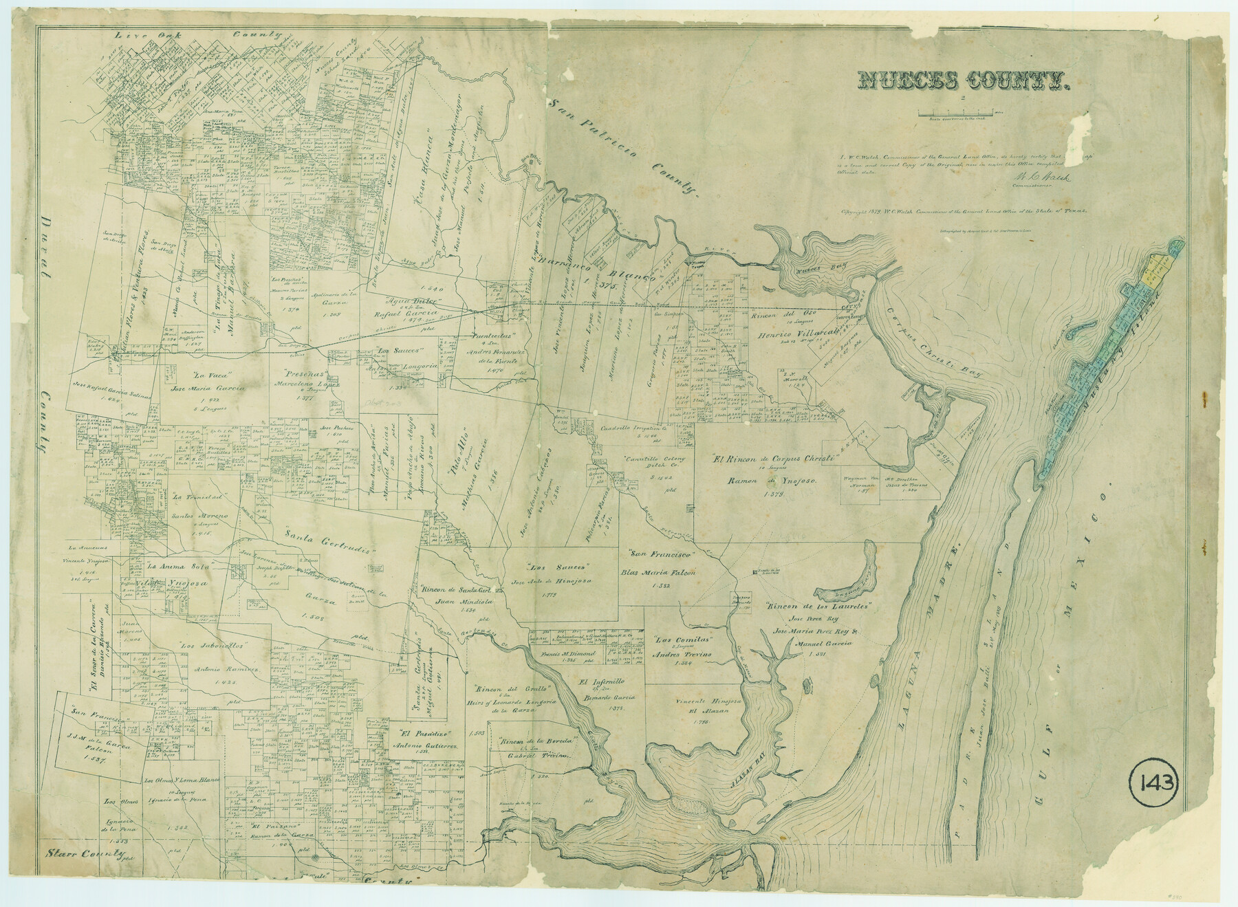
Nueces County, Texas
-
Map/Doc
590
-
Collection
Maddox Collection
-
Object Dates
1879 (Creation Date)
1879 (Copyright Date)
-
People and Organizations
General Land Office (Publisher)
W.C. Walsh (GLO Commissioner)
August Gast & Co. (Lithographer)
-
Counties
Nueces Live Oak
-
Subjects
County
-
Height x Width
29.3 x 40.0 inches
74.4 x 101.6 cm
-
Medium
paper, etching/engraving/lithograph
-
Scale
1:4000
-
Comments
Conservation funded in 2003 with donation from the Corpus Christi Association of Professional Landmen
-
Features
Gulf of Mexico
Santa Petronilla Creek
San Fernando Creek
Andres Creek
Anagira Creek
Escondido Creek
Santa Gertrudis Creek
Tunas Creek
Rancho de los Laureles
Laguna Larga
Laguna Madre
Cayo del Oso
Padre Island
Perra Lake
Cayo dde Mazan
Grullo Bayou
Alazan Bay
Rancho de la Bo[]eda
Arora Lagoon
El Paisano Creek
Los Olmos Creek
Collins
San Patricio
Nueces Bay
Nueces River
Nueces Town
Agua Dulce Creek
San Diego
Chiltipin Creek
Resaca de Emedio
San Diego Creek
Arroyo Lagarta
CCSD&RGNG
Banquette Town
Corpus Christi
Corpus Christi Bay
Shamrock Point
Mustang Island
Shell Point
Oso Creek
Pinias Creek
Part of: Maddox Collection
[Sketch of surveys north of "Las Animas" grant, Webb County]
![668, [Sketch of surveys north of "Las Animas" grant, Webb County], Maddox Collection](https://historictexasmaps.com/wmedia_w700/maps/668.tif.jpg)
Print $3.00
- Digital $50.00
[Sketch of surveys north of "Las Animas" grant, Webb County]
1908
Size 16.9 x 10.7 inches
Map/Doc 668
[Sketch showing surveys in Sutton and Val Verde Counties, Texas]
![10779, [Sketch showing surveys in Sutton and Val Verde Counties, Texas], Maddox Collection](https://historictexasmaps.com/wmedia_w700/maps/10779-1.tif.jpg)
Print $20.00
- Digital $50.00
[Sketch showing surveys in Sutton and Val Verde Counties, Texas]
1880
Size 28.0 x 14.5 inches
Map/Doc 10779
Guadalupe County, Texas

Print $20.00
- Digital $50.00
Guadalupe County, Texas
1880
Size 24.7 x 22.5 inches
Map/Doc 491
Map of Brazos County, Texas

Print $20.00
- Digital $50.00
Map of Brazos County, Texas
1879
Size 21.6 x 15.3 inches
Map/Doc 597
Map showing the resurvey of Block M24 T. C. R.R. Co. in Hutchinson County, Texas

Print $20.00
- Digital $50.00
Map showing the resurvey of Block M24 T. C. R.R. Co. in Hutchinson County, Texas
Size 28.8 x 30.8 inches
Map/Doc 76178
Tracing from a map of Swisher Subdivision of part of the Isaac Decker league southside Colorado River an addition to the City of Austin

Print $20.00
- Digital $50.00
Tracing from a map of Swisher Subdivision of part of the Isaac Decker league southside Colorado River an addition to the City of Austin
1877
Size 24.0 x 14.6 inches
Map/Doc 455
[Surveying Sketch of J.H. Vermillion, S.L. Fite, et al in Zapata County]
![698, [Surveying Sketch of J.H. Vermillion, S.L. Fite, et al in Zapata County], Maddox Collection](https://historictexasmaps.com/wmedia_w700/maps/0698.tif.jpg)
Print $20.00
- Digital $50.00
[Surveying Sketch of J.H. Vermillion, S.L. Fite, et al in Zapata County]
1914
Size 15.6 x 12.1 inches
Map/Doc 698
[Sketch of Surveys in Brooks County, Texas]
![10775, [Sketch of Surveys in Brooks County, Texas], Maddox Collection](https://historictexasmaps.com/wmedia_w700/maps/10775-1.tif.jpg)
Print $20.00
- Digital $50.00
[Sketch of Surveys in Brooks County, Texas]
Size 12.1 x 12.4 inches
Map/Doc 10775
Ochiltree County, Texas

Print $20.00
- Digital $50.00
Ochiltree County, Texas
1870
Size 21.4 x 19.7 inches
Map/Doc 507
[Partial Map of Polk County, Texas]
![78452, [Partial Map of Polk County, Texas], Maddox Collection](https://historictexasmaps.com/wmedia_w700/maps/78452.tif.jpg)
Print $20.00
- Digital $50.00
[Partial Map of Polk County, Texas]
Size 16.6 x 12.3 inches
Map/Doc 78452
Map of Surveys on Harbor Island

Print $40.00
- Digital $50.00
Map of Surveys on Harbor Island
1912
Size 57.3 x 42.2 inches
Map/Doc 594
Map of Hardin County, Texas

Print $20.00
- Digital $50.00
Map of Hardin County, Texas
1895
Size 22.1 x 20.9 inches
Map/Doc 499
You may also like
Parker County Working Sketch 18

Print $20.00
- Digital $50.00
Parker County Working Sketch 18
2000
Map/Doc 71468
Matagorda County Sketch File 43

Print $20.00
- Digital $50.00
Matagorda County Sketch File 43
1839
Size 13.2 x 8.2 inches
Map/Doc 30868

Map of Trinity County

Print $20.00
- Digital $50.00
Map of Trinity County
Size 17.8 x 24.8 inches
Map/Doc 760
Presidio County Sketch File 99

Print $8.00
- Digital $50.00
Presidio County Sketch File 99
1955
Size 11.2 x 8.8 inches
Map/Doc 34787
Mitchell Estate Subdivision

Print $20.00
- Digital $50.00
Mitchell Estate Subdivision
1953
Size 9.3 x 19.8 inches
Map/Doc 92505
Dawson County Working Sketch 10

Print $20.00
- Digital $50.00
Dawson County Working Sketch 10
1944
Size 15.6 x 13.6 inches
Map/Doc 68554
Childress County Rolled Sketch 8B

Print $20.00
- Digital $50.00
Childress County Rolled Sketch 8B
Size 13.3 x 18.8 inches
Map/Doc 5444
General Highway Map, Live Oak County, Texas

Print $20.00
General Highway Map, Live Oak County, Texas
1940
Size 18.5 x 24.8 inches
Map/Doc 79176
Chambers County Sketch File 6

Print $4.00
- Digital $50.00
Chambers County Sketch File 6
1863
Size 9.1 x 8.5 inches
Map/Doc 17540
[Surveys in Austin's Colony along the Brazos River]
![214, [Surveys in Austin's Colony along the Brazos River], General Map Collection](https://historictexasmaps.com/wmedia_w700/maps/214.tif.jpg)
Print $2.00
- Digital $50.00
[Surveys in Austin's Colony along the Brazos River]
Size 9.0 x 8.7 inches
Map/Doc 214
Blanco County Sketch File 19

Print $4.00
- Digital $50.00
Blanco County Sketch File 19
1878
Size 12.2 x 8.0 inches
Map/Doc 14596