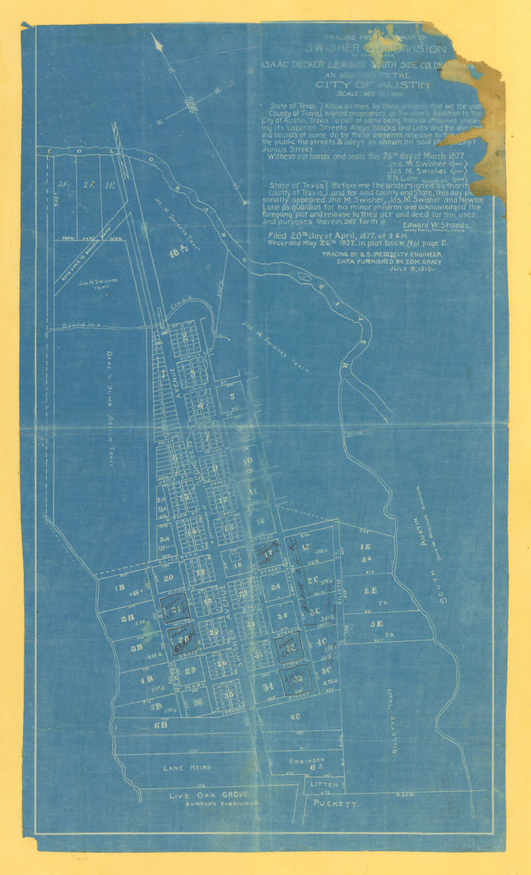
Tracing from a map of Swisher Subdivision of part of the Isaac Decker league southside Colorado River an addition to the City of Austin
-
Map/Doc
455
-
Collection
Maddox Collection
-
Object Dates
1877/3/26 (Creation Date)
1910/7/9 (Copy/Tracing Date)
-
People and Organizations
Jno. M. Swisher (Author)
Jas. M. Swisher (Author)
R.N. Lane (Author)
Edward W. Shands (Agent)
G.S. Iredell (Tracer)
-
Counties
Travis
-
Height x Width
24.0 x 14.6 inches
61.0 x 37.1 cm
-
Medium
blueprint/diazo
-
Scale
1" = 400 feet
-
Comments
Recorded May 26, 1877. Tracing by G. S. Iredell, City Engineer. Data furnished by Com. Gracy July 9, 1910.
-
Features
Milton Street
Junius Street
Congress Avenue
John Street
Nellie Street
James Street
Gibson Street
Brackenridge Street
Nickerson Street
Elizabeth Street
Gillette Street
Monroe Street
Swisher Subdivision
Annie Street
Mary Street
Johanna Street
Newton Street
Swisher Avenue
Road Dyke to Bouldin Road
Live Oak Grove/Bunton's Subdivision
Davis and Wheelock's Subdivision
Bouldins Creek
Colorado River
Part of: Maddox Collection
Dickens County, Texas

Print $20.00
- Digital $50.00
Dickens County, Texas
1891
Size 24.5 x 20.4 inches
Map/Doc 707
Surveys in Greer Co.

Print $20.00
- Digital $50.00
Surveys in Greer Co.
Size 16.6 x 14.4 inches
Map/Doc 557
[Surveying Sketch of John Knight, Champion Choate, A.M. Lejarza, et al in Hardin County, Texas - Exhibit "G"]
![75822, [Surveying Sketch of John Knight, Champion Choate, A.M. Lejarza, et al in Hardin County, Texas - Exhibit "G"], Maddox Collection](https://historictexasmaps.com/wmedia_w700/maps/75822.tif.jpg)
Print $20.00
- Digital $50.00
[Surveying Sketch of John Knight, Champion Choate, A.M. Lejarza, et al in Hardin County, Texas - Exhibit "G"]
Size 18.3 x 23.5 inches
Map/Doc 75822
Sketch of the Designation of Route of the Aransas Channel Harbor & Dock Company's Deep Water Channel

Print $3.00
- Digital $50.00
Sketch of the Designation of Route of the Aransas Channel Harbor & Dock Company's Deep Water Channel
Size 13.2 x 10.0 inches
Map/Doc 4495
Hall County, Texas

Print $20.00
- Digital $50.00
Hall County, Texas
1880
Size 24.9 x 20.4 inches
Map/Doc 480
Palo Pinto County, Texas

Print $20.00
- Digital $50.00
Palo Pinto County, Texas
1871
Size 28.8 x 23.4 inches
Map/Doc 660
[Sketch showing voting precincts in Jim Hogg and Brooks Counties]
![4497, [Sketch showing voting precincts in Jim Hogg and Brooks Counties], Maddox Collection](https://historictexasmaps.com/wmedia_w700/maps/4497-1.tif.jpg)
Print $20.00
- Digital $50.00
[Sketch showing voting precincts in Jim Hogg and Brooks Counties]
Size 10.1 x 18.2 inches
Map/Doc 4497
[Sketch of San Antonio del Encinal, Hidalgo County, Texas]
![4457, [Sketch of San Antonio del Encinal, Hidalgo County, Texas], Maddox Collection](https://historictexasmaps.com/wmedia_w700/maps/4457-1.tif.jpg)
Print $20.00
- Digital $50.00
[Sketch of San Antonio del Encinal, Hidalgo County, Texas]
Size 12.1 x 27.1 inches
Map/Doc 4457
Sketch of part of the NW part, Hutchinson County

Print $20.00
- Digital $50.00
Sketch of part of the NW part, Hutchinson County
1909
Size 20.9 x 31.2 inches
Map/Doc 75816
Survey 4, Block 1, D.B. Gardner

Print $20.00
- Digital $50.00
Survey 4, Block 1, D.B. Gardner
1914
Size 26.6 x 13.7 inches
Map/Doc 10769
[Vague Sketches in Brooks County, Texas]
![83352, [Vague Sketches in Brooks County, Texas], Maddox Collection](https://historictexasmaps.com/wmedia_w700/maps/83352.tif.jpg)
Print $20.00
- Digital $50.00
[Vague Sketches in Brooks County, Texas]
1906
Size 17.8 x 19.9 inches
Map/Doc 83352
Map of Shackelford County, Texas

Print $20.00
- Digital $50.00
Map of Shackelford County, Texas
1879
Size 28.7 x 23.4 inches
Map/Doc 616
You may also like
Andrews County Rolled Sketch 22

Print $20.00
- Digital $50.00
Andrews County Rolled Sketch 22
1946
Size 26.4 x 24.0 inches
Map/Doc 77170
Rio Grande Rectification Project, El Paso and Juarez Valley

Print $20.00
- Digital $50.00
Rio Grande Rectification Project, El Paso and Juarez Valley
1935
Size 11.0 x 29.7 inches
Map/Doc 60864
Terrell County Sketch File 12

Print $4.00
- Digital $50.00
Terrell County Sketch File 12
1903
Size 5.7 x 8.5 inches
Map/Doc 37922
Victoria County Rolled Sketch 5

Print $20.00
- Digital $50.00
Victoria County Rolled Sketch 5
1961
Size 27.8 x 43.8 inches
Map/Doc 8151
McLennan County

Print $20.00
- Digital $50.00
McLennan County
1946
Size 42.5 x 45.8 inches
Map/Doc 73235
Coleman County Sketch File 46

Print $20.00
- Digital $50.00
Coleman County Sketch File 46
1894
Size 24.0 x 21.8 inches
Map/Doc 11125
Jeff Davis County Working Sketch 23

Print $20.00
- Digital $50.00
Jeff Davis County Working Sketch 23
1958
Size 41.5 x 30.7 inches
Map/Doc 66518
Flight Mission No. DQN-2K, Frame 65, Calhoun County

Print $20.00
- Digital $50.00
Flight Mission No. DQN-2K, Frame 65, Calhoun County
1953
Size 18.5 x 22.2 inches
Map/Doc 84257
Uvalde County Working Sketch 45

Print $20.00
- Digital $50.00
Uvalde County Working Sketch 45
1978
Size 18.5 x 28.2 inches
Map/Doc 72115
Henderson County

Print $40.00
- Digital $50.00
Henderson County
1988
Size 34.6 x 68.7 inches
Map/Doc 73178
Flight Mission No. CUG-1P, Frame 5, Kleberg County

Print $20.00
- Digital $50.00
Flight Mission No. CUG-1P, Frame 5, Kleberg County
1956
Size 18.8 x 22.5 inches
Map/Doc 86108
Hamilton County Working Sketch 17

Print $20.00
- Digital $50.00
Hamilton County Working Sketch 17
1951
Size 44.4 x 25.0 inches
Map/Doc 63355