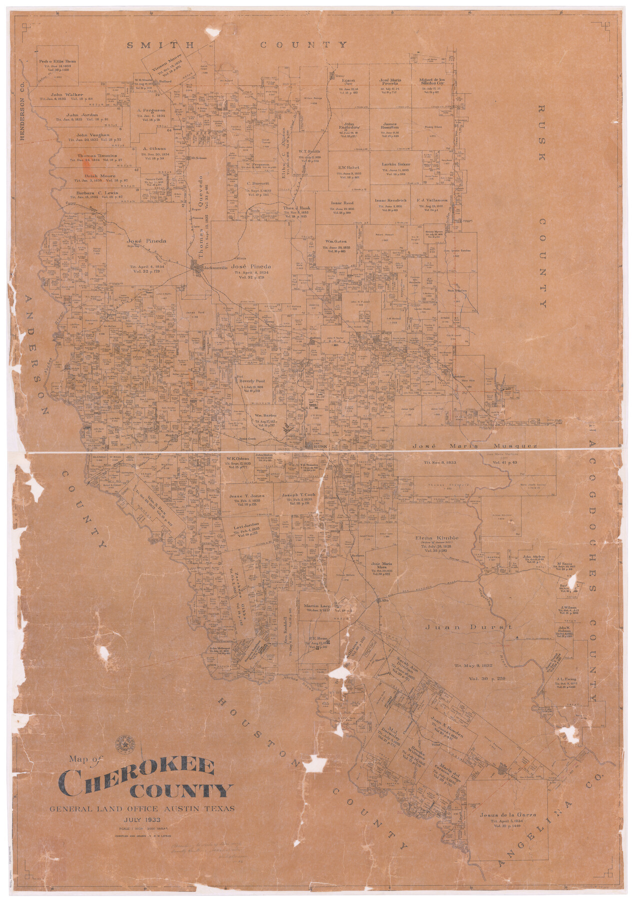
Cherokee County
-
Map/Doc
73104
-
Collection
General Map Collection
-
Object Dates
1933 (Creation Date)
-
People and Organizations
Texas General Land Office (Publisher)
W.W. Latson (Compiler)
W.W. Latson (Draftsman)
-
Counties
Cherokee
-
Subjects
County
-
Height x Width
54.7 x 38.7 inches
138.9 x 98.3 cm
-
Comments
Hand lettered.
-
Features
Beans Creek
Angelina River
Old San Antonio Road
Beaver Creek
Redlawn
Cane Creek
Bull Creek
Broughton
Rusk
Beans Creek
Ainais Trace
One Arm Creek
TSR
Maydelle
Talles
Mewshaw
Slough [of Mud Creek]
Hog Spring
Hog Spring
Chronister
Carltharp Ferry
Devil's Bayou
Larison's Bayou
Forest
Slough [of Angelina River]
Wells
Dan's Branch [of Bowman Creek]
Bowman Creek
Reklaw
Norvall
Aspen
Slough [of Neches River]
Neches River
Brunswick
Morrill
Road to Nacogdoches
Alto
Gould
Grover Creek
Frys Gap
T&NO
Jordan Creek
Reese
Cuney
Pomona
Hogan
Tecula
Jacksonville
I&GN
SL&SW
Mount Selman
Denman
West Mud Creek
Mud Creek
Troup
Bullard
Turney
East Fork of Angelina River
West Fork of Angelina River
Horse Creek
Ponta
Rusk Branch of T&NO
Gallatin
Checkup
Turnpike Creek
Saline Creek
Dial
Prices
Owl Creek
Ironton
Hume
Striker Creek
Mittie
Love
Part of: General Map Collection
Edwards County Sketch File 16b

Print $56.00
- Digital $50.00
Edwards County Sketch File 16b
1907
Size 9.4 x 8.7 inches
Map/Doc 21722
Wichita County Working Sketch 22

Print $20.00
- Digital $50.00
Wichita County Working Sketch 22
1952
Size 22.2 x 27.1 inches
Map/Doc 72532
Flight Mission No. CLL-3N, Frame 7, Willacy County

Print $20.00
- Digital $50.00
Flight Mission No. CLL-3N, Frame 7, Willacy County
1954
Size 18.4 x 22.1 inches
Map/Doc 87073
Presidio County Working Sketch 82

Print $40.00
- Digital $50.00
Presidio County Working Sketch 82
1967
Size 48.6 x 67.2 inches
Map/Doc 71759
Upton County Rolled Sketch 26

Print $20.00
- Digital $50.00
Upton County Rolled Sketch 26
1942
Size 35.7 x 37.2 inches
Map/Doc 10045
Lavaca County Sketch File 6

Print $2.00
- Digital $50.00
Lavaca County Sketch File 6
Size 7.3 x 3.2 inches
Map/Doc 29641
Flight Mission No. CRC-3R, Frame 202, Chambers County

Print $20.00
- Digital $50.00
Flight Mission No. CRC-3R, Frame 202, Chambers County
1956
Size 18.7 x 22.4 inches
Map/Doc 84857
Hartley County Rolled Sketch 5

Print $20.00
- Digital $50.00
Hartley County Rolled Sketch 5
Size 26.1 x 22.0 inches
Map/Doc 6160
Map of Jack County

Print $20.00
- Digital $50.00
Map of Jack County
Size 18.7 x 15.9 inches
Map/Doc 3703
Brewster County Working Sketch 51

Print $40.00
- Digital $50.00
Brewster County Working Sketch 51
1950
Size 62.9 x 26.4 inches
Map/Doc 67585
[Sketch for Mineral Application 26649-26650 - Sabine River, Harry A. Wolan]
![2852, [Sketch for Mineral Application 26649-26650 - Sabine River, Harry A. Wolan], General Map Collection](https://historictexasmaps.com/wmedia_w700/maps/2852-1.tif.jpg)
Print $40.00
- Digital $50.00
[Sketch for Mineral Application 26649-26650 - Sabine River, Harry A. Wolan]
1931
Size 36.9 x 72.2 inches
Map/Doc 2852
Old Miscellaneous File 28

Print $6.00
- Digital $50.00
Old Miscellaneous File 28
1838
Size 10.2 x 8.4 inches
Map/Doc 75736
You may also like
Texas Intracoastal Waterway, Aransas Bay to Aransas Pass

Print $20.00
- Digital $50.00
Texas Intracoastal Waterway, Aransas Bay to Aransas Pass
1957
Size 27.5 x 39.1 inches
Map/Doc 73436
Burnet County Sketch File 42

Print $28.00
- Digital $50.00
Burnet County Sketch File 42
1950
Size 9.9 x 8.8 inches
Map/Doc 16760
Wichita County Sketch File 27

Print $52.00
- Digital $50.00
Wichita County Sketch File 27
1925
Size 9.1 x 7.9 inches
Map/Doc 40114
Anderson County Sketch File 19

Print $40.00
- Digital $50.00
Anderson County Sketch File 19
Size 18.2 x 15.9 inches
Map/Doc 10802
Aransas County Sketch File 35

Print $61.00
- Digital $50.00
Aransas County Sketch File 35
1984
Size 11.0 x 8.8 inches
Map/Doc 13347
Coryelle County

Print $20.00
- Digital $50.00
Coryelle County
1855
Size 18.6 x 23.1 inches
Map/Doc 51904
Brewster County Sketch File S-26a

Print $18.00
- Digital $50.00
Brewster County Sketch File S-26a
1964
Size 11.1 x 8.7 inches
Map/Doc 15837
Mitchell County Working Sketch 4

Print $20.00
- Digital $50.00
Mitchell County Working Sketch 4
1926
Size 28.5 x 31.5 inches
Map/Doc 71061
Mitchell County Rolled Sketch 2A

Print $20.00
- Digital $50.00
Mitchell County Rolled Sketch 2A
Size 24.2 x 18.5 inches
Map/Doc 88857
Sabine County Sketch File 4

Print $22.00
Sabine County Sketch File 4
1876
Size 8.1 x 12.8 inches
Map/Doc 35606
[Capitol Leagues 661-729]
![91187, [Capitol Leagues 661-729], Twichell Survey Records](https://historictexasmaps.com/wmedia_w700/maps/91187-1.tif.jpg)
Print $20.00
- Digital $50.00
[Capitol Leagues 661-729]
Size 20.6 x 28.6 inches
Map/Doc 91187
Upton County Sketch File 21

Print $20.00
- Digital $50.00
Upton County Sketch File 21
1927
Size 15.0 x 23.7 inches
Map/Doc 12518