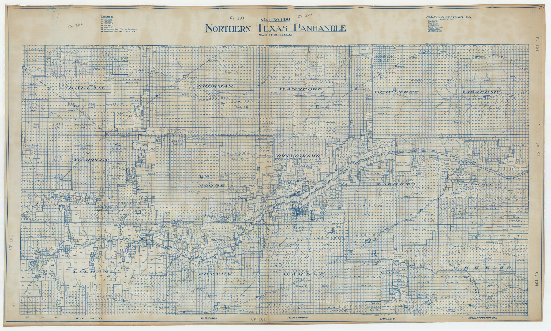
Northern Texas Panhandle
CV101
-
Map/Doc
89915
-
Collection
Twichell Survey Records
-
Object Dates
1926 (Creation Date)
-
People and Organizations
Amarillo Abstract Co. (Publisher)
-
Counties
Dallam Sherman Hansford
-
Height x Width
71.6 x 43.0 inches
181.9 x 109.2 cm
-
Comments
Copyrighted and unavailable for duplication.
Part of: Twichell Survey Records
[Southwest corner Runnels County School Land League 3 and vicinity]
![93114, [Southwest corner Runnels County School Land League 3 and vicinity], Twichell Survey Records](https://historictexasmaps.com/wmedia_w700/maps/93114-1.tif.jpg)
Print $20.00
- Digital $50.00
[Southwest corner Runnels County School Land League 3 and vicinity]
Size 42.5 x 31.5 inches
Map/Doc 93114
[Township 3 North, Block 34]
![91208, [Township 3 North, Block 34], Twichell Survey Records](https://historictexasmaps.com/wmedia_w700/maps/91208-1.tif.jpg)
Print $3.00
- Digital $50.00
[Township 3 North, Block 34]
Size 10.2 x 14.0 inches
Map/Doc 91208
[Leagues 27, 28, 69, 70, 71, 72, and 73]
![91097, [Leagues 27, 28, 69, 70, 71, 72, and 73], Twichell Survey Records](https://historictexasmaps.com/wmedia_w700/maps/91097-1.tif.jpg)
Print $20.00
- Digital $50.00
[Leagues 27, 28, 69, 70, 71, 72, and 73]
Size 23.8 x 16.3 inches
Map/Doc 91097
[Pencil sketch of surveys 820-831 along river]
![91983, [Pencil sketch of surveys 820-831 along river], Twichell Survey Records](https://historictexasmaps.com/wmedia_w700/maps/91983-1.tif.jpg)
Print $20.00
- Digital $50.00
[Pencil sketch of surveys 820-831 along river]
Size 23.0 x 10.3 inches
Map/Doc 91983
[Map of Resurvey of Block 34 and 35, Township 5 N]
![90551, [Map of Resurvey of Block 34 and 35, Township 5 N], Twichell Survey Records](https://historictexasmaps.com/wmedia_w700/maps/90551-1.tif.jpg)
Print $20.00
- Digital $50.00
[Map of Resurvey of Block 34 and 35, Township 5 N]
1915
Size 25.5 x 16.4 inches
Map/Doc 90551
[Capitol Leagues in Southwest Hartley and Northwest Oldham Counties]
![90723, [Capitol Leagues in Southwest Hartley and Northwest Oldham Counties], Twichell Survey Records](https://historictexasmaps.com/wmedia_w700/maps/90723-1.tif.jpg)
Print $20.00
- Digital $50.00
[Capitol Leagues in Southwest Hartley and Northwest Oldham Counties]
Size 13.8 x 18.0 inches
Map/Doc 90723
Hockley County Sketch, Mineral Application Number 38245

Print $20.00
- Digital $50.00
Hockley County Sketch, Mineral Application Number 38245
Size 27.2 x 10.8 inches
Map/Doc 91093
Part of Garza, Crosby, Lynn, and Lubbock Counties

Print $20.00
- Digital $50.00
Part of Garza, Crosby, Lynn, and Lubbock Counties
1912
Size 39.6 x 26.0 inches
Map/Doc 92560
Subdivision Map of Childress County School Land situated in Bailey and Cochran Counties, Tex.

Print $20.00
- Digital $50.00
Subdivision Map of Childress County School Land situated in Bailey and Cochran Counties, Tex.
Size 22.8 x 26.2 inches
Map/Doc 90200
[East Neches River]
![90420, [East Neches River], Twichell Survey Records](https://historictexasmaps.com/wmedia_w700/maps/90420-1.tif.jpg)
Print $20.00
- Digital $50.00
[East Neches River]
Size 25.8 x 29.3 inches
Map/Doc 90420
Southwest Part of Anton Chico Grant Guadalupe County, New Mexico

Print $20.00
- Digital $50.00
Southwest Part of Anton Chico Grant Guadalupe County, New Mexico
Size 23.8 x 28.6 inches
Map/Doc 92435
[Sections 302-313 and sections south of Blocks D and AX]
![92017, [Sections 302-313 and sections south of Blocks D and AX], Twichell Survey Records](https://historictexasmaps.com/wmedia_w700/maps/92017-1.tif.jpg)
Print $20.00
- Digital $50.00
[Sections 302-313 and sections south of Blocks D and AX]
Size 17.5 x 35.6 inches
Map/Doc 92017
You may also like
Report of Construction re: MA 46948, H. C. Henson

Print $2.00
- Digital $50.00
Report of Construction re: MA 46948, H. C. Henson
1954
Size 11.1 x 8.9 inches
Map/Doc 62571
Roberts County Rolled Sketch 4

Print $52.00
- Digital $50.00
Roberts County Rolled Sketch 4
2006
Size 66.9 x 20.0 inches
Map/Doc 83620
Flight Mission No. BRE-1P, Frame 71, Nueces County

Print $20.00
- Digital $50.00
Flight Mission No. BRE-1P, Frame 71, Nueces County
1956
Size 18.6 x 22.2 inches
Map/Doc 86653
Gray County Sketch File 10

Print $14.00
- Digital $50.00
Gray County Sketch File 10
Size 9.7 x 6.3 inches
Map/Doc 24445
General Highway Map, Goliad County, Texas

Print $20.00
General Highway Map, Goliad County, Texas
1940
Size 18.7 x 25.1 inches
Map/Doc 79101
Coleman County Working Sketch 22

Print $20.00
- Digital $50.00
Coleman County Working Sketch 22
1953
Size 34.6 x 41.0 inches
Map/Doc 68088
Brewster County Rolled Sketch 76

Print $20.00
- Digital $50.00
Brewster County Rolled Sketch 76
Size 17.3 x 19.0 inches
Map/Doc 5241
Maverick County Rolled Sketch 13

Print $20.00
- Digital $50.00
Maverick County Rolled Sketch 13
1848
Size 34.4 x 26.5 inches
Map/Doc 6706
[Map of Oldham County]
![91456, [Map of Oldham County], Twichell Survey Records](https://historictexasmaps.com/wmedia_w700/maps/91456-1.tif.jpg)
Print $20.00
- Digital $50.00
[Map of Oldham County]
Size 28.4 x 20.5 inches
Map/Doc 91456
Shackelford County Working Sketch 5

Print $20.00
- Digital $50.00
Shackelford County Working Sketch 5
1936
Size 22.5 x 31.6 inches
Map/Doc 63845
Cecil Stein Drilling Block

Print $3.00
- Digital $50.00
Cecil Stein Drilling Block
1951
Size 12.3 x 9.5 inches
Map/Doc 92280
Flight Mission No. BQR-22K, Frame 42, Brazoria County

Print $20.00
- Digital $50.00
Flight Mission No. BQR-22K, Frame 42, Brazoria County
1953
Size 18.9 x 22.7 inches
Map/Doc 84126