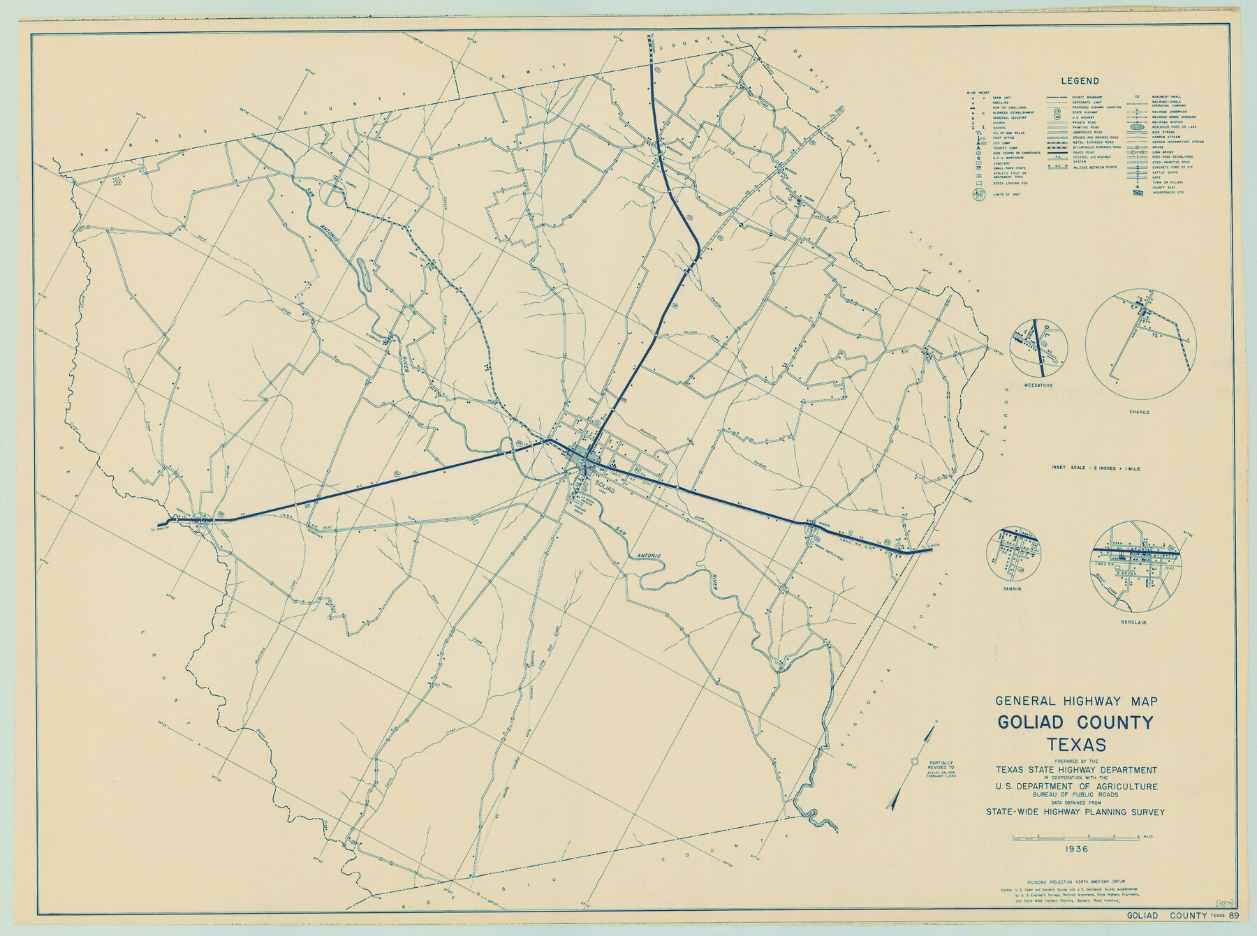
General Highway Map, Goliad County, Texas
-
Map/Doc
79101
-
Collection
Texas State Library and Archives
-
Object Dates
1940 (Creation Date)
-
People and Organizations
Texas State Highway Department (Publisher)
-
Counties
Goliad
-
Subjects
County
-
Height x Width
18.7 x 25.1 inches
47.5 x 63.8 cm
-
Comments
Prints available courtesy of the Texas State Library and Archives.
More info can be found here: TSLAC Map 04870
Part of: Texas State Library and Archives
General Highway Map, Hidalgo County, Texas

Print $20.00
General Highway Map, Hidalgo County, Texas
1940
Size 18.4 x 25.0 inches
Map/Doc 79128
General Highway Map, Loving County, Texas

Print $20.00
General Highway Map, Loving County, Texas
1961
Size 18.1 x 24.6 inches
Map/Doc 79577
General Highway Map, Dickens County, Texas

Print $20.00
General Highway Map, Dickens County, Texas
1961
Size 18.2 x 24.9 inches
Map/Doc 79443
Railroad and County Map of Texas

Print $20.00
Railroad and County Map of Texas
1901
Size 33.1 x 37.1 inches
Map/Doc 76213
General Highway Map, Maverick County, Zavala County, Texas

Print $20.00
General Highway Map, Maverick County, Zavala County, Texas
1940
Size 18.6 x 24.7 inches
Map/Doc 79189
General Highway Map, Orange County, Texas

Print $20.00
General Highway Map, Orange County, Texas
1961
Size 18.1 x 24.5 inches
Map/Doc 79621
Map of Texas, compiled from surveys on record in the General Land Office of the Republic

Print $20.00
Map of Texas, compiled from surveys on record in the General Land Office of the Republic
1839
Size 32.0 x 24.9 inches
Map/Doc 76198
General Highway Map, Lipscomb County, Texas

Print $20.00
General Highway Map, Lipscomb County, Texas
1940
Size 18.2 x 24.7 inches
Map/Doc 79175
General Highway Map, Stonewall County, Texas

Print $20.00
General Highway Map, Stonewall County, Texas
1940
Size 18.3 x 24.8 inches
Map/Doc 79249
General Highway Map, Newton County, Texas

Print $20.00
General Highway Map, Newton County, Texas
1961
Size 19.3 x 25.0 inches
Map/Doc 79612
General Highway Map, Kenedy County, Texas

Print $20.00
General Highway Map, Kenedy County, Texas
1940
Size 18.5 x 24.9 inches
Map/Doc 79154
Oil and Gas Fields in the State of Texas

Print $40.00
Oil and Gas Fields in the State of Texas
1927
Size 58.2 x 38.1 inches
Map/Doc 76303
You may also like
Kinney County Working Sketch 11

Print $20.00
- Digital $50.00
Kinney County Working Sketch 11
1941
Size 20.8 x 31.7 inches
Map/Doc 70193
Blanco County Sketch File 12

Print $20.00
- Digital $50.00
Blanco County Sketch File 12
Size 15.0 x 19.8 inches
Map/Doc 10928
Harris County Sketch File 32a

Print $4.00
- Digital $50.00
Harris County Sketch File 32a
1895
Size 14.1 x 9.0 inches
Map/Doc 25436
Oldham County Working Sketch 9

Print $20.00
- Digital $50.00
Oldham County Working Sketch 9
1982
Size 33.3 x 37.2 inches
Map/Doc 71331
[Surveys along the San Jacinto River]
![62, [Surveys along the San Jacinto River], General Map Collection](https://historictexasmaps.com/wmedia_w700/maps/62.tif.jpg)
Print $3.00
- Digital $50.00
[Surveys along the San Jacinto River]
1841
Size 10.7 x 14.5 inches
Map/Doc 62
Hardeman County Sketch File 5

Print $6.00
- Digital $50.00
Hardeman County Sketch File 5
Size 12.9 x 4.4 inches
Map/Doc 24994
Kimble County Working Sketch 90

Print $20.00
- Digital $50.00
Kimble County Working Sketch 90
1979
Size 17.3 x 28.2 inches
Map/Doc 70158
Loving County Rolled Sketch 1

Print $40.00
- Digital $50.00
Loving County Rolled Sketch 1
Size 42.5 x 79.5 inches
Map/Doc 9460
Crockett County Working Sketch 22

Print $20.00
- Digital $50.00
Crockett County Working Sketch 22
1920
Size 25.6 x 19.5 inches
Map/Doc 68355
Red River County Sketch File 8

Print $22.00
- Digital $50.00
Red River County Sketch File 8
Size 14.7 x 16.8 inches
Map/Doc 35112
Starr County Sketch File 17

Print $24.00
- Digital $50.00
Starr County Sketch File 17
1880
Size 12.8 x 8.2 inches
Map/Doc 36874
Live Oak County

Print $40.00
- Digital $50.00
Live Oak County
1899
Size 52.1 x 37.5 inches
Map/Doc 78423