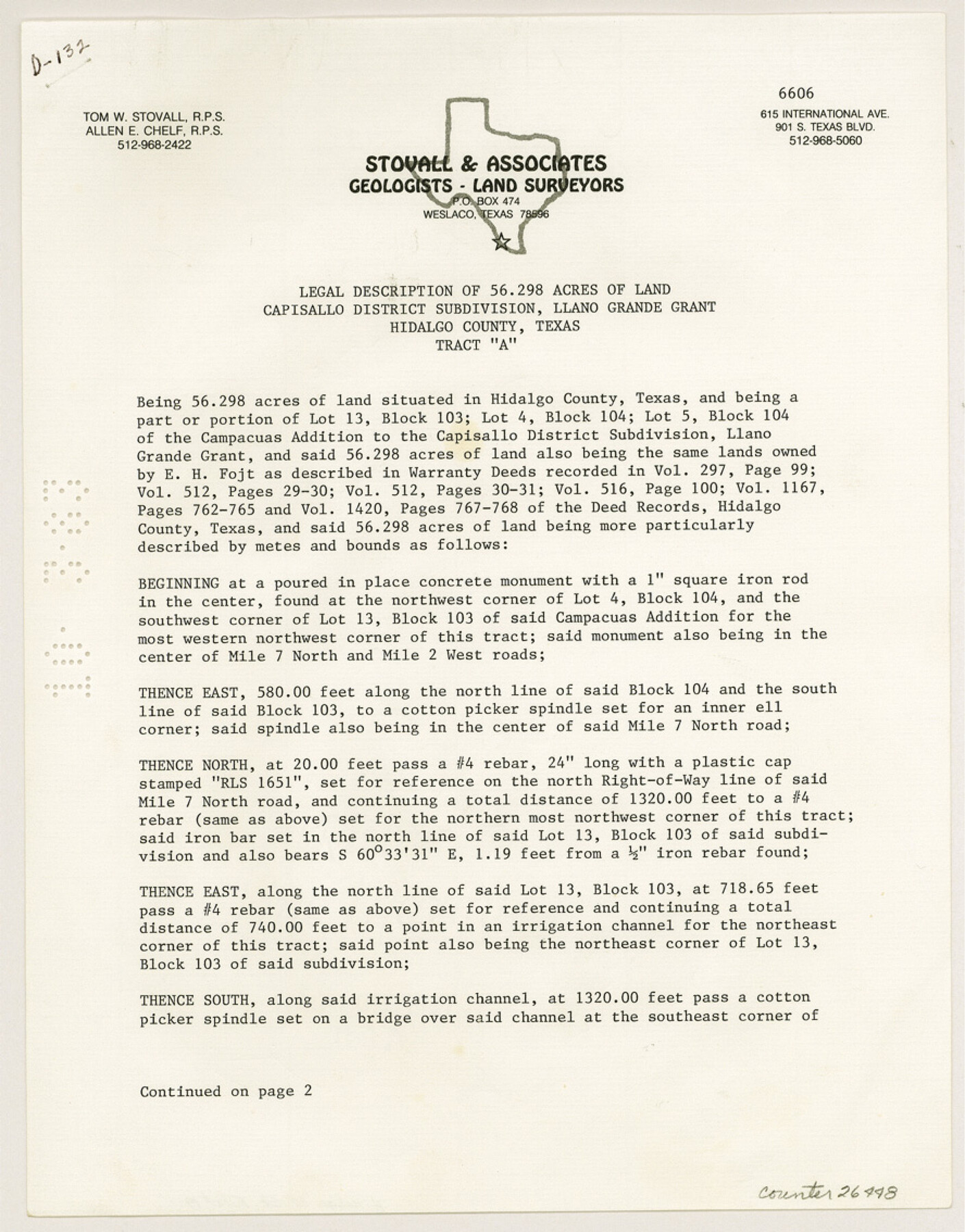
Hidalgo County Sketch File 19
56.586 ac. Tract out of Capisallo Dist. Subd. Llano Grande Grant
-
Map/Doc
26448
-
Collection
General Map Collection
-
Object Dates
10/11/1983 (Creation Date)
10/13/1983 (File Date)
9/30/1983 (Correspondence Date)
9/21/1983 (Survey Date)
-
People and Organizations
Allen E. Chelf (Surveyor/Engineer)
Tom Stovall (Surveyor/Engineer)
Chester B. Davis (Surveyor/Engineer)
S.J. Rowe (Draftsman)
-
Counties
Hidalgo Cameron
-
Subjects
Surveying Sketch File
-
Height x Width
11.3 x 8.9 inches
28.7 x 22.6 cm
-
Medium
paper, print
-
Scale
Scales differ
-
Features
Mile 7 North Road
Mile 2 West Road
Comppacuas Addition
Caisallo District Subdivision
Camparoos Lake
Arroyo de Fuste
Arroyo Colorado
Part of: General Map Collection
Dickens County Sketch File 2b

Print $14.00
- Digital $50.00
Dickens County Sketch File 2b
Size 8.8 x 13.4 inches
Map/Doc 20952
Jeff Davis County Rolled Sketch 11

Print $20.00
- Digital $50.00
Jeff Davis County Rolled Sketch 11
1914
Size 17.9 x 14.4 inches
Map/Doc 6364
Fort Bend County Sketch File 4

Print $4.00
- Digital $50.00
Fort Bend County Sketch File 4
1876
Size 10.0 x 8.4 inches
Map/Doc 22885
Map of east part of West Bay & SW part of Galveston Bay, Galveston County showing subdivision for mineral development

Print $20.00
- Digital $50.00
Map of east part of West Bay & SW part of Galveston Bay, Galveston County showing subdivision for mineral development
1951
Size 32.6 x 37.6 inches
Map/Doc 2975
Flight Mission No. DQN-2K, Frame 121, Calhoun County

Print $20.00
- Digital $50.00
Flight Mission No. DQN-2K, Frame 121, Calhoun County
1953
Size 16.3 x 16.3 inches
Map/Doc 84297
Harris County Sketch File 109

Print $16.00
- Digital $50.00
Harris County Sketch File 109
2003
Size 11.1 x 8.7 inches
Map/Doc 78506
Nueces County NRC Article 33.136 Sketch 16

Print $68.00
- Digital $50.00
Nueces County NRC Article 33.136 Sketch 16
2012
Size 22.0 x 17.0 inches
Map/Doc 94804
Stonewall County Rolled Sketch 17

Print $20.00
- Digital $50.00
Stonewall County Rolled Sketch 17
1927
Size 20.1 x 30.2 inches
Map/Doc 7871
Wilbarger County Working Sketch 14

Print $20.00
- Digital $50.00
Wilbarger County Working Sketch 14
1955
Size 24.8 x 21.7 inches
Map/Doc 72552
Williamson County Working Sketch 14

Print $20.00
- Digital $50.00
Williamson County Working Sketch 14
1982
Size 22.0 x 28.3 inches
Map/Doc 72574
Flight Mission No. DQO-11K, Frame 27, Galveston County

Print $20.00
- Digital $50.00
Flight Mission No. DQO-11K, Frame 27, Galveston County
1952
Size 18.8 x 22.4 inches
Map/Doc 85224
Mills County Sketch File 17

Print $10.00
- Digital $50.00
Mills County Sketch File 17
1912
Size 14.4 x 8.8 inches
Map/Doc 31665
You may also like
Clay County Working Sketch 8

Print $20.00
- Digital $50.00
Clay County Working Sketch 8
1937
Size 23.1 x 22.0 inches
Map/Doc 68031
Wichita County Sketch File 6

Print $40.00
- Digital $50.00
Wichita County Sketch File 6
Size 12.3 x 12.2 inches
Map/Doc 40045
Upshur County Working Sketch 5

Print $20.00
- Digital $50.00
Upshur County Working Sketch 5
1941
Size 15.0 x 20.6 inches
Map/Doc 69561
Hutchinson County Rolled Sketch 18

Print $20.00
- Digital $50.00
Hutchinson County Rolled Sketch 18
Size 30.4 x 32.6 inches
Map/Doc 9244
Dimmit County Sketch File 57

Print $6.00
- Digital $50.00
Dimmit County Sketch File 57
1941
Size 14.3 x 8.8 inches
Map/Doc 21190
Williamson County Working Sketch 4

Print $20.00
- Digital $50.00
Williamson County Working Sketch 4
1919
Size 23.7 x 19.4 inches
Map/Doc 72564
Irion County Rolled Sketch 2

Print $20.00
- Digital $50.00
Irion County Rolled Sketch 2
Size 27.8 x 39.7 inches
Map/Doc 6317
Terrell County Sketch File 20

Print $6.00
- Digital $50.00
Terrell County Sketch File 20
1910
Size 10.9 x 12.6 inches
Map/Doc 37946
Map of north end of Brazos Island

Print $20.00
- Digital $50.00
Map of north end of Brazos Island
1845
Size 24.2 x 18.3 inches
Map/Doc 72920
Brewster County Sketch File 20

Print $40.00
- Digital $50.00
Brewster County Sketch File 20
1946
Size 19.1 x 15.2 inches
Map/Doc 10979
The Rand-McNally New Commercial Atlas Map of Texas

Print $20.00
- Digital $50.00
The Rand-McNally New Commercial Atlas Map of Texas
Size 29.5 x 40.3 inches
Map/Doc 93993
Flight Mission No. DQO-8K, Frame 90, Galveston County

Print $20.00
- Digital $50.00
Flight Mission No. DQO-8K, Frame 90, Galveston County
1952
Size 17.9 x 22.3 inches
Map/Doc 85192