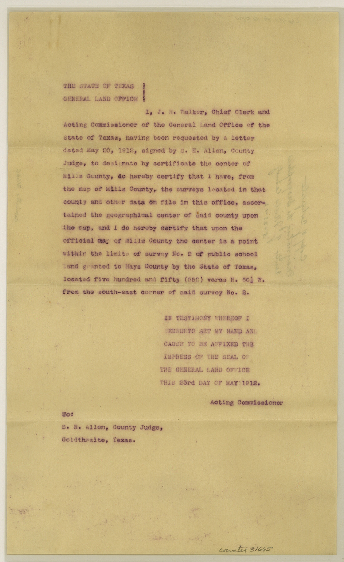
Mills County Sketch File 17
[Copy of certificate designating the geographical center of Mills County]
-
Map/Doc
31665
-
Collection
General Map Collection
-
Object Dates
5/23/1912 (Creation Date)
-
People and Organizations
J.H. Walker (Commissioner)
-
Counties
Mills
-
Subjects
Surveying Sketch File
-
Height x Width
14.4 x 8.8 inches
36.6 x 22.4 cm
-
Medium
paper, print
Part of: General Map Collection
Coke County Rolled Sketch 22

Print $20.00
- Digital $50.00
Coke County Rolled Sketch 22
1957
Size 18.2 x 22.6 inches
Map/Doc 5523
Harris County Working Sketch 1

Print $20.00
- Digital $50.00
Harris County Working Sketch 1
Size 15.8 x 15.8 inches
Map/Doc 65893
Flight Mission No. DQN-3K, Frame 37, Calhoun County

Print $20.00
- Digital $50.00
Flight Mission No. DQN-3K, Frame 37, Calhoun County
1953
Size 16.4 x 16.1 inches
Map/Doc 84350
Edwards County Rolled Sketch J

Print $83.00
- Digital $50.00
Edwards County Rolled Sketch J
1918
Size 23.6 x 30.3 inches
Map/Doc 5818
Right of Way and Track Map, the Missouri, Kansas & Texas Ry. Of Texas operated by the Missouri, Kansas & Texas Ry. Of Texas, Houston Division

Print $40.00
- Digital $50.00
Right of Way and Track Map, the Missouri, Kansas & Texas Ry. Of Texas operated by the Missouri, Kansas & Texas Ry. Of Texas, Houston Division
1918
Size 24.7 x 73.8 inches
Map/Doc 64565
Flight Mission No. CRC-3R, Frame 99, Chambers County

Print $20.00
- Digital $50.00
Flight Mission No. CRC-3R, Frame 99, Chambers County
1956
Size 18.7 x 22.4 inches
Map/Doc 84837
Atascosa County Sketch File 34

Print $4.00
- Digital $50.00
Atascosa County Sketch File 34
Size 10.4 x 8.3 inches
Map/Doc 13827
Leon County Sketch File 30

Print $6.00
- Digital $50.00
Leon County Sketch File 30
1951
Size 11.2 x 8.7 inches
Map/Doc 29829
Map of the County of Cameron

Print $40.00
- Digital $50.00
Map of the County of Cameron
1884
Size 57.0 x 33.2 inches
Map/Doc 78646
Deaf Smith County Sketch File 1b

Print $24.00
- Digital $50.00
Deaf Smith County Sketch File 1b
1902
Size 11.3 x 8.9 inches
Map/Doc 20627
Plat Showing Theoretical Original City Limits of Corpus Christi

Print $20.00
- Digital $50.00
Plat Showing Theoretical Original City Limits of Corpus Christi
Size 41.3 x 41.7 inches
Map/Doc 4838
Wilbarger County Sketch File 1

Print $4.00
- Digital $50.00
Wilbarger County Sketch File 1
Size 8.2 x 12.8 inches
Map/Doc 40162
You may also like
Clay County Sketch File 25

Print $20.00
- Digital $50.00
Clay County Sketch File 25
Size 21.1 x 16.6 inches
Map/Doc 11088
[PSL Blocks Q, U, Y, Z, W]
![90436, [PSL Blocks Q, U, Y, Z, W], Twichell Survey Records](https://historictexasmaps.com/wmedia_w700/maps/90436-1.tif.jpg)
Print $20.00
- Digital $50.00
[PSL Blocks Q, U, Y, Z, W]
Size 6.6 x 21.7 inches
Map/Doc 90436
Map of Callahan County

Print $20.00
- Digital $50.00
Map of Callahan County
1878
Size 23.0 x 18.8 inches
Map/Doc 3361
Williamson County

Print $40.00
- Digital $50.00
Williamson County
1946
Size 38.7 x 56.8 inches
Map/Doc 95676
Flight Mission No. DCL-6C, Frame 158, Kenedy County

Print $20.00
- Digital $50.00
Flight Mission No. DCL-6C, Frame 158, Kenedy County
1943
Size 15.3 x 15.2 inches
Map/Doc 85984
Angelina County

Print $40.00
- Digital $50.00
Angelina County
1945
Size 39.0 x 48.4 inches
Map/Doc 73068
Flight Mission No. DQN-7K, Frame 40, Calhoun County

Print $20.00
- Digital $50.00
Flight Mission No. DQN-7K, Frame 40, Calhoun County
1953
Size 18.5 x 22.2 inches
Map/Doc 84478
A Topographical Map of the Government Tract Adjoining the City of Austin

Print $20.00
- Digital $50.00
A Topographical Map of the Government Tract Adjoining the City of Austin
1840
Size 41.9 x 37.4 inches
Map/Doc 4842
Presidio County Sketch File 84

Print $20.00
- Digital $50.00
Presidio County Sketch File 84
1949
Size 15.2 x 37.2 inches
Map/Doc 11723
La Salle County Working Sketch 18

Print $20.00
- Digital $50.00
La Salle County Working Sketch 18
1940
Size 42.5 x 43.3 inches
Map/Doc 70319
Flight Mission No. DQN-6K, Frame 11, Calhoun County

Print $20.00
- Digital $50.00
Flight Mission No. DQN-6K, Frame 11, Calhoun County
1953
Size 18.4 x 22.2 inches
Map/Doc 84433
Gonzales County

Print $40.00
- Digital $50.00
Gonzales County
1920
Size 48.4 x 44.2 inches
Map/Doc 4706