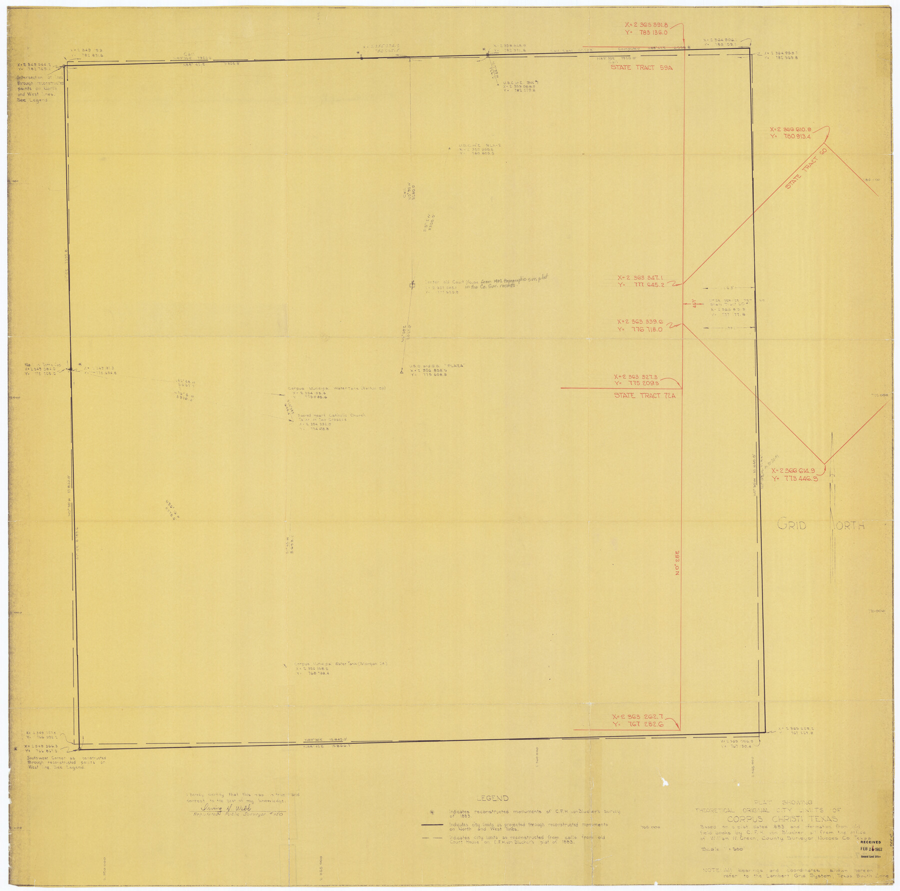
Plat Showing Theoretical Original City Limits of Corpus Christi
A-6-52
K-7-7
- 
                          Map/Doc4838
- 
                            CollectionGeneral Map Collection
- 
                            People and OrganizationsIrving H. Webb (Surveyor/Engineer)William W. Green (Surveyor/Engineer)C.F.H. von Blucher (Surveyor/Engineer)
- 
                            CountiesNueces
- 
                            SubjectsCity
- 
                            Height x Width41.3 x 41.7 inches104.9 x 105.9 cm
- 
                            CommentsBased on a plat dated 1883 and information from old field books by C. F. H. von Blucher
Part of: General Map Collection
            Map of Jackson County Texas


                                            Print $20.00                    
                                             -                         Digital $50.00                                    
                Map of Jackson County Texas
1840
Size 29.6 x 23.2 inches
                                Map/Doc 3708
            
            Garza County Sketch File 25


                                            Print $4.00                    
                                             -                         Digital $50.00                                    
                Garza County Sketch File 25
1907
Size 7.6 x 7.9 inches
                                Map/Doc 24086
            
            Victoria County Sketch File 5a


                                            Print $2.00                    
                                             -                         Digital $50.00                                    
                Victoria County Sketch File 5a
Size 8.2 x 12.9 inches
                                Map/Doc 39522
            
            Presidio County Rolled Sketch S1


                                            Print $20.00                    
                                             -                         Digital $50.00                                    
                Presidio County Rolled Sketch S1
Size 13.3 x 18.8 inches
                                Map/Doc 7414
            
            Gaines County Boundary File 4


                                            Print $4.00                    
                                             -                         Digital $50.00                                    
                Gaines County Boundary File 4
Size 14.4 x 8.9 inches
                                Map/Doc 53656
            
            Edwards County Working Sketch 98


                                            Print $20.00                    
                                             -                         Digital $50.00                                    
                Edwards County Working Sketch 98
1970
Size 35.1 x 37.6 inches
                                Map/Doc 68974
            
            Garza County Working Sketch 9


                                            Print $20.00                    
                                             -                         Digital $50.00                                    
                Garza County Working Sketch 9
1952
Size 15.7 x 18.0 inches
                                Map/Doc 63156
            
            Floyd County Sketch File 8


                                            Print $40.00                    
                                             -                         Digital $50.00                                    
                Floyd County Sketch File 8
1878
Map/Doc 93784
            
            Brazoria County Working Sketch 29


                                            Print $20.00                    
                                             -                         Digital $50.00                                    
                Brazoria County Working Sketch 29
1971
Size 30.6 x 28.3 inches
                                Map/Doc 67514
            
            Coast Chart No. 211 - Padre I. and Laguna Madre Lat. 27° 12' to Lat. 26° 33' Texas


                                            Print $20.00                    
                                             -                         Digital $50.00                                    
                Coast Chart No. 211 - Padre I. and Laguna Madre Lat. 27° 12' to Lat. 26° 33' Texas
1890
Size 27.5 x 18.2 inches
                                Map/Doc 72822
            
            [Surveys along the Salado and Lampasas Rivers and Saltillo Creek]
            
                                    ![82159, [Surveys along the Salado and Lampasas Rivers and Saltillo Creek], General Map Collection](https://historictexasmaps.com/wmedia_w700/maps/82159.tif.jpg) 


    ![82159, [Surveys along the Salado and Lampasas Rivers and Saltillo Creek], General Map Collection](https://historictexasmaps.com/wmedia_w700/maps/82159.tif.jpg) 
                                
            
                                            Print $2.00                    
                                             -                         Digital $50.00                                    
                [Surveys along the Salado and Lampasas Rivers and Saltillo Creek]
1845
Size 13.1 x 7.7 inches
                                Map/Doc 82159
            
            Galveston County NRC Article 33.136 Location Key Sheet


                                            Print $20.00                    
                                             -                         Digital $50.00                                    
                Galveston County NRC Article 33.136 Location Key Sheet
1995
Size 27.0 x 22.0 inches
                                Map/Doc 83001
            You may also like
            Culberson County Sketch File 42


                                            Print $14.00                    
                                             -                         Digital $50.00                                    
                Culberson County Sketch File 42
1966
Size 14.2 x 8.7 inches
                                Map/Doc 20322
            
            Panola County Rolled Sketch 8


                                            Print $20.00                    
                                             -                         Digital $50.00                                    
                Panola County Rolled Sketch 8
1986
Size 20.1 x 18.0 inches
                                Map/Doc 7201
            
            [Leagues along West line of County]
            
                                    ![90547, [Leagues along West line of County], Twichell Survey Records](https://historictexasmaps.com/wmedia_w700/maps/90547-1.tif.jpg) 


    ![90547, [Leagues along West line of County], Twichell Survey Records](https://historictexasmaps.com/wmedia_w700/maps/90547-1.tif.jpg) 
                                
            
                                            Print $2.00                    
                                             -                         Digital $50.00                                    
                [Leagues along West line of County]
Size 5.7 x 11.6 inches
                                Map/Doc 90547
            
            Mappa Geographica Regionem Mexicanam et Floridam, Terrasque adjacentes, ut et Anteriores Americae Insulas, Curfus itidem et Reditus Navigantuim verfus flumen Missisipi et alias Colonias ob oculos ponens, cura et fumptibus


                                            Print $20.00                    
                                    
                Mappa Geographica Regionem Mexicanam et Floridam, Terrasque adjacentes, ut et Anteriores Americae Insulas, Curfus itidem et Reditus Navigantuim verfus flumen Missisipi et alias Colonias ob oculos ponens, cura et fumptibus
1725
Size 20.0 x 24.0 inches
                                Map/Doc 76196
            
            Knox County Sketch File 28


                                            Print $20.00                    
                                             -                         Digital $50.00                                    
                Knox County Sketch File 28
Size 43.4 x 38.3 inches
                                Map/Doc 10516
            
            Map of Andrews County


                                            Print $40.00                    
                                             -                         Digital $50.00                                    
                Map of Andrews County
1900
Size 40.8 x 52.9 inches
                                Map/Doc 4780
            
            Liberty County Sketch File 33


                                            Print $4.00                    
                                             -                         Digital $50.00                                    
                Liberty County Sketch File 33
Size 10.7 x 7.8 inches
                                Map/Doc 29967
            
            Pecos County Working Sketch 137


                                            Print $20.00                    
                                             -                         Digital $50.00                                    
                Pecos County Working Sketch 137
1981
Size 32.3 x 28.4 inches
                                Map/Doc 71611
            
            Pecos County Working Sketch 26


                                            Print $20.00                    
                                             -                         Digital $50.00                                    
                Pecos County Working Sketch 26
1929
Size 27.6 x 28.6 inches
                                Map/Doc 71497
            
            J. B. Chilton's Subdivision of League 289, Gaines County, Texas


                                            Print $20.00                    
                                             -                         Digital $50.00                                    
                J. B. Chilton's Subdivision of League 289, Gaines County, Texas
1924
Size 18.7 x 24.7 inches
                                Map/Doc 92682
            
            Real County Working Sketch 7


                                            Print $20.00                    
                                             -                         Digital $50.00                                    
                Real County Working Sketch 7
1928
Size 18.4 x 19.4 inches
                                Map/Doc 71899
            
            Outer Continental Shelf Leasing Maps (Texas Offshore Operations)


                                            Print $20.00                    
                                             -                         Digital $50.00                                    
                Outer Continental Shelf Leasing Maps (Texas Offshore Operations)
Size 29.9 x 21.7 inches
                                Map/Doc 75857
            