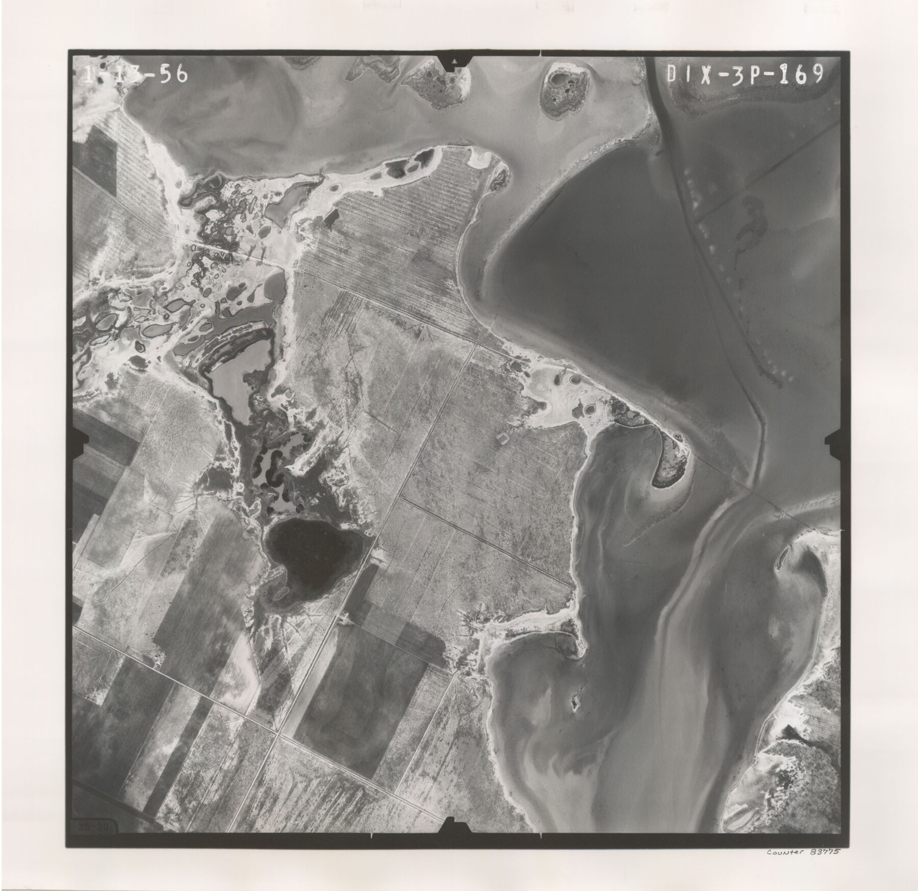
Flight Mission No. DIX-3P, Frame 169, Aransas County
DIX-3P-169
-
Map/Doc
83775
-
Collection
General Map Collection
-
Object Dates
1956/1/13 (Creation Date)
-
People and Organizations
U. S. Department of Agriculture (Publisher)
-
Counties
Aransas
-
Subjects
Aerial Photograph
-
Height x Width
17.8 x 18.3 inches
45.2 x 46.5 cm
-
Comments
Flown by V. L. Beavers and Associates of San Antonio, Texas.
Part of: General Map Collection
Crane County Sketch File 14 (C-2)

Print $8.00
- Digital $50.00
Crane County Sketch File 14 (C-2)
1925
Size 9.3 x 7.7 inches
Map/Doc 19575
Flight Mission No. DIX-6P, Frame 110, Aransas County

Print $20.00
- Digital $50.00
Flight Mission No. DIX-6P, Frame 110, Aransas County
1956
Size 19.7 x 23.4 inches
Map/Doc 83816
Map of Matagorda Bay and County with the Adjacent Country

Print $20.00
- Digital $50.00
Map of Matagorda Bay and County with the Adjacent Country
1839
Size 33.4 x 42.6 inches
Map/Doc 2002
Upton County Rolled Sketch 34

Print $20.00
- Digital $50.00
Upton County Rolled Sketch 34
1951
Size 34.4 x 34.3 inches
Map/Doc 10050
Maps of Gulf Intracoastal Waterway, Texas - Sabine River to the Rio Grande and connecting waterways including ship channels

Print $20.00
- Digital $50.00
Maps of Gulf Intracoastal Waterway, Texas - Sabine River to the Rio Grande and connecting waterways including ship channels
1966
Size 14.5 x 22.3 inches
Map/Doc 61949
Reagan County Rolled Sketch 34

Print $40.00
- Digital $50.00
Reagan County Rolled Sketch 34
1956
Size 53.2 x 40.3 inches
Map/Doc 9829
Culberson County Rolled Sketch 41

Print $88.00
- Digital $50.00
Culberson County Rolled Sketch 41
1944
Size 57.5 x 46.0 inches
Map/Doc 8752
[Map of Block 97, Borden and Scurry Co (Exhibit A); Map of Southeastern part of Young Territory; Map of part of of Borden, Fisher, Kent, Mitchell, Scurry and Garza Cos. Showing the north boundary line of the T&P 80 mile reservation]
![65693, [Map of Block 97, Borden and Scurry Co (Exhibit A); Map of Southeastern part of Young Territory; Map of part of of Borden, Fisher, Kent, Mitchell, Scurry and Garza Cos. Showing the north boundary line of the T&P 80 mile reservation], General Map Collection](https://historictexasmaps.com/wmedia_w700/maps/65693.tif.jpg)
Print $20.00
- Digital $50.00
[Map of Block 97, Borden and Scurry Co (Exhibit A); Map of Southeastern part of Young Territory; Map of part of of Borden, Fisher, Kent, Mitchell, Scurry and Garza Cos. Showing the north boundary line of the T&P 80 mile reservation]
1901
Size 31.2 x 23.3 inches
Map/Doc 65693
Pecos County Working Sketch 100

Print $20.00
- Digital $50.00
Pecos County Working Sketch 100
1970
Size 42.9 x 31.6 inches
Map/Doc 71573
Texas 1972 Official Highway Travel Map

Digital $50.00
Texas 1972 Official Highway Travel Map
Size 28.2 x 36.4 inches
Map/Doc 94314
Burleson County Working Sketch 17

Print $20.00
- Digital $50.00
Burleson County Working Sketch 17
1980
Size 20.5 x 37.6 inches
Map/Doc 67736
Atascosa County Sketch File 16

Print $4.00
- Digital $50.00
Atascosa County Sketch File 16
1877
Size 12.2 x 7.9 inches
Map/Doc 13779
You may also like
Goliad County Rolled Sketch 5

Print $20.00
- Digital $50.00
Goliad County Rolled Sketch 5
1956
Size 26.5 x 29.5 inches
Map/Doc 6025
Bravo Ranch situated in Hartley and Oldham Counties, Texas

Print $40.00
- Digital $50.00
Bravo Ranch situated in Hartley and Oldham Counties, Texas
Size 38.8 x 51.3 inches
Map/Doc 89930
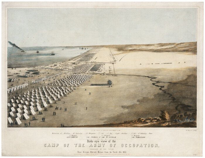
Birds-eye view of the camp of the army of occupation commanded by Genl. Taylor near Corpus Christi, Texas (from the North)
Print $20.00
- Digital $50.00
Birds-eye view of the camp of the army of occupation commanded by Genl. Taylor near Corpus Christi, Texas (from the North)
1847
Size 15.8 x 20.5 inches
Map/Doc 95951
Taylor County

Print $20.00
- Digital $50.00
Taylor County
1934
Size 44.4 x 38.9 inches
Map/Doc 73299
[Meander of Yellow House Creek from Northeast Corner of Section 37, Block S to Northeast corner of Section 3, Block O]
![91387, [Meander of Yellow House Creek from Northeast Corner of Section 37, Block S to Northeast corner of Section 3, Block O], Twichell Survey Records](https://historictexasmaps.com/wmedia_w700/maps/91387-1.tif.jpg)
Print $20.00
- Digital $50.00
[Meander of Yellow House Creek from Northeast Corner of Section 37, Block S to Northeast corner of Section 3, Block O]
Size 24.8 x 32.7 inches
Map/Doc 91387
King County Sketch File 11

Print $40.00
- Digital $50.00
King County Sketch File 11
1902
Size 13.7 x 9.1 inches
Map/Doc 29085
Comal County Sketch File 10

Print $4.00
- Digital $50.00
Comal County Sketch File 10
1849
Size 12.7 x 7.6 inches
Map/Doc 19020
Flight Mission No. DQN-2K, Frame 163, Calhoun County

Print $20.00
- Digital $50.00
Flight Mission No. DQN-2K, Frame 163, Calhoun County
1953
Size 18.5 x 22.2 inches
Map/Doc 84325
Phelps and Watson's Historical and Military Map of the Border and Southern States

Print $20.00
Phelps and Watson's Historical and Military Map of the Border and Southern States
1863
Size 25.5 x 36.3 inches
Map/Doc 76202
Flight Mission No. DAG-23K, Frame 167, Matagorda County

Print $20.00
- Digital $50.00
Flight Mission No. DAG-23K, Frame 167, Matagorda County
1953
Size 15.9 x 19.1 inches
Map/Doc 86505
Polk County Working Sketch 13

Print $20.00
- Digital $50.00
Polk County Working Sketch 13
1942
Size 17.1 x 20.6 inches
Map/Doc 71628
Freestone County Sketch File 12

Print $6.00
- Digital $50.00
Freestone County Sketch File 12
Size 8.2 x 6.3 inches
Map/Doc 23060