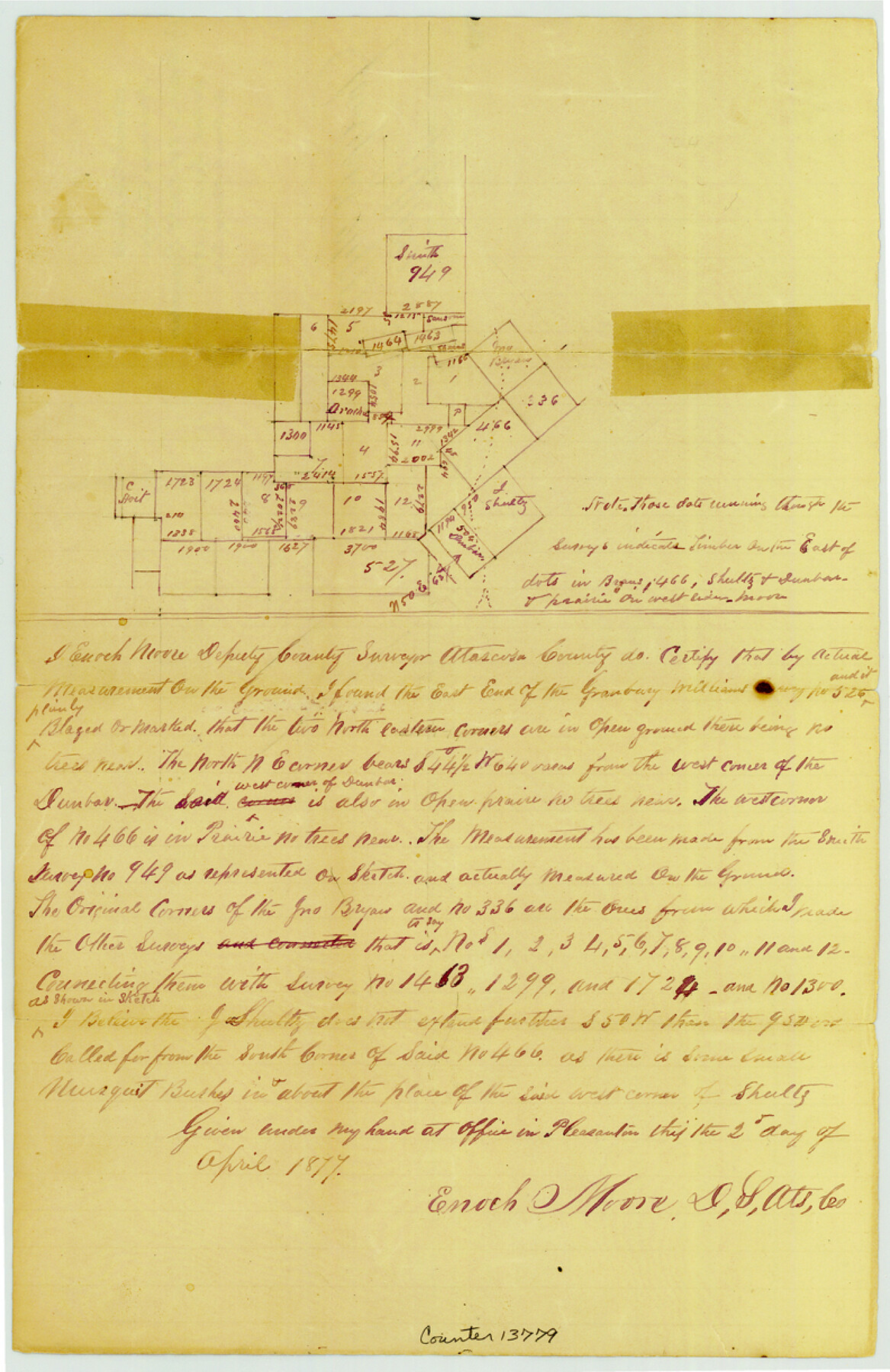
Atascosa County Sketch File 16
[Sketch of surveys along or near Metate Creek]
-
Map/Doc
13779
-
Collection
General Map Collection
-
Object Dates
1877/4/2 (Creation Date)
1877/4/24 (File Date)
-
People and Organizations
Enoch Moore (Surveyor/Engineer)
-
Counties
Atascosa
-
Subjects
Surveying Sketch File
-
Height x Width
12.2 x 7.9 inches
31.0 x 20.1 cm
-
Medium
paper, manuscript
Part of: General Map Collection
Chambers County Sketch File 4

Print $40.00
- Digital $50.00
Chambers County Sketch File 4
1859
Size 25.8 x 8.8 inches
Map/Doc 17521
Lamb County Rolled Sketch 3

Print $20.00
- Digital $50.00
Lamb County Rolled Sketch 3
1917
Size 23.0 x 42.5 inches
Map/Doc 9413
Hutchinson County Rolled Sketch 40

Print $20.00
- Digital $50.00
Hutchinson County Rolled Sketch 40
1981
Size 26.2 x 37.4 inches
Map/Doc 6305
Harris County Sketch File 78

Print $32.00
- Digital $50.00
Harris County Sketch File 78
1955
Size 8.7 x 9.0 inches
Map/Doc 25549
Orange County Sketch File 32

Print $6.00
- Digital $50.00
Orange County Sketch File 32
1926
Size 14.3 x 8.7 inches
Map/Doc 33360
Van Zandt County Sketch File 28

Print $4.00
- Digital $50.00
Van Zandt County Sketch File 28
1859
Size 12.5 x 8.2 inches
Map/Doc 39451

Uvalde County Working Sketch 32

Print $20.00
- Digital $50.00
Uvalde County Working Sketch 32
1962
Size 27.2 x 41.8 inches
Map/Doc 72102
Panola County Sketch File 6

Print $4.00
- Digital $50.00
Panola County Sketch File 6
1862
Size 7.9 x 5.0 inches
Map/Doc 33455
General Land Office and State Reclamation Department - An Index Map

Print $20.00
- Digital $50.00
General Land Office and State Reclamation Department - An Index Map
1930
Size 26.2 x 16.6 inches
Map/Doc 65069
Hudspeth County Rolled Sketch 14

Print $20.00
- Digital $50.00
Hudspeth County Rolled Sketch 14
1885
Size 17.1 x 35.9 inches
Map/Doc 9202
Anderson County Working Sketch 2

Print $20.00
- Digital $50.00
Anderson County Working Sketch 2
Size 31.8 x 37.7 inches
Map/Doc 67001
You may also like
Plano del Presidio de Bahia dela Espiritu Santo dependite dela Governacion de los Tejas situado en 29 grad. Y 39 min. de latitud boreal y 277° y 54' dela long. contados desde el Merid. De Tenerife

Plano del Presidio de Bahia dela Espiritu Santo dependite dela Governacion de los Tejas situado en 29 grad. Y 39 min. de latitud boreal y 277° y 54' dela long. contados desde el Merid. De Tenerife
1768
Size 16.7 x 21.0 inches
Map/Doc 96565
Kinney County Working Sketch 6

Print $20.00
- Digital $50.00
Kinney County Working Sketch 6
1908
Size 19.6 x 23.9 inches
Map/Doc 70188
Flight Mission No. DAG-14K, Frame 133, Matagorda County

Print $20.00
- Digital $50.00
Flight Mission No. DAG-14K, Frame 133, Matagorda County
1952
Size 17.6 x 17.4 inches
Map/Doc 86304
Aransas County Sketch File 37

Print $139.00
- Digital $50.00
Aransas County Sketch File 37
1995
Size 11.1 x 9.1 inches
Map/Doc 13413
Montgomery County Rolled Sketch 30

Print $40.00
- Digital $50.00
Montgomery County Rolled Sketch 30
1949
Size 34.6 x 51.3 inches
Map/Doc 9538
Refugio County Sketch File 26

Print $4.00
- Digital $50.00
Refugio County Sketch File 26
Size 12.9 x 8.4 inches
Map/Doc 35292
Van Zandt County Sketch File 32

Print $4.00
- Digital $50.00
Van Zandt County Sketch File 32
1860
Size 12.2 x 7.9 inches
Map/Doc 39465
Hudspeth County Rolled Sketch 75

Print $40.00
- Digital $50.00
Hudspeth County Rolled Sketch 75
1992
Size 35.6 x 48.9 inches
Map/Doc 9238
General Highway Map, Floyd County, Texas

Print $20.00
General Highway Map, Floyd County, Texas
1940
Size 25.1 x 18.7 inches
Map/Doc 79091
Starr County Working Sketch Graphic Index

Print $40.00
- Digital $50.00
Starr County Working Sketch Graphic Index
1977
Size 43.0 x 55.5 inches
Map/Doc 76701
Burnet County Rolled Sketch 5

Print $40.00
- Digital $50.00
Burnet County Rolled Sketch 5
1971
Size 36.5 x 49.6 inches
Map/Doc 8542
Hale County Sketch File 18

Print $4.00
- Digital $50.00
Hale County Sketch File 18
1903
Size 11.0 x 8.6 inches
Map/Doc 24749