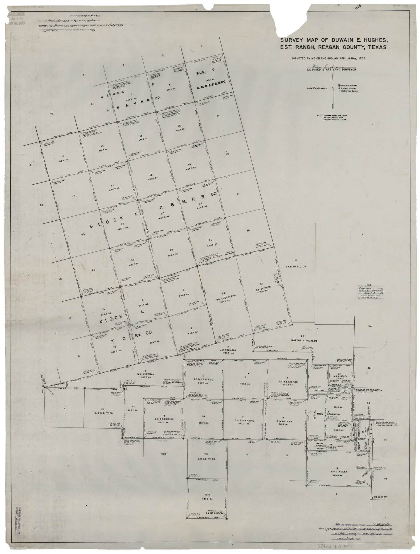
Reagan County Rolled Sketch 34
Survey map of Duwain E. Hughes, Est. Ranch, Reagan County, Texas
-
Map/Doc
9829
-
Collection
General Map Collection
-
Object Dates
1956 (Creation Date)
1956/9/4 (File Date)
-
People and Organizations
Byron L. Simpson (Surveyor/Engineer)
-
Counties
Reagan
-
Subjects
Surveying Rolled Sketch
-
Height x Width
53.2 x 40.3 inches
135.1 x 102.4 cm
-
Medium
mylar, print
-
Scale
1" = 500 varas
Part of: General Map Collection
Township No. 5 South Range No. 12 West of the Indian Meridian

Print $4.00
- Digital $50.00
Township No. 5 South Range No. 12 West of the Indian Meridian
1875
Size 18.1 x 22.6 inches
Map/Doc 75159
Red River County Working Sketch 3

Print $20.00
- Digital $50.00
Red River County Working Sketch 3
1919
Size 14.2 x 12.8 inches
Map/Doc 71986
Duval County Sketch File 59

Print $6.00
- Digital $50.00
Duval County Sketch File 59
1940
Size 14.4 x 9.0 inches
Map/Doc 21425
Archer County Working Sketch 25

Print $20.00
- Digital $50.00
Archer County Working Sketch 25
Size 24.9 x 33.1 inches
Map/Doc 78188
Flight Mission No. BQR-13K, Frame 122, Brazoria County

Print $20.00
- Digital $50.00
Flight Mission No. BQR-13K, Frame 122, Brazoria County
1952
Size 18.6 x 22.3 inches
Map/Doc 84083
Flight Mission No. CRE-3R, Frame 38, Jackson County

Print $20.00
- Digital $50.00
Flight Mission No. CRE-3R, Frame 38, Jackson County
1956
Size 18.6 x 22.2 inches
Map/Doc 85384
Edwards County Working Sketch 90

Print $20.00
- Digital $50.00
Edwards County Working Sketch 90
1966
Size 33.6 x 27.2 inches
Map/Doc 68966
Montague County Sketch File 14

Print $4.00
- Digital $50.00
Montague County Sketch File 14
1880
Size 7.8 x 5.4 inches
Map/Doc 31740
Map of Webb County

Print $20.00
- Digital $50.00
Map of Webb County
1895
Size 34.8 x 27.0 inches
Map/Doc 4132
Kleberg County Rolled Sketch 10-11

Print $20.00
- Digital $50.00
Kleberg County Rolled Sketch 10-11
1951
Size 38.2 x 33.8 inches
Map/Doc 9374
Brewster County Sketch File 16

Print $46.00
- Digital $50.00
Brewster County Sketch File 16
1936
Size 14.3 x 8.6 inches
Map/Doc 15777
Maverick County Working Sketch 17

Print $20.00
- Digital $50.00
Maverick County Working Sketch 17
1975
Size 28.8 x 31.4 inches
Map/Doc 70909
You may also like
United States - Gulf Coast - From Latitude 26° 33' to the Rio Grande Texas

Print $20.00
- Digital $50.00
United States - Gulf Coast - From Latitude 26° 33' to the Rio Grande Texas
1913
Size 18.3 x 23.6 inches
Map/Doc 72844
Navarro County Working Sketch 2

Print $20.00
- Digital $50.00
Navarro County Working Sketch 2
1922
Size 21.9 x 22.2 inches
Map/Doc 71232
Haskell County Rolled Sketch 10

Print $20.00
- Digital $50.00
Haskell County Rolled Sketch 10
1981
Size 33.2 x 14.3 inches
Map/Doc 6169
Mason County Working Sketch 21

Print $20.00
- Digital $50.00
Mason County Working Sketch 21
1945
Size 37.1 x 43.2 inches
Map/Doc 70857
Subdivision Map of Childress County School Land situated in Bailey and Cochran Counties, Tex.

Print $20.00
- Digital $50.00
Subdivision Map of Childress County School Land situated in Bailey and Cochran Counties, Tex.
Size 22.8 x 26.2 inches
Map/Doc 90200
[Survey 1, Block MT, and vicinity]
![90683, [Survey 1, Block MT, and vicinity], Twichell Survey Records](https://historictexasmaps.com/wmedia_w700/maps/90683-1.tif.jpg)
Print $3.00
- Digital $50.00
[Survey 1, Block MT, and vicinity]
1903
Size 11.1 x 14.6 inches
Map/Doc 90683
Post Route Map of the State of Texas with Adjacent Parts of Louisiana, Arkansas, Indian Territory and the Republic of Mexico Showing Post Offices with the Intermediate Distances and Mail Routes in Operation on the 1st of April 1891

Print $40.00
Post Route Map of the State of Texas with Adjacent Parts of Louisiana, Arkansas, Indian Territory and the Republic of Mexico Showing Post Offices with the Intermediate Distances and Mail Routes in Operation on the 1st of April 1891
1891
Size 44.5 x 58.2 inches
Map/Doc 89061
Gillespie County Sketch File 3

Print $4.00
- Digital $50.00
Gillespie County Sketch File 3
1847
Size 11.2 x 8.0 inches
Map/Doc 24129
[Surveys in Austin's Colony along the east bank of the Navidad River]
![78488, [Surveys in Austin's Colony along the east bank of the Navidad River], General Map Collection](https://historictexasmaps.com/wmedia_w700/maps/78488.tif.jpg)
Print $20.00
- Digital $50.00
[Surveys in Austin's Colony along the east bank of the Navidad River]
1827
Size 20.3 x 16.1 inches
Map/Doc 78488

General Highway Map, Llano County, Texas

Print $20.00
General Highway Map, Llano County, Texas
1940
Size 18.4 x 24.9 inches
Map/Doc 79178
Houston County Sketch File 5a

Print $5.00
- Digital $50.00
Houston County Sketch File 5a
Size 8.5 x 9.4 inches
Map/Doc 26758