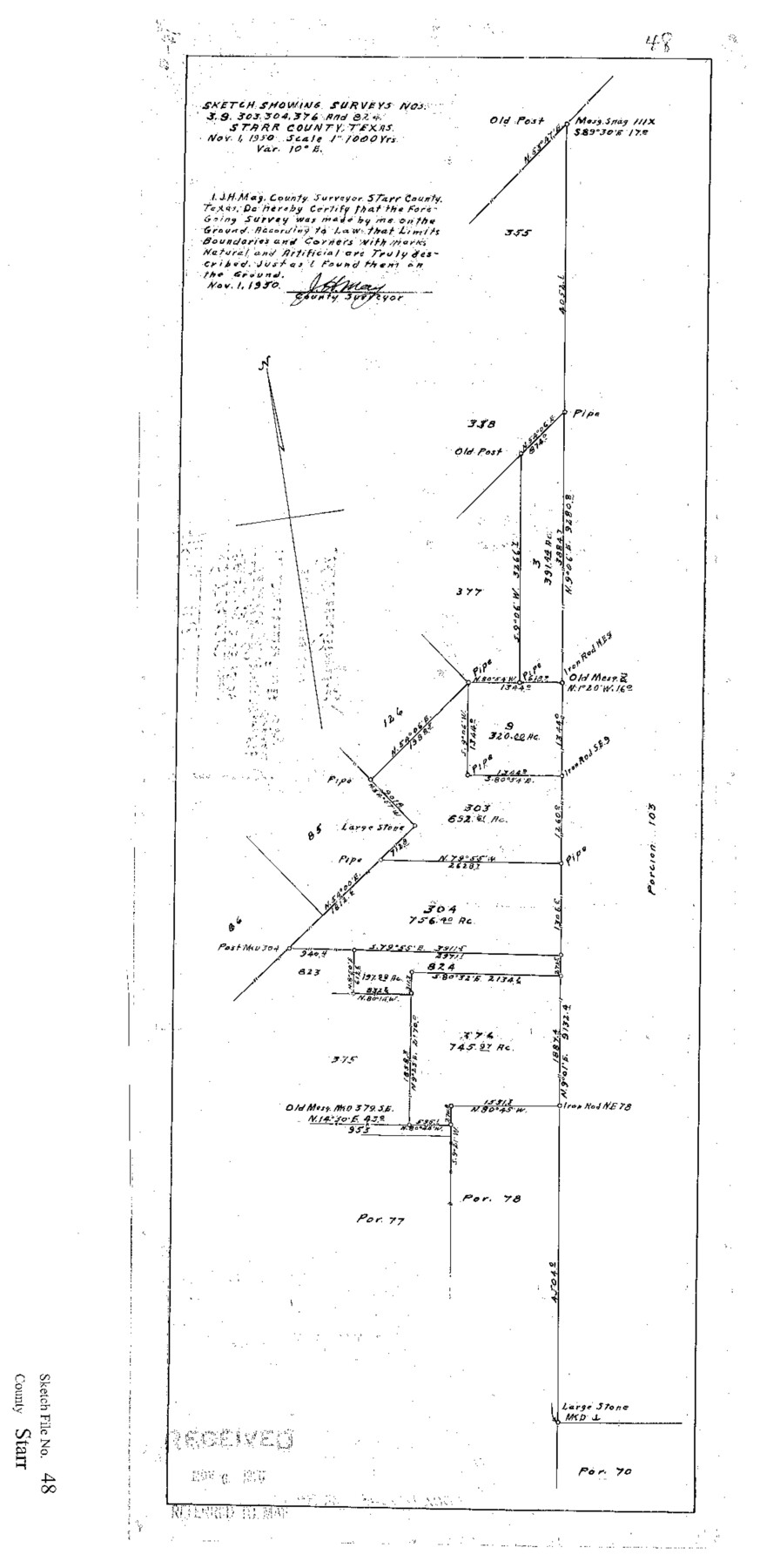
Starr County Sketch File 48
Sketch showing surveys nos. 3, 9, 303, 304, 376, and 824, Starr County, Texas
- 
                          Map/Doc12345
- 
                            CollectionGeneral Map Collection
- 
                            Object Dates11/1/1950 (Creation Date)11/9/1950 (File Date)
- 
                            People and OrganizationsJ.H. May (Surveyor/Engineer)
- 
                            CountiesStarr
- 
                            SubjectsSurveying Sketch File
- 
                            Height x Width22.3 x 10.8 inches56.6 x 27.4 cm
- 
                            Mediumpaper, print
- 
                            Scale1" = 1000 varas
Part of: General Map Collection
            Kaufman County Sketch File 5


                                            Print $22.00                    
                                             -                         Digital $50.00                                    
                Kaufman County Sketch File 5
1849
Size 7.6 x 12.6 inches
                                Map/Doc 28632
            
            Gonzales County Boundary File 1b


                                            Print $52.00                    
                                             -                         Digital $50.00                                    
                Gonzales County Boundary File 1b
Size 8.0 x 5.0 inches
                                Map/Doc 53803
            
            Dickens County Sketch File 6a


                                            Print $6.00                    
                                             -                         Digital $50.00                                    
                Dickens County Sketch File 6a
1882
Size 16.5 x 9.4 inches
                                Map/Doc 20969
            
            Stephens County Texas


                                            Print $20.00                    
                                             -                         Digital $50.00                                    
                Stephens County Texas
Size 20.8 x 18.6 inches
                                Map/Doc 4627
            
            Dallas County Boundary File 6d


                                            Print $104.00                    
                                             -                         Digital $50.00                                    
                Dallas County Boundary File 6d
Size 14.2 x 8.6 inches
                                Map/Doc 52229
            
            Terrell County Working Sketch 13


                                            Print $20.00                    
                                             -                         Digital $50.00                                    
                Terrell County Working Sketch 13
1926
Size 30.1 x 22.8 inches
                                Map/Doc 62162
            
            Matagorda County Sketch File 7


                                            Print $20.00                    
                                             -                         Digital $50.00                                    
                Matagorda County Sketch File 7
1890
Size 37.3 x 24.6 inches
                                Map/Doc 12038
            
            Flight Mission No. CRC-3R, Frame 99, Chambers County


                                            Print $20.00                    
                                             -                         Digital $50.00                                    
                Flight Mission No. CRC-3R, Frame 99, Chambers County
1956
Size 18.7 x 22.4 inches
                                Map/Doc 84837
            
            Jefferson Co.


                                            Print $40.00                    
                                             -                         Digital $50.00                                    
                Jefferson Co.
1978
Size 49.3 x 43.5 inches
                                Map/Doc 95546
            
            Coryell County Sketch File 10


                                            Print $6.00                    
                                             -                         Digital $50.00                                    
                Coryell County Sketch File 10
1861
Size 8.6 x 7.2 inches
                                Map/Doc 19361
            
            Childress County Sketch File 12


                                            Print $22.00                    
                                             -                         Digital $50.00                                    
                Childress County Sketch File 12
Size 13.3 x 8.7 inches
                                Map/Doc 18255
            You may also like
            Mapa de los Estados Unidos Mejicanos arreglado a la distribucion que en diversos decretos ha hecho del territorio el Congreso General Mejicano


                                            Print $20.00                    
                                             -                         Digital $50.00                                    
                Mapa de los Estados Unidos Mejicanos arreglado a la distribucion que en diversos decretos ha hecho del territorio el Congreso General Mejicano
Size 24.6 x 30.3 inches
                                Map/Doc 96514
            
            Howard County Boundary File 2b


                                            Print $8.00                    
                                             -                         Digital $50.00                                    
                Howard County Boundary File 2b
Size 11.4 x 8.8 inches
                                Map/Doc 55122
            
            Oldham County Sketch File 1


                                            Print $24.00                    
                                             -                         Digital $50.00                                    
                Oldham County Sketch File 1
1880
Size 12.6 x 7.9 inches
                                Map/Doc 33213
            
            [Surveys in the Jefferson District]
            
                                    ![69726, [Surveys in the Jefferson District], General Map Collection](https://historictexasmaps.com/wmedia_w700/maps/69726-1.tif.jpg) 


    ![69726, [Surveys in the Jefferson District], General Map Collection](https://historictexasmaps.com/wmedia_w700/maps/69726-1.tif.jpg) 
                                
            
                                            Print $20.00                    
                                             -                         Digital $50.00                                    
                [Surveys in the Jefferson District]
1841
Size 14.6 x 21.2 inches
                                Map/Doc 69726
            
            [Gulf Coast of Texas]
            
                                    ![72703, [Gulf Coast of Texas], General Map Collection](https://historictexasmaps.com/wmedia_w700/maps/72703.tif.jpg) 


    ![72703, [Gulf Coast of Texas], General Map Collection](https://historictexasmaps.com/wmedia_w700/maps/72703.tif.jpg) 
                                
            
                                            Print $20.00                    
                                             -                         Digital $50.00                                    
                [Gulf Coast of Texas]
1881
Size 28.9 x 18.2 inches
                                Map/Doc 72703
            
            United States - Gulf Coast - From Latitude 26° 33' to the Rio Grande Texas


                                            Print $20.00                    
                                             -                         Digital $50.00                                    
                United States - Gulf Coast - From Latitude 26° 33' to the Rio Grande Texas
1913
Size 27.9 x 18.2 inches
                                Map/Doc 72832
            
            Map of San Saba County


                                            Print $20.00                    
                                             -                         Digital $50.00                                    
                Map of San Saba County
1858
Size 21.6 x 23.5 inches
                                Map/Doc 4019
            
            Right of Way and Track Map, the Missouri, Kansas and Texas Ry. of Texas - Henrietta Division


                                            Print $20.00                    
                                             -                         Digital $50.00                                    
                Right of Way and Track Map, the Missouri, Kansas and Texas Ry. of Texas - Henrietta Division
1918
Size 11.8 x 26.8 inches
                                Map/Doc 64750
            
            Milam County Working Sketch Graphic Index


                                            Print $40.00                    
                                             -                         Digital $50.00                                    
                Milam County Working Sketch Graphic Index
1975
Size 51.6 x 42.7 inches
                                Map/Doc 76642
            
            Traveller's Map of the State of Texas


                                            Print $20.00                    
                                             -                         Digital $50.00                                    
                Traveller's Map of the State of Texas
1867
Size 40.7 x 38.7 inches
                                Map/Doc 2130
            
            Plan of the City of Indianola, Texas


                                            Print $40.00                    
                                             -                         Digital $50.00                                    
                Plan of the City of Indianola, Texas
1868
Size 37.5 x 55.3 inches
                                Map/Doc 4835
            
            Uvalde County


                                            Print $20.00                    
                                             -                         Digital $50.00                                    
                Uvalde County
1976
Size 42.7 x 46.4 inches
                                Map/Doc 73310
             
                            