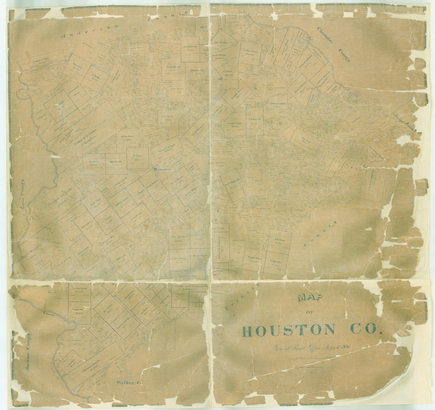
Map of Houston Co.
-
Map/Doc
4688
-
Collection
General Map Collection
-
Object Dates
1896/5/5 (Creation Date)
-
People and Organizations
Texas General Land Office (Publisher)
C.M. Hill (Compiler)
J.F. Clark (Draftsman)
-
Counties
Houston
-
Subjects
County
-
Height x Width
46.2 x 49.0 inches
117.3 x 124.5 cm
-
Features
Pine Creek
Bidais Creek
Negro Creek
Randolph
Robbins Ferry
Lost Creek
Mustang Creek
Cantabogue Creek
Caney Bayou
Gossett's Creek
Crockett
San Pedro Creek
Trinity River
Hurricane Bayou
Hog Creek
Cochino Bayou
Conners Creek
Little Elkhart Creek
Elkhart Creek
Rose Bayou
Walnut Creek
Neches River
Part of: General Map Collection
Tom Green County Sketch File 46

Print $82.00
- Digital $50.00
Tom Green County Sketch File 46
1883
Size 28.4 x 28.6 inches
Map/Doc 10402
Copy of Surveyor's Field Book, Morris Browning - In Blocks 7, 5 & 4, I&GNRRCo., Hutchinson and Carson Counties, Texas

Print $2.00
- Digital $50.00
Copy of Surveyor's Field Book, Morris Browning - In Blocks 7, 5 & 4, I&GNRRCo., Hutchinson and Carson Counties, Texas
1888
Size 7.0 x 8.8 inches
Map/Doc 62267
Flight Mission No. BRA-6M, Frame 89, Jefferson County

Print $20.00
- Digital $50.00
Flight Mission No. BRA-6M, Frame 89, Jefferson County
1953
Size 18.6 x 22.4 inches
Map/Doc 85432
Calhoun County Rolled Sketch 14

Print $20.00
- Digital $50.00
Calhoun County Rolled Sketch 14
Size 22.3 x 40.8 inches
Map/Doc 5456
Sterling County Rolled Sketch 35

Print $20.00
- Digital $50.00
Sterling County Rolled Sketch 35
1960
Size 20.8 x 21.8 inches
Map/Doc 7859
Flight Mission No. BQR-4K, Frame 63, Brazoria County

Print $20.00
- Digital $50.00
Flight Mission No. BQR-4K, Frame 63, Brazoria County
1952
Size 18.9 x 22.5 inches
Map/Doc 83996
Kimble County Working Sketch 66

Print $20.00
- Digital $50.00
Kimble County Working Sketch 66
1965
Size 31.1 x 27.2 inches
Map/Doc 70134
Hardin County Sketch File 24a

Print $8.00
- Digital $50.00
Hardin County Sketch File 24a
1868
Size 5.8 x 7.9 inches
Map/Doc 25142
Texas City Channel, Texas, Channel and Turning Basin Dredging - Sheet 3

Print $20.00
- Digital $50.00
Texas City Channel, Texas, Channel and Turning Basin Dredging - Sheet 3
1958
Size 28.4 x 40.6 inches
Map/Doc 61833
Upton County Rolled Sketch 7

Print $62.00
- Digital $50.00
Upton County Rolled Sketch 7
1911
Size 10.5 x 15.0 inches
Map/Doc 49398
Goliad County Sketch File 24

Print $16.00
- Digital $50.00
Goliad County Sketch File 24
1856
Size 12.9 x 8.2 inches
Map/Doc 24297
Scurry County Working Sketch 1

Print $20.00
- Digital $50.00
Scurry County Working Sketch 1
Size 17.9 x 22.7 inches
Map/Doc 63830
You may also like

Reagan County Working Sketch 38

Print $40.00
- Digital $50.00
Reagan County Working Sketch 38
1969
Size 60.8 x 30.5 inches
Map/Doc 71880
[Beaumont, Sour Lake and Western Ry. Right of Way and Alignment - Frisco]
![64129, [Beaumont, Sour Lake and Western Ry. Right of Way and Alignment - Frisco], General Map Collection](https://historictexasmaps.com/wmedia_w700/maps/64129.tif.jpg)
Print $20.00
- Digital $50.00
[Beaumont, Sour Lake and Western Ry. Right of Way and Alignment - Frisco]
1910
Size 20.1 x 45.9 inches
Map/Doc 64129
[Surveys between the Sabine River and Little Cypress Creek]
![139, [Surveys between the Sabine River and Little Cypress Creek], General Map Collection](https://historictexasmaps.com/wmedia_w700/maps/139.tif.jpg)
Print $3.00
- Digital $50.00
[Surveys between the Sabine River and Little Cypress Creek]
1840
Size 9.3 x 13.0 inches
Map/Doc 139
Scurry County Rolled Sketch 12

Print $20.00
- Digital $50.00
Scurry County Rolled Sketch 12
1983
Size 27.7 x 27.0 inches
Map/Doc 7772
Culberson County Sketch File 2

Print $20.00
- Digital $50.00
Culberson County Sketch File 2
1882
Size 28.9 x 36.4 inches
Map/Doc 11261
General Highway Map. Detail of Cities and Towns in Trinity County, Texas [Groveton and Trinity and vicinities]
![79689, General Highway Map. Detail of Cities and Towns in Trinity County, Texas [Groveton and Trinity and vicinities], Texas State Library and Archives](https://historictexasmaps.com/wmedia_w700/maps/79689.tif.jpg)
Print $20.00
General Highway Map. Detail of Cities and Towns in Trinity County, Texas [Groveton and Trinity and vicinities]
1961
Size 18.1 x 24.8 inches
Map/Doc 79689
Chambers County Rolled Sketch 23A

Print $40.00
- Digital $50.00
Chambers County Rolled Sketch 23A
1940
Size 77.1 x 36.0 inches
Map/Doc 8592
Map of Montgomery County

Print $40.00
- Digital $50.00
Map of Montgomery County
1844
Size 56.6 x 41.3 inches
Map/Doc 78671
Orange County Working Sketch 5

Print $20.00
- Digital $50.00
Orange County Working Sketch 5
1917
Size 12.6 x 20.6 inches
Map/Doc 71337
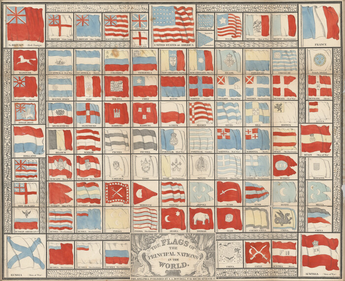
The Flags of the Principal Nations in the World
Print $20.00
- Digital $50.00
The Flags of the Principal Nations in the World
1845
Size 18.3 x 22.6 inches
Map/Doc 97533
Pecos County Rolled Sketch 129

Print $40.00
- Digital $50.00
Pecos County Rolled Sketch 129
1948
Size 42.9 x 52.4 inches
Map/Doc 9727