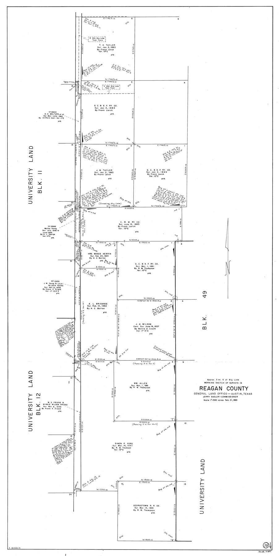
Reagan County Working Sketch 38
-
Map/Doc
71880
-
Collection
General Map Collection
-
Object Dates
2/21/1969 (Creation Date)
-
People and Organizations
Roy Buckholts (Draftsman)
-
Counties
Reagan
-
Subjects
Surveying Working Sketch
-
Height x Width
60.8 x 30.5 inches
154.4 x 77.5 cm
-
Scale
1" = 300 varas
Part of: General Map Collection
Fort Bend County Working Sketch 12

Print $40.00
- Digital $50.00
Fort Bend County Working Sketch 12
1940
Size 29.9 x 73.2 inches
Map/Doc 69219
Winkler County Sketch File 1 and 2

Print $64.00
- Digital $50.00
Winkler County Sketch File 1 and 2
1900
Size 8.4 x 9.2 inches
Map/Doc 40431
Hays County Sketch File 9

Print $6.00
- Digital $50.00
Hays County Sketch File 9
Size 9.6 x 16.2 inches
Map/Doc 26212
Map of McCulloch County

Print $20.00
- Digital $50.00
Map of McCulloch County
1874
Size 26.7 x 20.7 inches
Map/Doc 3857
Aransas County Rolled Sketch 3

Print $20.00
- Digital $50.00
Aransas County Rolled Sketch 3
Size 20.9 x 26.5 inches
Map/Doc 77188
Goliad County Rolled Sketch 5

Print $20.00
- Digital $50.00
Goliad County Rolled Sketch 5
1956
Size 26.5 x 29.5 inches
Map/Doc 6025
DeWitt County Sketch File 11

Print $20.00
- Digital $50.00
DeWitt County Sketch File 11
1851
Size 24.5 x 35.2 inches
Map/Doc 11314
Kleberg County Rolled Sketch 10-43

Print $20.00
- Digital $50.00
Kleberg County Rolled Sketch 10-43
1951
Size 37.2 x 34.9 inches
Map/Doc 9395
San Jacinto County Working Sketch 31

Print $20.00
- Digital $50.00
San Jacinto County Working Sketch 31
1953
Size 29.1 x 30.4 inches
Map/Doc 63744
Map of Presidio County

Print $40.00
- Digital $50.00
Map of Presidio County
1895
Size 53.0 x 38.6 inches
Map/Doc 3968
Coke County Rolled Sketch 3

Print $20.00
- Digital $50.00
Coke County Rolled Sketch 3
1947
Size 40.6 x 40.3 inches
Map/Doc 8623
Hemphill County Working Sketch 33

Print $20.00
- Digital $50.00
Hemphill County Working Sketch 33
1976
Size 39.6 x 32.3 inches
Map/Doc 66128
You may also like
Kenedy County Rolled Sketch 15

Print $15.00
- Digital $50.00
Kenedy County Rolled Sketch 15
1942
Size 10.2 x 15.2 inches
Map/Doc 46426
East Part of Anderson County

Print $40.00
- Digital $50.00
East Part of Anderson County
1942
Size 52.0 x 42.3 inches
Map/Doc 77198
Lavaca County Working Sketch 14

Print $20.00
- Digital $50.00
Lavaca County Working Sketch 14
1962
Size 28.4 x 29.7 inches
Map/Doc 70367
Houston County Rolled Sketch 8

Print $20.00
- Digital $50.00
Houston County Rolled Sketch 8
1948
Size 27.7 x 20.3 inches
Map/Doc 6228
Nueces County

Print $20.00
- Digital $50.00
Nueces County
1913
Size 26.4 x 34.1 inches
Map/Doc 66957
Montgomery County Working Sketch 16

Print $20.00
- Digital $50.00
Montgomery County Working Sketch 16
1934
Size 28.9 x 33.7 inches
Map/Doc 71123
Green & Lumsden's Ranch

Print $20.00
- Digital $50.00
Green & Lumsden's Ranch
Size 28.4 x 24.7 inches
Map/Doc 92431
Blanco County Rolled Sketch 5

Print $20.00
- Digital $50.00
Blanco County Rolled Sketch 5
Size 15.6 x 17.0 inches
Map/Doc 5143
Briscoe County Working Sketch 9

Print $20.00
- Digital $50.00
Briscoe County Working Sketch 9
1951
Size 24.9 x 36.7 inches
Map/Doc 67812

Houston County Working Sketch 26

Print $20.00
- Digital $50.00
Houston County Working Sketch 26
1987
Size 30.1 x 20.4 inches
Map/Doc 66256
Sterling County Sketch File 15

Print $8.00
- Digital $50.00
Sterling County Sketch File 15
1935
Size 11.1 x 8.8 inches
Map/Doc 37150