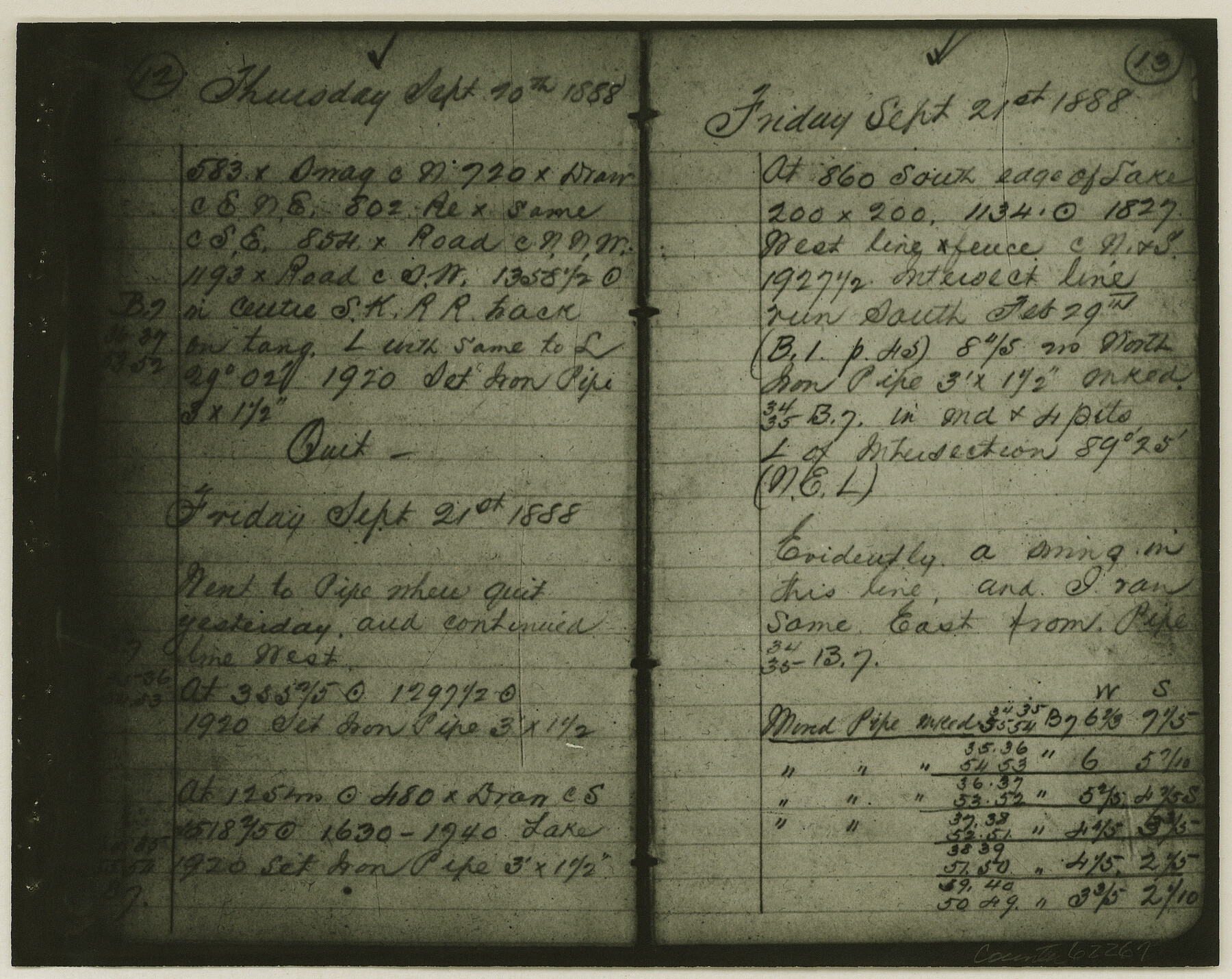
Copy of Surveyor's Field Book, Morris Browning - In Blocks 7, 5 & 4, I&GNRRCo., Hutchinson and Carson Counties, Texas
K-7-70
-
Map/Doc
62267
-
Collection
General Map Collection
-
Object Dates
1888/10/22 (Creation Date)
-
People and Organizations
Morris Browning (Surveyor/Engineer)
-
Counties
Hutchinson Carson
-
Height x Width
7.0 x 8.8 inches
17.8 x 22.4 cm
-
Comments
Copy of Surveyor's field book presented to the General Land Office by Morris Browning on February 3, 1941.
Surveyed from September 14, 1888 to October 22, 1888.
Part of: General Map Collection
Austin County Working Sketch 6

Print $20.00
- Digital $50.00
Austin County Working Sketch 6
1985
Size 30.3 x 28.5 inches
Map/Doc 67247
Presidio County Working Sketch 121a

Print $20.00
- Digital $50.00
Presidio County Working Sketch 121a
Size 34.2 x 38.0 inches
Map/Doc 71798
Limestone County Sketch File 24

Print $8.00
- Digital $50.00
Limestone County Sketch File 24
1942
Size 11.2 x 8.8 inches
Map/Doc 30206
[Sketch for Mineral Application 1112 - Colorado River, H. E. Chambers]
![65638, [Sketch for Mineral Application 1112 - Colorado River, H. E. Chambers], General Map Collection](https://historictexasmaps.com/wmedia_w700/maps/65638.tif.jpg)
Print $20.00
- Digital $50.00
[Sketch for Mineral Application 1112 - Colorado River, H. E. Chambers]
1918
Size 17.5 x 28.2 inches
Map/Doc 65638
Sutton County Sketch File 57

Print $24.00
- Digital $50.00
Sutton County Sketch File 57
1961
Size 11.2 x 8.8 inches
Map/Doc 37542
Dimmit County Rolled Sketch 2

Print $20.00
- Digital $50.00
Dimmit County Rolled Sketch 2
Size 33.9 x 39.6 inches
Map/Doc 8793
Reagan County Working Sketch 12

Print $20.00
- Digital $50.00
Reagan County Working Sketch 12
1948
Size 24.1 x 44.9 inches
Map/Doc 71852
Harris County Working Sketch 42

Print $20.00
- Digital $50.00
Harris County Working Sketch 42
1940
Size 31.8 x 38.5 inches
Map/Doc 65934
Collin County Sketch File 13

Print $4.00
- Digital $50.00
Collin County Sketch File 13
1874
Size 8.8 x 6.8 inches
Map/Doc 18872
Flight Mission No. CUG-3P, Frame 159, Kleberg County

Print $20.00
- Digital $50.00
Flight Mission No. CUG-3P, Frame 159, Kleberg County
1956
Size 18.7 x 22.3 inches
Map/Doc 86279
Chambers County Sketch File 56

Print $7.00
- Digital $50.00
Chambers County Sketch File 56
Size 14.8 x 8.7 inches
Map/Doc 18099
Uvalde County Sketch File 28

Print $10.00
- Digital $50.00
Uvalde County Sketch File 28
1980
Size 14.8 x 8.9 inches
Map/Doc 39023
You may also like
Dickens County Sketch File 36

Print $4.00
- Digital $50.00
Dickens County Sketch File 36
1891
Size 11.3 x 9.1 inches
Map/Doc 21042
Sutton County Working Sketch 39

Print $20.00
- Digital $50.00
Sutton County Working Sketch 39
1945
Size 29.6 x 25.8 inches
Map/Doc 62382
Upton County Working Sketch Graphic Index, Sheet 1 (Sketches 1 to 39)

Print $40.00
- Digital $50.00
Upton County Working Sketch Graphic Index, Sheet 1 (Sketches 1 to 39)
1969
Size 49.9 x 37.0 inches
Map/Doc 76721
Flight Mission No. DQN-2K, Frame 79, Calhoun County

Print $20.00
- Digital $50.00
Flight Mission No. DQN-2K, Frame 79, Calhoun County
1953
Size 16.0 x 16.0 inches
Map/Doc 84271
Young County Rolled Sketch 10

Print $20.00
- Digital $50.00
Young County Rolled Sketch 10
1921
Size 27.3 x 40.1 inches
Map/Doc 8298
Ochiltree County Working Sketch 7

Print $40.00
- Digital $50.00
Ochiltree County Working Sketch 7
1968
Size 26.8 x 56.6 inches
Map/Doc 71320
Limestone County Sketch File 19

Print $4.00
- Digital $50.00
Limestone County Sketch File 19
1922
Size 11.0 x 8.7 inches
Map/Doc 30193
Packery Channel

Print $20.00
- Digital $50.00
Packery Channel
1950
Size 17.2 x 17.1 inches
Map/Doc 2996
Sutton County Sketch File 37

Print $20.00
- Digital $50.00
Sutton County Sketch File 37
Size 19.7 x 19.7 inches
Map/Doc 12387
Garza County Rolled Sketch 3

Print $20.00
- Digital $50.00
Garza County Rolled Sketch 3
1900
Size 32.7 x 47.7 inches
Map/Doc 75937
Haskell County Sketch File 24

Print $20.00
- Digital $50.00
Haskell County Sketch File 24
Size 17.8 x 28.5 inches
Map/Doc 11747
Cherokee County Working Sketch 2

Print $20.00
- Digital $50.00
Cherokee County Working Sketch 2
1932
Size 40.8 x 35.9 inches
Map/Doc 67957