Dickens County Sketch File 36
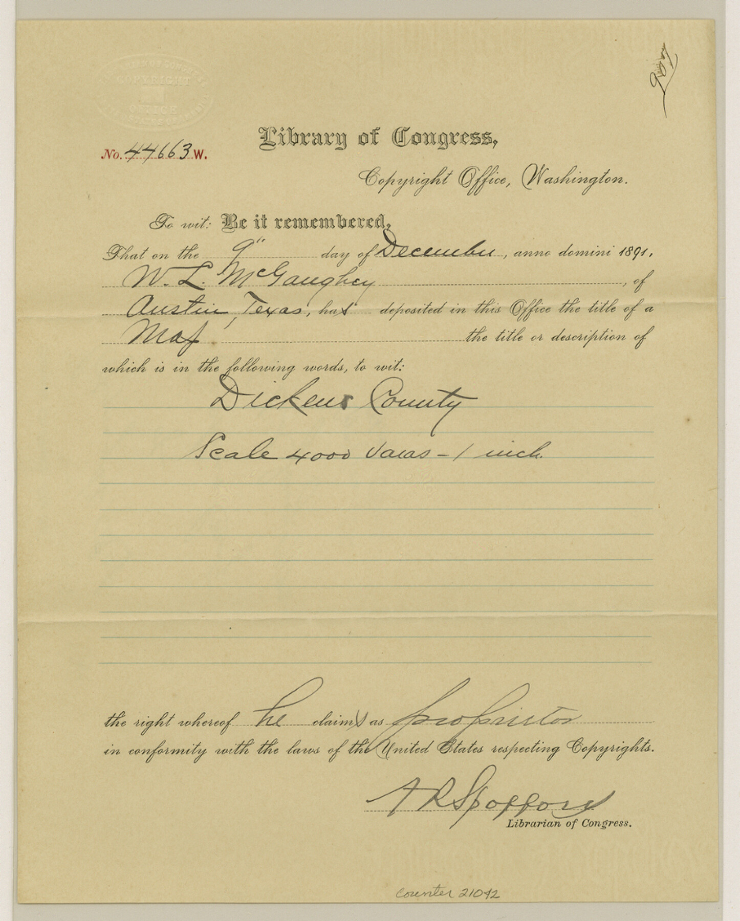
[Copyright certificate from Library of Congress for Dickens County map]
-
Map/Doc
21042
-
Collection
General Map Collection
-
Object Dates
1891/12/9 (Creation Date)
1892/1/19 (File Date)
-
People and Organizations
George M. Williams (Surveyor/Engineer)
E. von Rosenberg (Draftsman)
-
Counties
Dickens
-
Subjects
Surveying Sketch File
-
Height x Width
11.3 x 9.1 inches
28.7 x 23.1 cm
-
Medium
paper, manuscript
Part of: General Map Collection
Presidio County Sketch File 48

Print $6.00
- Digital $50.00
Presidio County Sketch File 48
1918
Size 15.1 x 11.0 inches
Map/Doc 34582
Shelby County Sketch File 27

Print $4.00
- Digital $50.00
Shelby County Sketch File 27
Size 6.5 x 8.0 inches
Map/Doc 36662
Menard County Sketch File 22

Print $8.00
- Digital $50.00
Menard County Sketch File 22
1927
Size 7.4 x 8.6 inches
Map/Doc 31553
Bandera County Rolled Sketch 13

Print $20.00
- Digital $50.00
Bandera County Rolled Sketch 13
2018
Size 24.1 x 20.5 inches
Map/Doc 95305
Hutchinson County Sketch File 47

Print $28.00
- Digital $50.00
Hutchinson County Sketch File 47
1958
Size 8.3 x 10.1 inches
Map/Doc 27390
Polk County Working Sketch 13

Print $20.00
- Digital $50.00
Polk County Working Sketch 13
1942
Size 17.1 x 20.6 inches
Map/Doc 71628
Falls of St. Anthony

Print $2.00
- Digital $50.00
Falls of St. Anthony
1810
Size 6.2 x 8.8 inches
Map/Doc 95152
Flight Mission No. DQO-1K, Frame 89, Galveston County

Print $20.00
- Digital $50.00
Flight Mission No. DQO-1K, Frame 89, Galveston County
1952
Size 18.9 x 22.5 inches
Map/Doc 84985
Montgomery County Rolled Sketch 38

Print $40.00
- Digital $50.00
Montgomery County Rolled Sketch 38
1962
Size 56.0 x 30.8 inches
Map/Doc 9545
Stonewall County Rolled Sketch 31

Print $20.00
- Digital $50.00
Stonewall County Rolled Sketch 31
1982
Size 25.6 x 42.9 inches
Map/Doc 7875
Nueces County Rolled Sketch 126 A-G

Print $22.00
- Digital $50.00
Nueces County Rolled Sketch 126 A-G
1998
Size 11.3 x 8.8 inches
Map/Doc 8962
Burnet County Working Sketch 9

Print $20.00
- Digital $50.00
Burnet County Working Sketch 9
1975
Size 39.7 x 25.2 inches
Map/Doc 67852
You may also like
General Highway Map, Walker County, Texas

Print $20.00
General Highway Map, Walker County, Texas
1940
Size 24.9 x 18.4 inches
Map/Doc 79269
Flight Mission No. DQO-2K, Frame 139, Galveston County

Print $20.00
- Digital $50.00
Flight Mission No. DQO-2K, Frame 139, Galveston County
1952
Size 18.8 x 22.5 inches
Map/Doc 85036
Flight Mission No. CUG-1P, Frame 106, Kleberg County

Print $20.00
- Digital $50.00
Flight Mission No. CUG-1P, Frame 106, Kleberg County
1956
Size 18.8 x 22.3 inches
Map/Doc 86156
Controlled Mosaic by Jack Amman Photogrammetric Engineers, Inc - Sheet 53

Print $20.00
- Digital $50.00
Controlled Mosaic by Jack Amman Photogrammetric Engineers, Inc - Sheet 53
1954
Size 20.0 x 24.0 inches
Map/Doc 83512
Brewster County Working Sketch 74

Print $20.00
- Digital $50.00
Brewster County Working Sketch 74
1966
Size 24.8 x 32.0 inches
Map/Doc 67674
Newton County Working Sketch 6

Print $20.00
- Digital $50.00
Newton County Working Sketch 6
1930
Size 35.5 x 25.9 inches
Map/Doc 71252
[Map of the City of Austin]
![4802, [Map of the City of Austin], General Map Collection](https://historictexasmaps.com/wmedia_w700/maps/4802-1.tif.jpg)
Print $20.00
- Digital $50.00
[Map of the City of Austin]
1856
Size 29.1 x 21.5 inches
Map/Doc 4802
Layout of the porciones as described in the Visita General of Reynosa, 1767

Layout of the porciones as described in the Visita General of Reynosa, 1767
2009
Size 11.0 x 8.5 inches
Map/Doc 94045
Kinney County Working Sketch 59

Print $20.00
- Digital $50.00
Kinney County Working Sketch 59
1999
Size 19.9 x 24.8 inches
Map/Doc 70241
Presidio County Working Sketch 49

Print $20.00
- Digital $50.00
Presidio County Working Sketch 49
1951
Size 34.5 x 47.0 inches
Map/Doc 71726
Terrell County Working Sketch 60

Print $40.00
- Digital $50.00
Terrell County Working Sketch 60
1962
Size 20.2 x 67.0 inches
Map/Doc 69581
Coleman County Sketch File 23

Print $6.00
- Digital $50.00
Coleman County Sketch File 23
1872
Size 10.1 x 15.7 inches
Map/Doc 18703