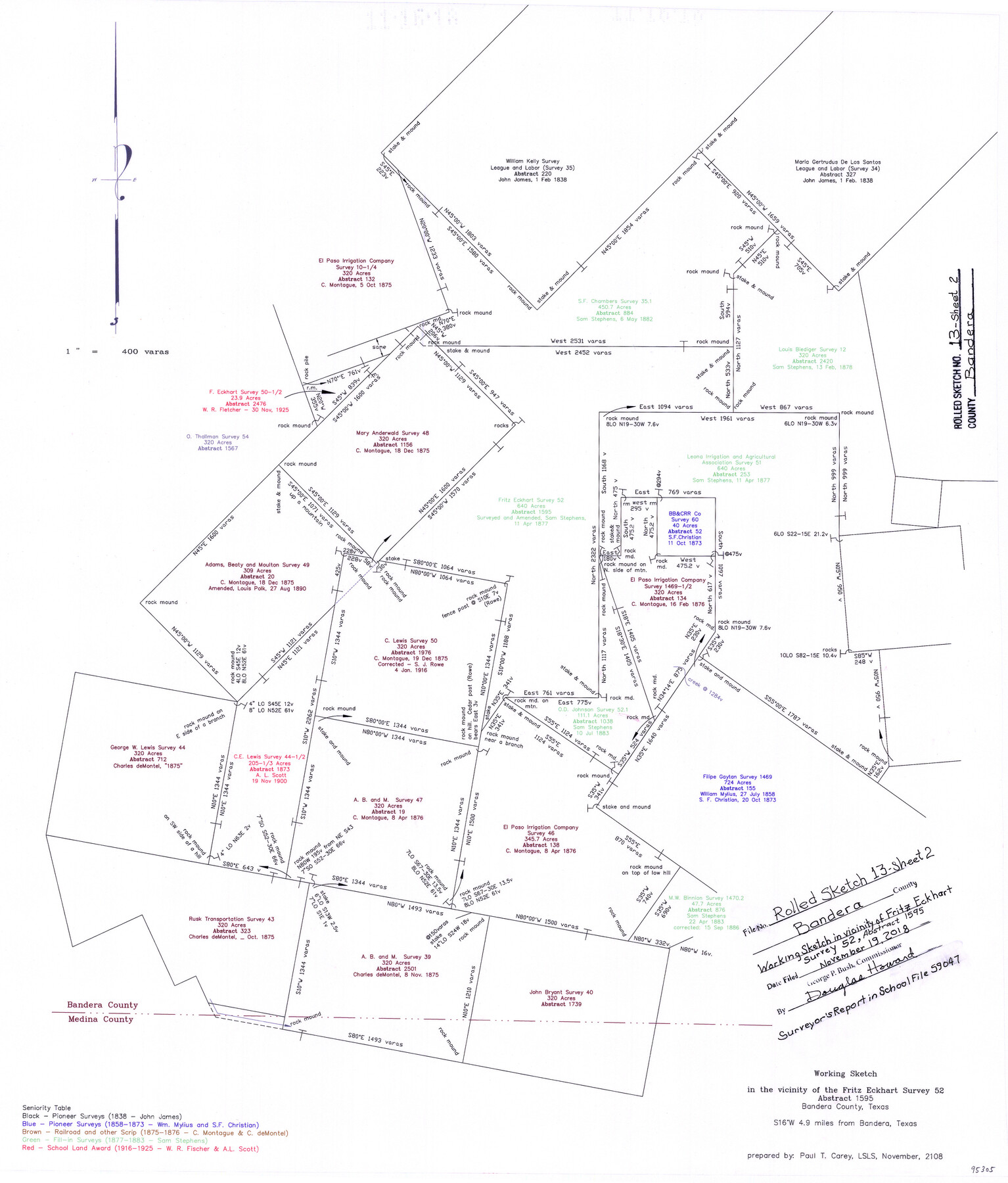
Bandera County Rolled Sketch 13
Working sketch in the vicinity of the Fritz Eckhart survey 52, abstract 1595
-
Map/Doc
95305
-
Collection
General Map Collection
-
Object Dates
5/16/2018 (Creation Date)
11/19/2018 (File Date)
-
People and Organizations
Paul T. Carey (Surveyor/Engineer)
-
Counties
Bandera
-
Subjects
Surveying Rolled Sketch
-
Height x Width
24.1 x 20.5 inches
61.2 x 52.1 cm
-
Medium
mylar, print
-
Scale
1" = 400 varas
-
Comments
Sheet 2 of 2. For first sheet see map 95304 See surveyor's report in School File 59047.
Related maps
Bandera County Rolled Sketch 13

Print $20.00
- Digital $50.00
Bandera County Rolled Sketch 13
2018
Size 25.0 x 20.7 inches
Map/Doc 95304
Part of: General Map Collection
Menard County Working Sketch 4

Print $20.00
- Digital $50.00
Menard County Working Sketch 4
1914
Size 19.8 x 16.2 inches
Map/Doc 70951
Crockett County Working Sketch 95

Print $20.00
- Digital $50.00
Crockett County Working Sketch 95
1979
Size 26.6 x 47.2 inches
Map/Doc 68428
Limestone County Working Sketch 17

Print $20.00
- Digital $50.00
Limestone County Working Sketch 17
1959
Size 42.2 x 33.1 inches
Map/Doc 70567
Henderson County Working Sketch 12

Print $20.00
- Digital $50.00
Henderson County Working Sketch 12
1915
Size 23.3 x 24.9 inches
Map/Doc 66145
Val Verde County Sketch File Z5

Print $20.00
- Digital $50.00
Val Verde County Sketch File Z5
Size 32.3 x 26.1 inches
Map/Doc 12551
El Paso County Rolled Sketch LH

Print $20.00
- Digital $50.00
El Paso County Rolled Sketch LH
1890
Size 20.3 x 31.7 inches
Map/Doc 5858
Brewster County Working Sketch 58

Print $20.00
- Digital $50.00
Brewster County Working Sketch 58
1955
Size 19.8 x 21.7 inches
Map/Doc 67659
Polk County Working Sketch 36

Print $20.00
- Digital $50.00
Polk County Working Sketch 36
1963
Size 28.4 x 38.1 inches
Map/Doc 71653
San Saba County Rolled Sketch 3

Print $20.00
- Digital $50.00
San Saba County Rolled Sketch 3
Size 31.9 x 43.3 inches
Map/Doc 7744
Martin County Sketch File 5

Print $4.00
- Digital $50.00
Martin County Sketch File 5
1913
Size 11.4 x 8.7 inches
Map/Doc 30640
Texas, Corpus Christi, Corpus Christi to Laguna Madre

Print $40.00
- Digital $50.00
Texas, Corpus Christi, Corpus Christi to Laguna Madre
1934
Size 35.1 x 48.6 inches
Map/Doc 73457
Dallam County Rolled Sketch EB

Print $66.00
- Digital $50.00
Dallam County Rolled Sketch EB
1902
Size 41.2 x 31.3 inches
Map/Doc 9410
You may also like
Titus County Boundary File 2

Print $6.00
- Digital $50.00
Titus County Boundary File 2
Size 7.7 x 6.7 inches
Map/Doc 59297
El Paso County Rolled Sketch 57A

Print $40.00
- Digital $50.00
El Paso County Rolled Sketch 57A
1984
Size 49.2 x 39.4 inches
Map/Doc 8879
Val Verde County Working Sketch 61

Print $20.00
- Digital $50.00
Val Verde County Working Sketch 61
1958
Size 25.1 x 32.9 inches
Map/Doc 72196
Liberty County Rolled Sketch E

Print $20.00
- Digital $50.00
Liberty County Rolled Sketch E
Size 20.8 x 31.0 inches
Map/Doc 9439
Nueces County Sketch File 22

Print $20.00
- Digital $50.00
Nueces County Sketch File 22
Size 19.0 x 31.0 inches
Map/Doc 42181
Map of Fort Bend County, Texas

Print $20.00
- Digital $50.00
Map of Fort Bend County, Texas
1882
Size 23.0 x 25.7 inches
Map/Doc 434
Llano County Sketch File 20

Print $4.00
- Digital $50.00
Llano County Sketch File 20
1873
Size 12.6 x 8.2 inches
Map/Doc 30405
El Paso County Working Sketch 40

Print $20.00
- Digital $50.00
El Paso County Working Sketch 40
1992
Size 21.5 x 24.0 inches
Map/Doc 69062
[Blocks M-22 and M-25 and vicinity]
![91138, [Blocks M-22 and M-25 and vicinity], Twichell Survey Records](https://historictexasmaps.com/wmedia_w700/maps/91138-1.tif.jpg)
Print $20.00
- Digital $50.00
[Blocks M-22 and M-25 and vicinity]
Size 18.7 x 16.6 inches
Map/Doc 91138
Waller County Working Sketch 1

Print $20.00
- Digital $50.00
Waller County Working Sketch 1
1899
Size 16.2 x 21.2 inches
Map/Doc 72300
Brazoria County Working Sketch 24

Print $20.00
- Digital $50.00
Brazoria County Working Sketch 24
1963
Size 35.7 x 25.0 inches
Map/Doc 67509
Wharton County Working Sketch 10

Print $20.00
- Digital $50.00
Wharton County Working Sketch 10
1980
Size 23.6 x 18.7 inches
Map/Doc 72474