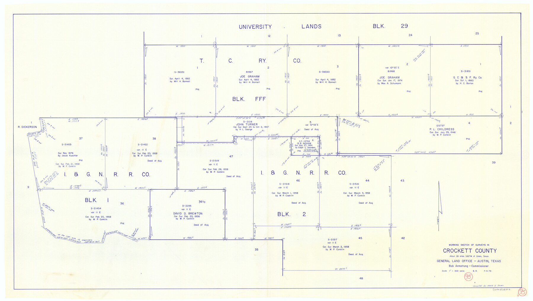
Crockett County Working Sketch 95
-
Map/Doc
68428
-
Collection
General Map Collection
-
Object Dates
7/5/1979 (Creation Date)
-
People and Organizations
Beverly Robison (Draftsman)
-
Counties
Crockett
-
Subjects
Surveying Working Sketch
-
Height x Width
26.6 x 47.2 inches
67.6 x 119.9 cm
-
Scale
1" = 300 varas
Part of: General Map Collection
Map of Wharton County

Print $20.00
- Digital $50.00
Map of Wharton County
1871
Size 22.3 x 23.6 inches
Map/Doc 4135
Terrell County Working Sketch 2

Print $20.00
- Digital $50.00
Terrell County Working Sketch 2
1908
Size 19.8 x 24.2 inches
Map/Doc 62150
San Saba County Sketch File 13A

Print $20.00
- Digital $50.00
San Saba County Sketch File 13A
1891
Size 25.2 x 17.6 inches
Map/Doc 12292
Flight Mission No. BQY-4M, Frame 36, Harris County

Print $20.00
- Digital $50.00
Flight Mission No. BQY-4M, Frame 36, Harris County
1953
Size 18.6 x 22.3 inches
Map/Doc 85251
Jefferson County Rolled Sketch 44

Print $20.00
- Digital $50.00
Jefferson County Rolled Sketch 44
1957
Size 26.9 x 25.5 inches
Map/Doc 6401
Flight Mission No. DIX-10P, Frame 148, Aransas County

Print $20.00
- Digital $50.00
Flight Mission No. DIX-10P, Frame 148, Aransas County
1956
Size 18.6 x 22.3 inches
Map/Doc 83950
Aransas County Rolled Sketch 5

Print $53.00
- Digital $50.00
Aransas County Rolled Sketch 5
1953
Size 10.5 x 15.4 inches
Map/Doc 42075
Webb County Working Sketch 85

Print $20.00
- Digital $50.00
Webb County Working Sketch 85
1981
Size 21.1 x 29.0 inches
Map/Doc 72452
Motley County Sketch File 3 (S)

Print $6.00
- Digital $50.00
Motley County Sketch File 3 (S)
Size 9.5 x 13.0 inches
Map/Doc 32141
D No. 5 - Reconnaissance of Hatteras Inlet, North Carolina

Print $20.00
- Digital $50.00
D No. 5 - Reconnaissance of Hatteras Inlet, North Carolina
1853
Size 17.1 x 14.9 inches
Map/Doc 97212
Presidio County Rolled Sketch 135

Print $20.00
- Digital $50.00
Presidio County Rolled Sketch 135
1996
Size 38.4 x 26.8 inches
Map/Doc 7402
Burnet County Working Sketch 20

Print $40.00
- Digital $50.00
Burnet County Working Sketch 20
1983
Size 48.1 x 41.2 inches
Map/Doc 67863
You may also like
El Paso County Rolled Sketch 64

Print $246.00
- Digital $50.00
El Paso County Rolled Sketch 64
1993
Size 11.3 x 8.7 inches
Map/Doc 41531
Travis County Appraisal District Plat Map 2_0404

Print $20.00
- Digital $50.00
Travis County Appraisal District Plat Map 2_0404
Size 21.5 x 26.4 inches
Map/Doc 94229
Howard County Rolled Sketch 8

Print $20.00
- Digital $50.00
Howard County Rolled Sketch 8
Size 16.8 x 40.2 inches
Map/Doc 6237
Flight Mission No. CLL-1N, Frame 8, Willacy County

Print $20.00
- Digital $50.00
Flight Mission No. CLL-1N, Frame 8, Willacy County
1954
Size 18.3 x 22.1 inches
Map/Doc 86995
Presidio County Boundary File 3a

Print $40.00
- Digital $50.00
Presidio County Boundary File 3a
Size 17.7 x 38.0 inches
Map/Doc 58074
Visitor's Guide to Mexico City, D.F. [and Index to Cities and Villages and Route Summaries]
![96822, Visitor's Guide to Mexico City, D.F. [and Index to Cities and Villages and Route Summaries], General Map Collection](https://historictexasmaps.com/wmedia_w700/maps/96822.tif.jpg)
Visitor's Guide to Mexico City, D.F. [and Index to Cities and Villages and Route Summaries]
1999
Size 33.7 x 25.1 inches
Map/Doc 96822
Current Miscellaneous File 87

Print $8.00
- Digital $50.00
Current Miscellaneous File 87
Size 11.3 x 8.6 inches
Map/Doc 74243


Flight Mission No. DQN-3K, Frame 10, Calhoun County

Print $20.00
- Digital $50.00
Flight Mission No. DQN-3K, Frame 10, Calhoun County
1953
Size 18.5 x 22.2 inches
Map/Doc 84342
Kendall County Sketch File 5

Print $4.00
- Digital $50.00
Kendall County Sketch File 5
1854
Size 8.7 x 7.6 inches
Map/Doc 28686
Wichita County Sketch File 26

Print $20.00
- Digital $50.00
Wichita County Sketch File 26
1919
Size 24.9 x 36.6 inches
Map/Doc 12686