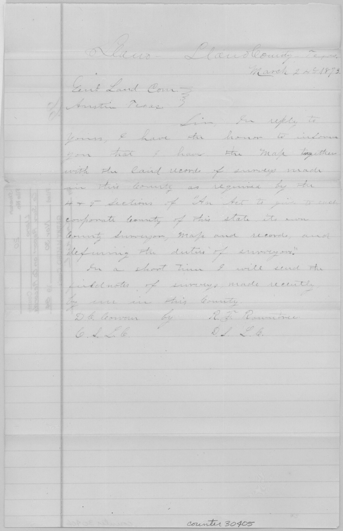
Llano County Sketch File 20
[County Surveyor's report on county records]
-
Map/Doc
30405
-
Collection
General Map Collection
-
Object Dates
3/24/1873 (Creation Date)
11/30/1984 (File Date)
-
People and Organizations
R.F. Rountree (Surveyor/Engineer)
-
Counties
Llano
-
Subjects
Surveying Sketch File
-
Height x Width
12.6 x 8.2 inches
32.0 x 20.8 cm
-
Medium
paper, manuscript
Part of: General Map Collection
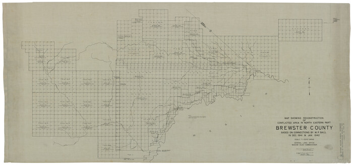
Brewster County Rolled Sketch 121
Print $40.00
- Digital $50.00
Brewster County Rolled Sketch 121
1942
Size 43.3 x 92.8 inches
Map/Doc 93790
Flight Mission No. DAG-24K, Frame 50, Matagorda County

Print $20.00
- Digital $50.00
Flight Mission No. DAG-24K, Frame 50, Matagorda County
1953
Size 16.0 x 16.0 inches
Map/Doc 86537
Haskell County Working Sketch 8

Print $20.00
- Digital $50.00
Haskell County Working Sketch 8
1957
Size 22.8 x 24.0 inches
Map/Doc 66066
Llano County Working Sketch 9

Print $20.00
- Digital $50.00
Llano County Working Sketch 9
1979
Size 33.4 x 24.0 inches
Map/Doc 70627
Concho County Rolled Sketch 26

Print $20.00
- Digital $50.00
Concho County Rolled Sketch 26
1979
Size 15.1 x 18.1 inches
Map/Doc 5558
Cass County Working Sketch 54

Print $20.00
- Digital $50.00
Cass County Working Sketch 54
2012
Size 26.2 x 21.6 inches
Map/Doc 93337
Waller County Working Sketch 4

Print $20.00
- Digital $50.00
Waller County Working Sketch 4
1965
Size 17.3 x 18.8 inches
Map/Doc 72303
Bastrop County Working Sketch 7

Print $20.00
- Digital $50.00
Bastrop County Working Sketch 7
1930
Size 32.7 x 29.7 inches
Map/Doc 67307
Cameron County Rolled Sketch 20E

Print $20.00
- Digital $50.00
Cameron County Rolled Sketch 20E
Size 12.9 x 11.4 inches
Map/Doc 5479
Liberty County

Print $20.00
- Digital $50.00
Liberty County
1862
Size 24.3 x 24.8 inches
Map/Doc 3815
Polk County Sketch File 20

Print $4.00
- Digital $50.00
Polk County Sketch File 20
Size 6.1 x 8.2 inches
Map/Doc 34167
Galveston County Rolled Sketch 41

Print $20.00
- Digital $50.00
Galveston County Rolled Sketch 41
1988
Size 23.1 x 37.0 inches
Map/Doc 5972
You may also like
Kaufman County Sketch File 11

Print $4.00
- Digital $50.00
Kaufman County Sketch File 11
1874
Size 10.2 x 8.4 inches
Map/Doc 28645
Atascosa County Working Sketch 3

Print $20.00
- Digital $50.00
Atascosa County Working Sketch 3
1912
Size 26.3 x 13.2 inches
Map/Doc 67198
Lgs. 276 thru 280-289, 333, 336, 345, 355 thru 357, 367, Blk. K11

Print $20.00
- Digital $50.00
Lgs. 276 thru 280-289, 333, 336, 345, 355 thru 357, 367, Blk. K11
Size 28.0 x 12.3 inches
Map/Doc 91429
Webb County Sketch File 68

Print $26.00
- Digital $50.00
Webb County Sketch File 68
1952
Size 19.9 x 25.0 inches
Map/Doc 12656
The Republic County of Victoria. January 29, 1842

Print $20.00
The Republic County of Victoria. January 29, 1842
2020
Size 24.3 x 21.7 inches
Map/Doc 96298
Dallas County

Print $20.00
- Digital $50.00
Dallas County
1942
Size 45.5 x 38.0 inches
Map/Doc 16954
Map of Webb County

Print $20.00
- Digital $50.00
Map of Webb County
1879
Size 36.8 x 25.4 inches
Map/Doc 4131
Floyd County Sketch File 1

Print $5.00
- Digital $50.00
Floyd County Sketch File 1
Size 11.0 x 17.0 inches
Map/Doc 22688
The Chief Justice County of Mina. Lands in Conflict with Colorado County

Print $20.00
The Chief Justice County of Mina. Lands in Conflict with Colorado County
2020
Size 15.8 x 21.7 inches
Map/Doc 96062
Galveston County Sketch File 16

Print $6.00
- Digital $50.00
Galveston County Sketch File 16
Size 7.8 x 6.3 inches
Map/Doc 23384
Lay's Eagle of the United States

Price $20.00
Lay's Eagle of the United States
2020
Size 3.6 x 4.9 inches
Map/Doc 95952
Travis County State Real Property Sketch 6

Print $40.00
- Digital $50.00
Travis County State Real Property Sketch 6
1987
Size 30.2 x 41.4 inches
Map/Doc 61697