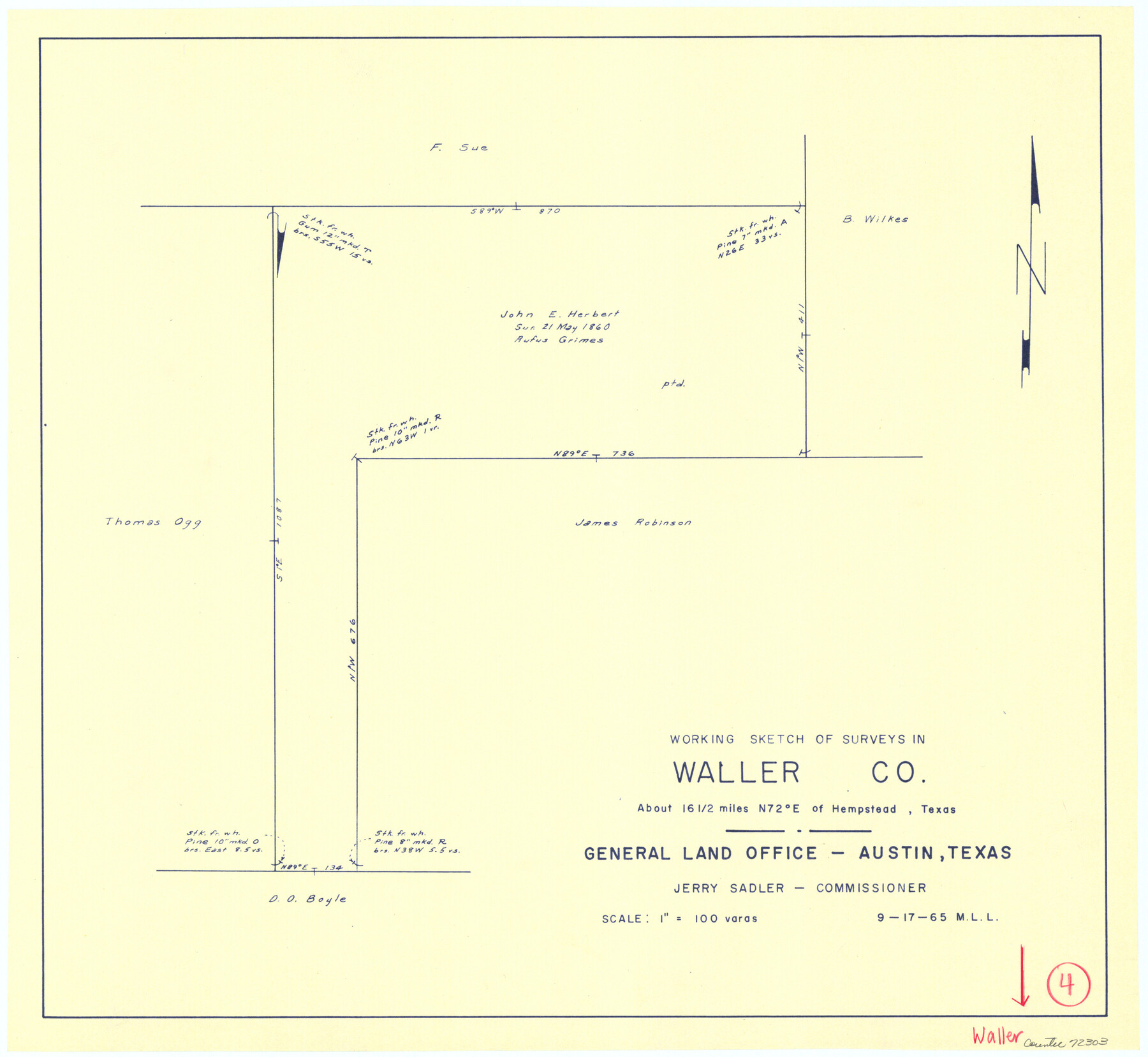
Waller County Working Sketch 4
-
Map/Doc
72303
-
Collection
General Map Collection
-
Object Dates
9/17/1965 (Creation Date)
-
People and Organizations
M. L. Liles (Draftsman)
-
Counties
Waller
-
Subjects
Surveying Working Sketch
-
Height x Width
17.3 x 18.8 inches
43.9 x 47.8 cm
-
Scale
1" = 100 varas
Part of: General Map Collection
Guadalupe County Working Sketch 12

Print $20.00
- Digital $50.00
Guadalupe County Working Sketch 12
2005
Size 29.1 x 23.5 inches
Map/Doc 83571
Crockett County Rolled Sketch 70

Print $20.00
- Digital $50.00
Crockett County Rolled Sketch 70
1949
Size 15.1 x 17.0 inches
Map/Doc 5612
Henderson County Sketch File 10

Print $4.00
- Digital $50.00
Henderson County Sketch File 10
1859
Size 12.8 x 8.3 inches
Map/Doc 26346
Blanco County Rolled Sketch 13

Print $20.00
- Digital $50.00
Blanco County Rolled Sketch 13
Size 14.2 x 28.9 inches
Map/Doc 5149

Old Miscellaneous File 8

Print $15.00
- Digital $50.00
Old Miscellaneous File 8
1853
Size 16.7 x 10.5 inches
Map/Doc 75427

Liberty County Rolled Sketch N

Print $20.00
- Digital $50.00
Liberty County Rolled Sketch N
Size 44.7 x 38.5 inches
Map/Doc 10180
Hudspeth County Sketch File 21

Print $40.00
- Digital $50.00
Hudspeth County Sketch File 21
Size 60.1 x 38.0 inches
Map/Doc 10495
Wise County Working Sketch 16

Print $20.00
- Digital $50.00
Wise County Working Sketch 16
1960
Size 28.0 x 39.0 inches
Map/Doc 72630
Sabine Pass and Lake

Print $40.00
- Digital $50.00
Sabine Pass and Lake
1992
Size 49.2 x 28.6 inches
Map/Doc 69828
Brewster County Rolled Sketch 101

Print $40.00
- Digital $50.00
Brewster County Rolled Sketch 101
1927
Size 63.0 x 46.2 inches
Map/Doc 10648
You may also like
Dimmit County Sketch File 20a

Print $2.00
- Digital $50.00
Dimmit County Sketch File 20a
Size 9.3 x 4.3 inches
Map/Doc 21103
San Jacinto County Working Sketch 6

Print $20.00
- Digital $50.00
San Jacinto County Working Sketch 6
1934
Size 37.1 x 42.5 inches
Map/Doc 63719
North Sulphur River, Ben Franklin Sheet

Print $40.00
- Digital $50.00
North Sulphur River, Ben Franklin Sheet
1928
Size 24.6 x 57.4 inches
Map/Doc 65172
Somervell County Sketch File 7

Print $8.00
- Digital $50.00
Somervell County Sketch File 7
1987
Size 11.4 x 8.9 inches
Map/Doc 36850
Lavaca County Working Sketch 14

Print $20.00
- Digital $50.00
Lavaca County Working Sketch 14
1962
Size 28.4 x 29.7 inches
Map/Doc 70367
Leon County Working Sketch 37

Print $20.00
- Digital $50.00
Leon County Working Sketch 37
1979
Size 43.2 x 37.7 inches
Map/Doc 70436
The Republic County of Robertson. Spring 1842

Print $20.00
The Republic County of Robertson. Spring 1842
2020
Size 16.9 x 21.7 inches
Map/Doc 96263
Flight Mission No. BQR-5K, Frame 62, Brazoria County

Print $20.00
- Digital $50.00
Flight Mission No. BQR-5K, Frame 62, Brazoria County
1952
Size 18.9 x 22.6 inches
Map/Doc 84007
Presidio County Working Sketch 40

Print $20.00
- Digital $50.00
Presidio County Working Sketch 40
1948
Size 33.2 x 26.2 inches
Map/Doc 71717
The Republic County of Colorado. December 29, 1845

Print $20.00
The Republic County of Colorado. December 29, 1845
2020
Size 18.4 x 21.7 inches
Map/Doc 96127
Jeff Davis County Rolled Sketch 6

Print $20.00
- Digital $50.00
Jeff Davis County Rolled Sketch 6
1889
Size 41.3 x 26.4 inches
Map/Doc 6360
Coryell County Rolled Sketch 2

Print $20.00
- Digital $50.00
Coryell County Rolled Sketch 2
1951
Size 15.7 x 19.1 inches
Map/Doc 5566