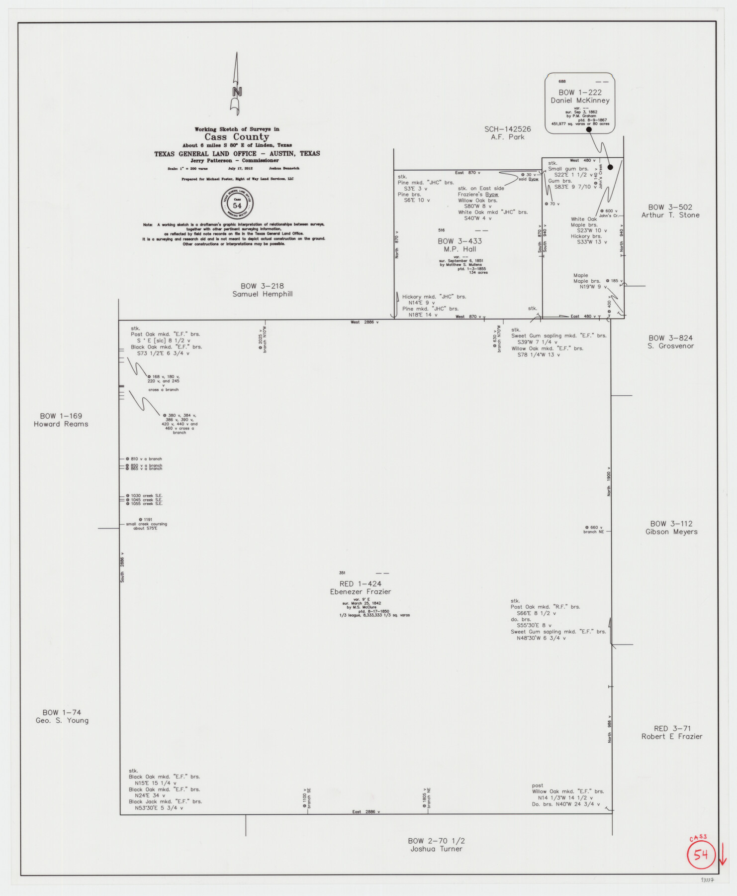
Cass County Working Sketch 54
-
Map/Doc
93337
-
Collection
General Map Collection
-
Object Dates
7/17/2012 (Creation Date)
-
People and Organizations
Joshua Bennetch (Draftsman)
-
Counties
Cass
-
Subjects
Surveying Working Sketch
-
Height x Width
26.2 x 21.6 inches
66.6 x 54.9 cm
-
Scale
1" = 200 varas
Part of: General Map Collection
San Jacinto County Rolled Sketch 12

Print $20.00
- Digital $50.00
San Jacinto County Rolled Sketch 12
1948
Size 24.2 x 32.5 inches
Map/Doc 7561
Coleman County Working Sketch 22

Print $20.00
- Digital $50.00
Coleman County Working Sketch 22
1953
Size 34.6 x 41.0 inches
Map/Doc 68088
Flight Mission No. CRC-4R, Frame 105, Chambers County

Print $20.00
- Digital $50.00
Flight Mission No. CRC-4R, Frame 105, Chambers County
1956
Size 18.8 x 22.4 inches
Map/Doc 84902
Lake Worth Boundary

Print $20.00
- Digital $50.00
Lake Worth Boundary
Size 19.5 x 33.2 inches
Map/Doc 62211
Flight Mission No. DAG-21K, Frame 104, Matagorda County

Print $20.00
- Digital $50.00
Flight Mission No. DAG-21K, Frame 104, Matagorda County
1952
Size 18.7 x 22.3 inches
Map/Doc 86432
Hill County Sketch File 27

Print $4.00
- Digital $50.00
Hill County Sketch File 27
1873
Size 10.4 x 8.2 inches
Map/Doc 26528
Jim Hogg County Sketch File 6a

Print $6.00
- Digital $50.00
Jim Hogg County Sketch File 6a
1939
Size 11.1 x 8.7 inches
Map/Doc 28408
Houston County Rolled Sketch 6

Print $40.00
- Digital $50.00
Houston County Rolled Sketch 6
1963
Size 48.0 x 34.3 inches
Map/Doc 9182
Cottle County Sketch File 18

Print $46.00
- Digital $50.00
Cottle County Sketch File 18
2004
Size 8.0 x 11.0 inches
Map/Doc 82433
Flight Mission No. CLL-1N, Frame 113, Willacy County

Print $20.00
- Digital $50.00
Flight Mission No. CLL-1N, Frame 113, Willacy County
1954
Size 18.3 x 22.0 inches
Map/Doc 87047
Live Oak County Sketch File 20

Print $14.00
- Digital $50.00
Live Oak County Sketch File 20
1898
Size 11.4 x 8.8 inches
Map/Doc 30290
Gregg County Sketch File 2

Print $26.00
- Digital $50.00
Gregg County Sketch File 2
1921
Size 14.2 x 8.7 inches
Map/Doc 24553
You may also like
Upshur County Working Sketch 3

Print $20.00
- Digital $50.00
Upshur County Working Sketch 3
1934
Size 24.6 x 36.3 inches
Map/Doc 69559
Hartley County Sketch File 1

Print $40.00
- Digital $50.00
Hartley County Sketch File 1
Size 9.7 x 18.4 inches
Map/Doc 11696
[Texas and Pacific Railway Company, Block 44, Township One South]
![89846, [Texas and Pacific Railway Company, Block 44, Township One South], Twichell Survey Records](https://historictexasmaps.com/wmedia_w700/maps/89846-1.tif.jpg)
Print $40.00
- Digital $50.00
[Texas and Pacific Railway Company, Block 44, Township One South]
1912
Size 41.1 x 56.4 inches
Map/Doc 89846
P.J. Lawless Addition of part of Outlots 29 and 30, Division D, Austin, Texas

Print $20.00
- Digital $50.00
P.J. Lawless Addition of part of Outlots 29 and 30, Division D, Austin, Texas
1916
Size 13.7 x 17.1 inches
Map/Doc 620
Wood County Working Sketch 1

Print $20.00
- Digital $50.00
Wood County Working Sketch 1
1904
Size 19.7 x 16.2 inches
Map/Doc 62001

Throckmorton County, Texas

Print $20.00
- Digital $50.00
Throckmorton County, Texas
1880
Size 28.8 x 22.5 inches
Map/Doc 627
Hutchinson County Working Sketch Graphic Index - sheet 2

Print $20.00
- Digital $50.00
Hutchinson County Working Sketch Graphic Index - sheet 2
1922
Size 43.8 x 36.7 inches
Map/Doc 76587
Reports of Wm. H. Bourland and James B. Miller, Commissioners to Investigate Land Titles West of the Nueces

Reports of Wm. H. Bourland and James B. Miller, Commissioners to Investigate Land Titles West of the Nueces
1850
Size 17.2 x 12.9 inches
Map/Doc 94259
Lavaca County Working Sketch 26

Print $20.00
- Digital $50.00
Lavaca County Working Sketch 26
1986
Size 25.0 x 28.1 inches
Map/Doc 70379
Edwards County Working Sketch 92

Print $20.00
- Digital $50.00
Edwards County Working Sketch 92
1966
Size 31.8 x 47.5 inches
Map/Doc 68968
Flight Mission No. CRC-3R, Frame 46, Chambers County

Print $20.00
- Digital $50.00
Flight Mission No. CRC-3R, Frame 46, Chambers County
1956
Size 18.6 x 22.5 inches
Map/Doc 84819