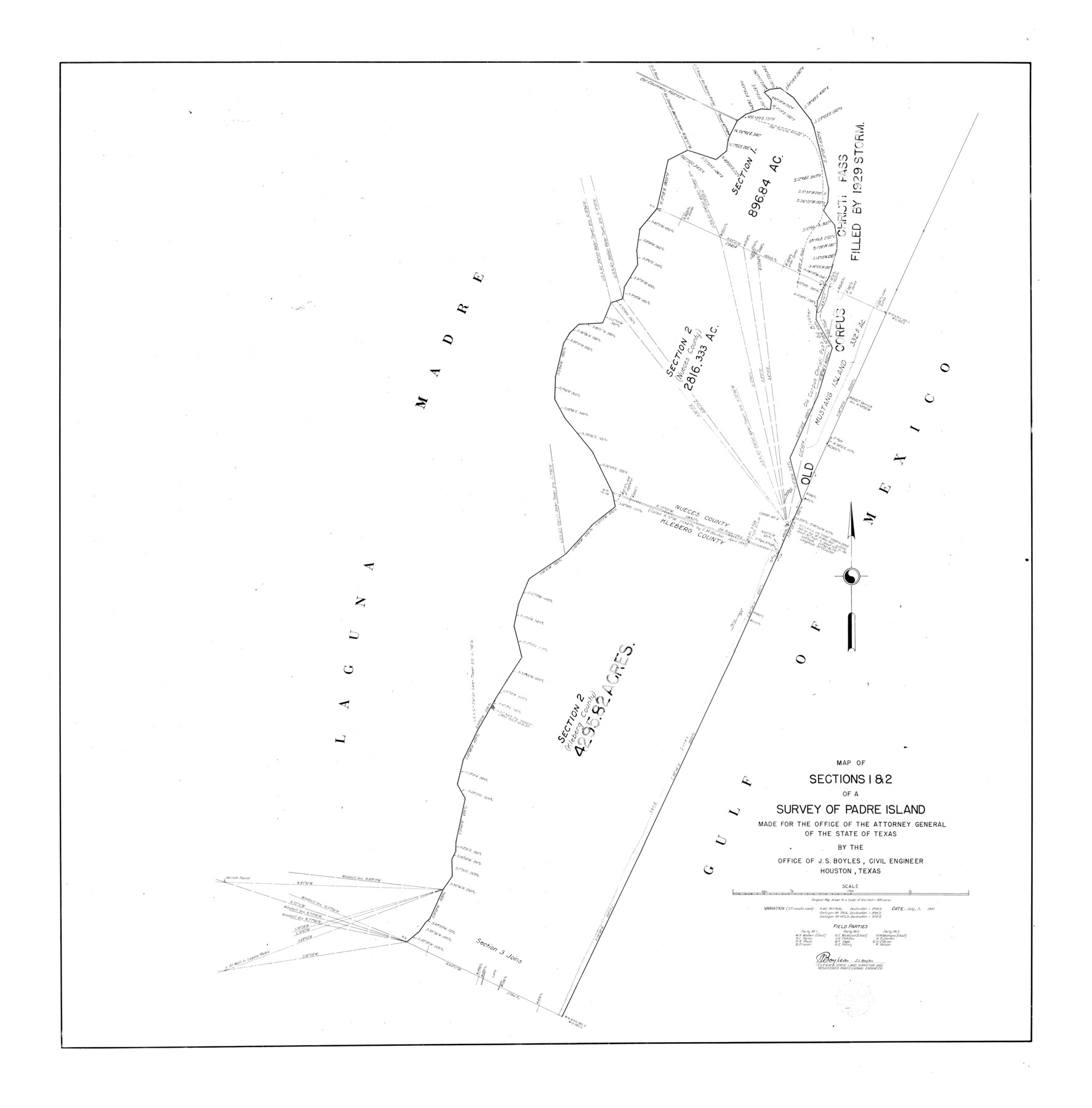
Nueces County Rolled Sketch 45
Map of sections 1 & 2 of a survey of Padre Island made for the Office of the Attorney General of the State of Texas
-
Map/Doc
9603
-
Collection
General Map Collection
-
Object Dates
1941/7/3 (Creation Date)
1974/10/9 (File Date)
-
People and Organizations
J.S. Boyles (Surveyor/Engineer)
-
Counties
Nueces Kleberg
-
Subjects
Surveying Rolled Sketch
-
Height x Width
44.3 x 43.7 inches
112.5 x 111.0 cm
-
Scale
1" = 400 varas
Part of: General Map Collection
Maps & Lists Showing Prison Lands (Oil & Gas) Leased as of June 1955

Digital $50.00
Maps & Lists Showing Prison Lands (Oil & Gas) Leased as of June 1955
Size 11.1 x 9.0 inches
Map/Doc 62872
Flight Mission No. DIX-10P, Frame 73, Aransas County

Print $20.00
- Digital $50.00
Flight Mission No. DIX-10P, Frame 73, Aransas County
1956
Size 18.7 x 22.4 inches
Map/Doc 83934
Flight Mission No. CUG-1P, Frame 41, Kleberg County

Print $20.00
- Digital $50.00
Flight Mission No. CUG-1P, Frame 41, Kleberg County
1956
Size 18.7 x 22.3 inches
Map/Doc 86119
Waller County

Print $40.00
- Digital $50.00
Waller County
1945
Size 48.5 x 28.9 inches
Map/Doc 73315
Cameron County Sketch File 3

Print $42.00
- Digital $50.00
Cameron County Sketch File 3
1930
Size 11.1 x 8.8 inches
Map/Doc 17023
Hardin County Working Sketch 13

Print $20.00
- Digital $50.00
Hardin County Working Sketch 13
1934
Size 25.5 x 17.6 inches
Map/Doc 63411
Pecos County Working Sketch 31

Print $20.00
- Digital $50.00
Pecos County Working Sketch 31
1936
Size 17.5 x 22.4 inches
Map/Doc 71503
Wheeler County Working Sketch 19

Print $20.00
- Digital $50.00
Wheeler County Working Sketch 19
1986
Size 33.5 x 31.8 inches
Map/Doc 72508
Flight Mission No. CLL-1N, Frame 191, Willacy County

Print $20.00
- Digital $50.00
Flight Mission No. CLL-1N, Frame 191, Willacy County
1954
Size 18.3 x 22.0 inches
Map/Doc 87061
Cameron County Rolled Sketch Z1

Print $20.00
- Digital $50.00
Cameron County Rolled Sketch Z1
1937
Size 23.4 x 41.4 inches
Map/Doc 5401
Kimble County Working Sketch 77

Print $20.00
- Digital $50.00
Kimble County Working Sketch 77
1970
Size 25.0 x 36.2 inches
Map/Doc 70145
Dawson County Rolled Sketch 3

Print $20.00
- Digital $50.00
Dawson County Rolled Sketch 3
1903
Size 20.9 x 36.8 inches
Map/Doc 8770
You may also like
Crockett County Sketch File 39

Print $20.00
- Digital $50.00
Crockett County Sketch File 39
1889
Size 19.7 x 32.6 inches
Map/Doc 11221
Sketch of Surveys on Caranchua and Tres Palacious Bayous, Jackson Co.

Print $2.00
- Digital $50.00
Sketch of Surveys on Caranchua and Tres Palacious Bayous, Jackson Co.
Size 7.9 x 7.8 inches
Map/Doc 69743
Map of Hidalgo County

Print $20.00
- Digital $50.00
Map of Hidalgo County
1896
Size 44.9 x 25.5 inches
Map/Doc 4684
Flight Mission No. BRA-3M, Frame 120, Jefferson County

Print $20.00
- Digital $50.00
Flight Mission No. BRA-3M, Frame 120, Jefferson County
1953
Size 18.6 x 22.3 inches
Map/Doc 85394
Collin County Working Sketch 3

Print $20.00
- Digital $50.00
Collin County Working Sketch 3
1935
Size 25.8 x 41.7 inches
Map/Doc 68097
Flight Mission No. DCL-5C, Frame 67, Kenedy County

Print $20.00
- Digital $50.00
Flight Mission No. DCL-5C, Frame 67, Kenedy County
1943
Size 18.5 x 22.2 inches
Map/Doc 85850
[New York, Texas & Mexican Railway]
![64148, [New York, Texas & Mexican Railway], General Map Collection](https://historictexasmaps.com/wmedia_w700/maps/64148.tif.jpg)
Print $20.00
- Digital $50.00
[New York, Texas & Mexican Railway]
Size 12.1 x 24.1 inches
Map/Doc 64148
Hudspeth County Sketch File 11

Print $14.00
- Digital $50.00
Hudspeth County Sketch File 11
Size 14.5 x 8.9 inches
Map/Doc 26903
Cameron County Rolled Sketch 10

Print $20.00
- Digital $50.00
Cameron County Rolled Sketch 10
Size 38.5 x 44.5 inches
Map/Doc 8566
Hunt County Boundary File 10b

Print $4.00
- Digital $50.00
Hunt County Boundary File 10b
Size 11.3 x 8.9 inches
Map/Doc 55264
Red River County Sketch File 23

Print $4.00
- Digital $50.00
Red River County Sketch File 23
1901
Size 11.3 x 8.8 inches
Map/Doc 35157
