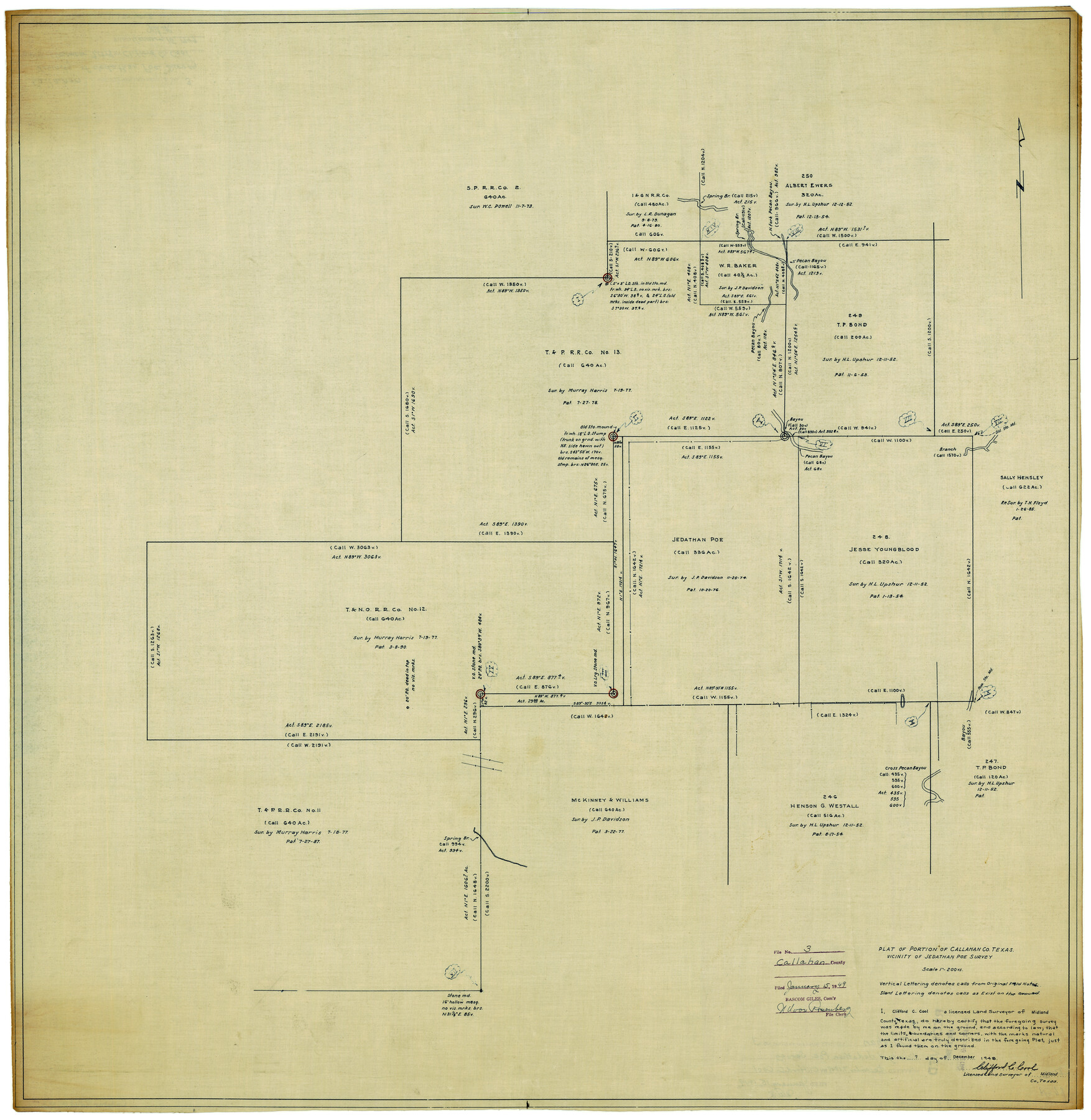
Callahan County Rolled Sketch 3
Plat of portion of Callahan Co. Texas - vicinity of Jedathan Poe survey
-
Map/Doc
8561
-
Collection
General Map Collection
-
Object Dates
12/7/1948 (Creation Date)
1/15/1949 (File Date)
-
People and Organizations
Clifford C. Cool (Surveyor/Engineer)
-
Counties
Callahan
-
Subjects
Surveying Rolled Sketch
-
Height x Width
36.1 x 35.3 inches
91.7 x 89.7 cm
-
Medium
blueprint/diazo
-
Scale
1" = 200 varas
Part of: General Map Collection
Flight Mission No. BRA-3M, Frame 197, Jefferson County

Print $20.00
- Digital $50.00
Flight Mission No. BRA-3M, Frame 197, Jefferson County
1953
Size 18.6 x 22.4 inches
Map/Doc 85412
Sabine County

Print $20.00
- Digital $50.00
Sabine County
1920
Size 44.6 x 35.1 inches
Map/Doc 16805
Lamar County Working Sketch 7

Print $20.00
- Digital $50.00
Lamar County Working Sketch 7
1964
Size 18.7 x 17.6 inches
Map/Doc 70268
Upton County Rolled Sketch 22

Print $20.00
- Digital $50.00
Upton County Rolled Sketch 22
Size 21.6 x 27.0 inches
Map/Doc 8073
Terrell County Sketch File 26

Print $38.00
- Digital $50.00
Terrell County Sketch File 26
1937
Size 10.9 x 8.2 inches
Map/Doc 37961

[T. & G. Ry. Main Line, Texas, Right of Way Map, Center to Gary]
![64571, [T. & G. Ry. Main Line, Texas, Right of Way Map, Center to Gary], General Map Collection](https://historictexasmaps.com/wmedia_w700/maps/64571-1.tif.jpg)
Print $40.00
- Digital $50.00
[T. & G. Ry. Main Line, Texas, Right of Way Map, Center to Gary]
1917
Size 31.9 x 121.1 inches
Map/Doc 64571
Brazoria County Working Sketch 45

Print $20.00
- Digital $50.00
Brazoria County Working Sketch 45
1988
Size 23.0 x 19.2 inches
Map/Doc 67530
Kimble County Working Sketch Graphic Index, Sheet 2 (Sketches 47 to Most Recent)

Print $40.00
- Digital $50.00
Kimble County Working Sketch Graphic Index, Sheet 2 (Sketches 47 to Most Recent)
1930
Size 41.1 x 49.0 inches
Map/Doc 76607
Archer County Sketch File 6

Print $4.00
- Digital $50.00
Archer County Sketch File 6
Size 7.2 x 8.4 inches
Map/Doc 13634
Pecos County Rolled Sketch 19 1/2

Print $20.00
- Digital $50.00
Pecos County Rolled Sketch 19 1/2
1885
Size 41.9 x 17.6 inches
Map/Doc 7208
Flight Mission No. DIX-10P, Frame 168, Aransas County

Print $20.00
- Digital $50.00
Flight Mission No. DIX-10P, Frame 168, Aransas County
1956
Size 18.7 x 22.3 inches
Map/Doc 83958
You may also like
Marion County Working Sketch 29

Print $20.00
- Digital $50.00
Marion County Working Sketch 29
1977
Size 20.4 x 16.1 inches
Map/Doc 70805
Upton County Working Sketch 29

Print $40.00
- Digital $50.00
Upton County Working Sketch 29
1956
Size 50.6 x 36.0 inches
Map/Doc 69525
[Pencil sketch of Wm. Rivers survey]
![91969, [Pencil sketch of Wm. Rivers survey], Twichell Survey Records](https://historictexasmaps.com/wmedia_w700/maps/91969-1.tif.jpg)
Print $3.00
- Digital $50.00
[Pencil sketch of Wm. Rivers survey]
Size 9.9 x 16.1 inches
Map/Doc 91969
Orange County Sketch File 14

Print $20.00
- Digital $50.00
Orange County Sketch File 14
Size 19.9 x 32.9 inches
Map/Doc 12118
Hall County Sketch File 2

Print $12.00
- Digital $50.00
Hall County Sketch File 2
1880
Size 17.1 x 8.4 inches
Map/Doc 42261
Kinney County Working Sketch 44

Print $20.00
- Digital $50.00
Kinney County Working Sketch 44
1978
Size 36.7 x 25.8 inches
Map/Doc 70226
Pecos County Boundary File 1b

Print $8.00
- Digital $50.00
Pecos County Boundary File 1b
Size 14.2 x 8.5 inches
Map/Doc 57861
Flight Mission No. BQY-4M, Frame 65, Harris County

Print $20.00
- Digital $50.00
Flight Mission No. BQY-4M, Frame 65, Harris County
1953
Size 18.7 x 22.4 inches
Map/Doc 85274
Hemphill County Sketch file 6b

Print $20.00
- Digital $50.00
Hemphill County Sketch file 6b
1903
Size 13.7 x 24.3 inches
Map/Doc 11752
The Republic County of Jasper. January 29, 1842

Print $20.00
The Republic County of Jasper. January 29, 1842
2020
Size 19.5 x 21.7 inches
Map/Doc 96194
Val Verde County

Print $20.00
- Digital $50.00
Val Verde County
1944
Size 42.3 x 37.8 inches
Map/Doc 73311
Matagorda County Rolled Sketch 31

Print $187.00
- Digital $50.00
Matagorda County Rolled Sketch 31
Size 10.6 x 15.5 inches
Map/Doc 46654