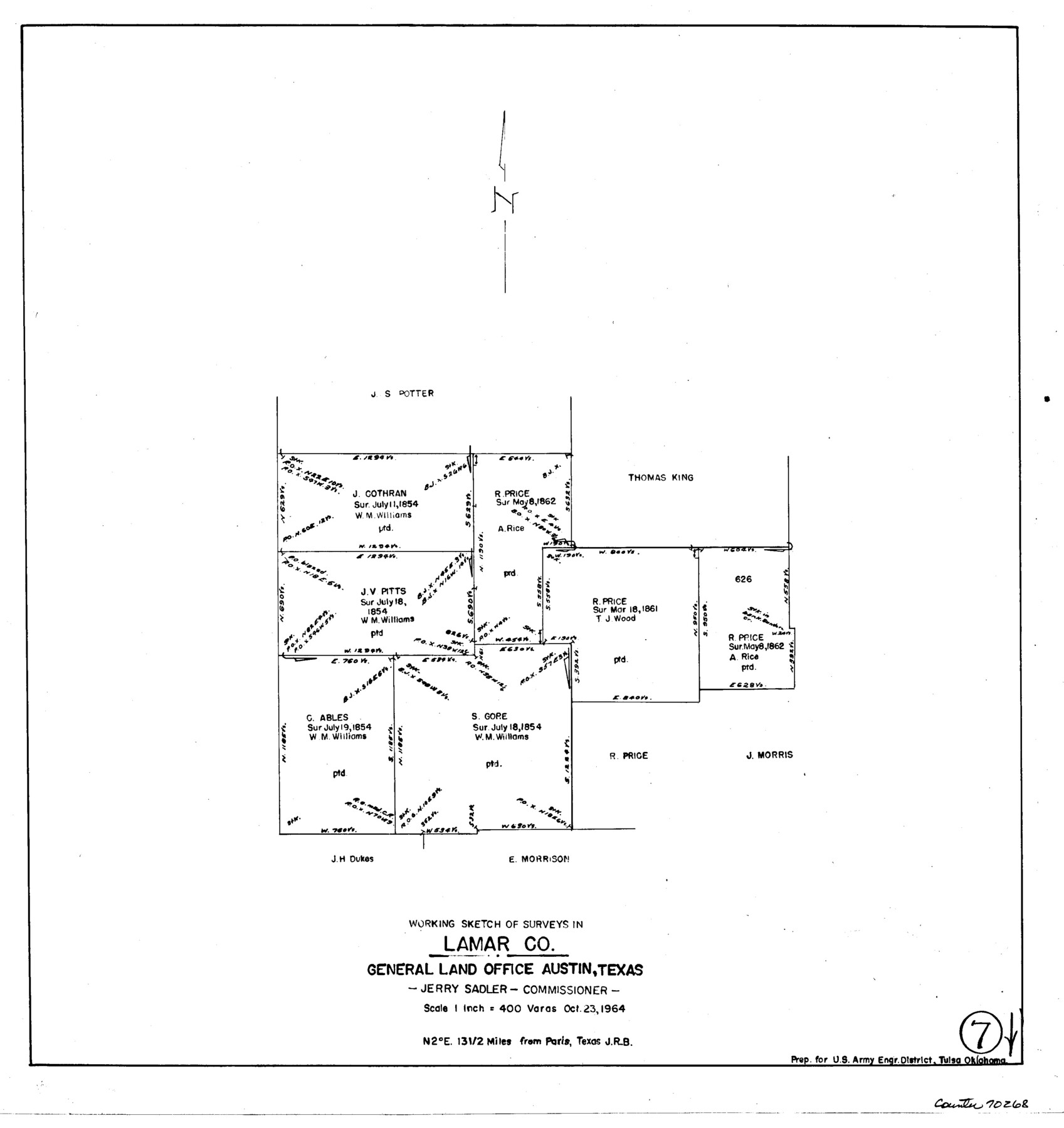
Lamar County Working Sketch 7
-
Map/Doc
70268
-
Collection
General Map Collection
-
Object Dates
10/23/1964 (Creation Date)
-
Counties
Lamar
-
Subjects
Surveying Working Sketch
-
Height x Width
18.7 x 17.6 inches
47.5 x 44.7 cm
-
Scale
1" = 400 varas
Part of: General Map Collection
Nueces County Rolled Sketch 57

Print $48.00
Nueces County Rolled Sketch 57
1979
Size 18.9 x 24.6 inches
Map/Doc 6897
Menard County Sketch File 3

Print $40.00
- Digital $50.00
Menard County Sketch File 3
Size 16.3 x 12.9 inches
Map/Doc 31488
Southern Part of Laguna Madre

Print $20.00
- Digital $50.00
Southern Part of Laguna Madre
1985
Size 45.3 x 36.6 inches
Map/Doc 73547
Limestone County Sketch File 4

Print $20.00
- Digital $50.00
Limestone County Sketch File 4
1847
Size 15.2 x 34.1 inches
Map/Doc 12001
[Jose Antonio Sepulveda grant]
![349, [Jose Antonio Sepulveda grant], General Map Collection](https://historictexasmaps.com/wmedia_w700/maps/349.tif.jpg)
Print $2.00
- Digital $50.00
[Jose Antonio Sepulveda grant]
Size 5.9 x 5.7 inches
Map/Doc 349
Tarrant County Boundary File 82

Print $22.00
- Digital $50.00
Tarrant County Boundary File 82
Size 8.9 x 7.0 inches
Map/Doc 59173
Right of Way & Track Map San Antonio & Aransas Pass Railway Co.

Print $40.00
- Digital $50.00
Right of Way & Track Map San Antonio & Aransas Pass Railway Co.
1919
Size 25.6 x 57.0 inches
Map/Doc 64025
Jack County Sketch File 8a

Print $6.00
- Digital $50.00
Jack County Sketch File 8a
1855
Size 8.1 x 10.6 inches
Map/Doc 27519
Flight Mission No. BRE-2P, Frame 67, Nueces County

Print $20.00
- Digital $50.00
Flight Mission No. BRE-2P, Frame 67, Nueces County
1956
Size 18.5 x 22.3 inches
Map/Doc 86762
Maps & Lists Showing Prison Lands (Oil & Gas) Leased as of June 1955

Digital $50.00
Maps & Lists Showing Prison Lands (Oil & Gas) Leased as of June 1955
Size 11.2 x 8.7 inches
Map/Doc 62871
Calcasieu Pass to Sabine Pass

Print $20.00
- Digital $50.00
Calcasieu Pass to Sabine Pass
1943
Size 44.5 x 35.1 inches
Map/Doc 69805
Kerr County Sketch File 8

Print $4.00
- Digital $50.00
Kerr County Sketch File 8
1882
Size 12.6 x 8.1 inches
Map/Doc 28871
You may also like
Goliad County Sketch File 28

Print $20.00
- Digital $50.00
Goliad County Sketch File 28
Size 18.9 x 15.5 inches
Map/Doc 11569
Karnes County Rolled Sketch 4

Print $20.00
- Digital $50.00
Karnes County Rolled Sketch 4
1961
Size 33.4 x 37.7 inches
Map/Doc 9667
McMullen County Working Sketch 5

Print $20.00
- Digital $50.00
McMullen County Working Sketch 5
1923
Size 21.8 x 19.0 inches
Map/Doc 70706
[Sketch showing Panhandle and Santa Fe Railroad, Compress Spur and Seed House structures]
![92880, [Sketch showing Panhandle and Santa Fe Railroad, Compress Spur and Seed House structures], Twichell Survey Records](https://historictexasmaps.com/wmedia_w700/maps/92880-1.tif.jpg)
Print $20.00
- Digital $50.00
[Sketch showing Panhandle and Santa Fe Railroad, Compress Spur and Seed House structures]
Size 20.8 x 22.8 inches
Map/Doc 92880
Sutton County Sketch File 27

Print $20.00
- Digital $50.00
Sutton County Sketch File 27
Size 38.8 x 15.1 inches
Map/Doc 10377
Uvalde County Working Sketch 24

Print $20.00
- Digital $50.00
Uvalde County Working Sketch 24
1954
Size 21.7 x 23.3 inches
Map/Doc 72094
Loving County Rolled Sketch 5

Print $40.00
- Digital $50.00
Loving County Rolled Sketch 5
1952
Size 146.0 x 14.2 inches
Map/Doc 9467
Hardeman County Boundary File 3a

Print $42.00
- Digital $50.00
Hardeman County Boundary File 3a
Size 56.8 x 12.3 inches
Map/Doc 54384
Sabine County Sketch File 2

Print $4.00
Sabine County Sketch File 2
Size 10.0 x 7.9 inches
Map/Doc 35602
Stonewall County Rolled Sketch 23

Print $20.00
- Digital $50.00
Stonewall County Rolled Sketch 23
Size 38.5 x 47.5 inches
Map/Doc 9962
Somervell County

Print $20.00
- Digital $50.00
Somervell County
1884
Size 29.5 x 31.3 inches
Map/Doc 63041
Montgomery County

Print $20.00
- Digital $50.00
Montgomery County
1901
Size 42.8 x 45.9 inches
Map/Doc 10794