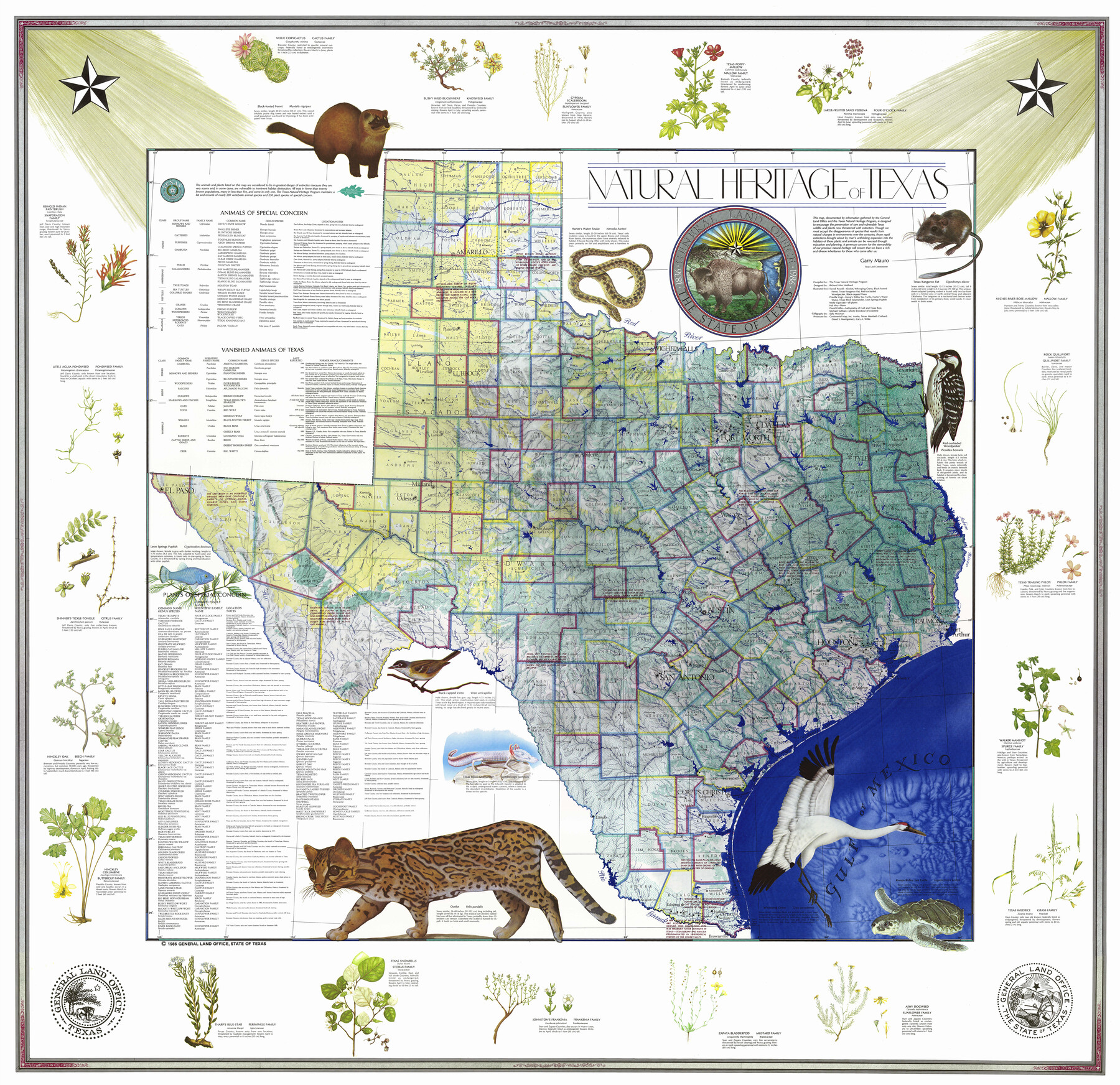
Natural Heritage of Texas
- 
                          Map/Doc10786
- 
                            CollectionGeneral Map Collection
- 
                            Object Dates1986 (Creation Date)
- 
                            People and OrganizationsGeneral Land Office (Publisher)Garry Mauro (GLO Commissioner)The Texas Natural Heritage Program (Compiler)Richard Alan Hubbard (Cartographer)Terrell Powell (Illustrator)Priscilla Vogt (Illustrator)Molly Ogorzaly (Illustrator)Hal Irby (Illustrator)David Griffin (Illustrator)Michael Sullivan (Illustrator)Sally Hickman (Letterer)David S. Montgomery (Producer)Cary A. Wilke (Producer)Merideth Gothard (Producer)
- 
                            SubjectsPictorial State of Texas
- 
                            Height x Width54.3 x 56.0 inches137.9 x 142.2 cm
- 
                            Mediumpaper, etching/engraving/lithograph
- 
                            URLshttps://medium.com/@txglo/my-favorite-map-the-natural-heritage-map-of-texas-1986-53861aac4ea0#.yf8czbig4
Part of: General Map Collection
            Yoakum County Rolled Sketch 1


                                            Print $20.00                    
                                             -                         Digital $50.00                                    
                Yoakum County Rolled Sketch 1
1939
Size 40.5 x 37.5 inches
                                Map/Doc 10162
            
            Galveston County Rolled Sketch 30


                                            Print $20.00                    
                                             -                         Digital $50.00                                    
                Galveston County Rolled Sketch 30
1979
Size 28.0 x 39.8 inches
                                Map/Doc 5964
            
            Aransas County Working Sketch 23


                                            Print $20.00                    
                                             -                         Digital $50.00                                    
                Aransas County Working Sketch 23
1970
Size 34.6 x 40.1 inches
                                Map/Doc 67190
            
            Jefferson County Sketch file 30


                                            Print $22.00                    
                                             -                         Digital $50.00                                    
                Jefferson County Sketch file 30
1917
Size 11.2 x 8.8 inches
                                Map/Doc 28194
            
            Flight Mission No. DQN-6K, Frame 72, Calhoun County


                                            Print $20.00                    
                                             -                         Digital $50.00                                    
                Flight Mission No. DQN-6K, Frame 72, Calhoun County
1953
Size 18.4 x 22.0 inches
                                Map/Doc 84444
            
            Flight Mission No. CLL-3N, Frame 33, Willacy County


                                            Print $20.00                    
                                             -                         Digital $50.00                                    
                Flight Mission No. CLL-3N, Frame 33, Willacy County
1954
Size 18.6 x 22.3 inches
                                Map/Doc 87090
            
            [Right of Way & Track Map, The Texas & Pacific Ry. Co. Main Line]
            
                                    ![64661, [Right of Way & Track Map, The Texas & Pacific Ry. Co. Main Line], General Map Collection](https://historictexasmaps.com/wmedia_w700/maps/64661.tif.jpg) 


    ![64661, [Right of Way & Track Map, The Texas & Pacific Ry. Co. Main Line], General Map Collection](https://historictexasmaps.com/wmedia_w700/maps/64661.tif.jpg) 
                                
            
                                            Print $20.00                    
                                             -                         Digital $50.00                                    
                [Right of Way & Track Map, The Texas & Pacific Ry. Co. Main Line]
Size 11.0 x 18.6 inches
                                Map/Doc 64661
            
            [Right of Way & Track Map, The Texas & Pacific Ry. Co. Main Line]
            
                                    ![64681, [Right of Way & Track Map, The Texas & Pacific Ry. Co. Main Line], General Map Collection](https://historictexasmaps.com/wmedia_w700/maps/64681.tif.jpg) 


    ![64681, [Right of Way & Track Map, The Texas & Pacific Ry. Co. Main Line], General Map Collection](https://historictexasmaps.com/wmedia_w700/maps/64681.tif.jpg) 
                                
            
                                            Print $20.00                    
                                             -                         Digital $50.00                                    
                [Right of Way & Track Map, The Texas & Pacific Ry. Co. Main Line]
Size 11.0 x 19.0 inches
                                Map/Doc 64681
            
            Trinity River, Levee Improvement Districts, Widths of Floodways


                                            Print $4.00                    
                                             -                         Digital $50.00                                    
                Trinity River, Levee Improvement Districts, Widths of Floodways
1919
Size 23.5 x 17.6 inches
                                Map/Doc 65250
            
            Map of the State of Texas Showing Original Land Districts


                                            Print $20.00                    
                                             -                         Digital $50.00                                    
                Map of the State of Texas Showing Original Land Districts
1891
Size 42.2 x 42.4 inches
                                Map/Doc 2138
            
            Presidio County Rolled Sketch 6


                                            Print $20.00                    
                                             -                         Digital $50.00                                    
                Presidio County Rolled Sketch 6
Size 33.0 x 20.6 inches
                                Map/Doc 7330
            
            Intracoastal Waterway in Texas - Corpus Christi to Point Isabel including Arroyo Colorado to Mo. Pac. R.R. Bridge Near Harlingen


                                            Print $20.00                    
                                             -                         Digital $50.00                                    
                Intracoastal Waterway in Texas - Corpus Christi to Point Isabel including Arroyo Colorado to Mo. Pac. R.R. Bridge Near Harlingen
1933
Size 28.2 x 40.7 inches
                                Map/Doc 61856
            You may also like
            Jefferson County Rolled Sketch 64


                                            Print $20.00                    
                                             -                         Digital $50.00                                    
                Jefferson County Rolled Sketch 64
1982
Size 26.7 x 37.4 inches
                                Map/Doc 9319
            
            Hardin County Working Sketch 5


                                            Print $20.00                    
                                             -                         Digital $50.00                                    
                Hardin County Working Sketch 5
1921
Size 31.0 x 22.0 inches
                                Map/Doc 63403
            
            General Highway Map, King County, Texas


                                            Print $20.00                    
                                    
                General Highway Map, King County, Texas
1940
Size 18.3 x 24.8 inches
                                Map/Doc 79161
            
            Kinney County


                                            Print $40.00                    
                                             -                         Digital $50.00                                    
                Kinney County
1909
Size 49.8 x 44.2 inches
                                Map/Doc 66893
            
            Winkler County Working Sketch 3


                                            Print $40.00                    
                                             -                         Digital $50.00                                    
                Winkler County Working Sketch 3
1944
Size 43.5 x 60.5 inches
                                Map/Doc 72597
            
            Upton County Working Sketch 23


                                            Print $20.00                    
                                             -                         Digital $50.00                                    
                Upton County Working Sketch 23
1953
Size 21.4 x 20.0 inches
                                Map/Doc 69519
            
            Hamilton County


                                            Print $20.00                    
                                             -                         Digital $50.00                                    
                Hamilton County
1916
Size 41.4 x 40.5 inches
                                Map/Doc 66851
            
            Hunt County Working Sketch 11


                                            Print $20.00                    
                                             -                         Digital $50.00                                    
                Hunt County Working Sketch 11
2002
Size 32.1 x 29.6 inches
                                Map/Doc 66358
            
            Working Sketch in Gray and Donley Counties


                                            Print $20.00                    
                                             -                         Digital $50.00                                    
                Working Sketch in Gray and Donley Counties
1910
Size 28.4 x 26.7 inches
                                Map/Doc 90707
            
            Ector County Rolled Sketch 12


                                            Print $38.00                    
                                             -                         Digital $50.00                                    
                Ector County Rolled Sketch 12
Size 10.1 x 15.4 inches
                                Map/Doc 44314
             
                         
                                