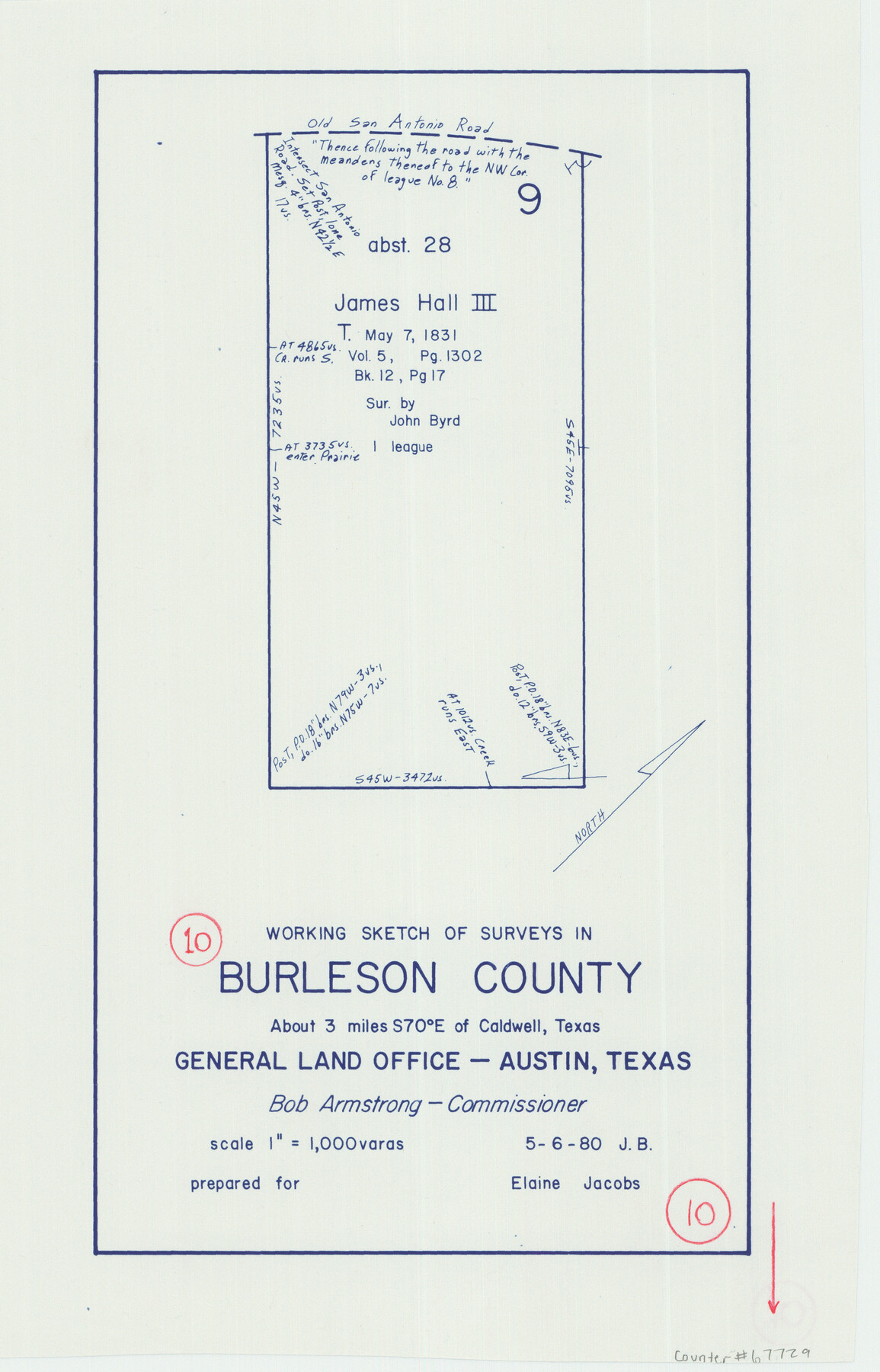
Burleson County Working Sketch 10
-
Map/Doc
67729
-
Collection
General Map Collection
-
Object Dates
5/6/1980 (Creation Date)
-
Counties
Burleson
-
Subjects
Surveying Working Sketch
-
Height x Width
15.1 x 9.7 inches
38.4 x 24.6 cm
-
Scale
1" = 1000 varas
Part of: General Map Collection
Flight Mission No. CUG-1P, Frame 50, Kleberg County

Print $20.00
- Digital $50.00
Flight Mission No. CUG-1P, Frame 50, Kleberg County
1956
Size 18.6 x 22.3 inches
Map/Doc 86128
Culberson County Working Sketch 80

Print $40.00
- Digital $50.00
Culberson County Working Sketch 80
1978
Size 56.4 x 43.4 inches
Map/Doc 68534
Flight Mission No. DQN-2K, Frame 160, Calhoun County

Print $20.00
- Digital $50.00
Flight Mission No. DQN-2K, Frame 160, Calhoun County
1953
Size 18.6 x 22.3 inches
Map/Doc 84322
Map of the State of Texas

Print $40.00
- Digital $50.00
Map of the State of Texas
1879
Size 102.3 x 56.2 inches
Map/Doc 93384
Corpus Christi Harbor

Print $40.00
- Digital $50.00
Corpus Christi Harbor
1972
Size 36.9 x 52.3 inches
Map/Doc 73477
Dimmit County Working Sketch 21

Print $20.00
- Digital $50.00
Dimmit County Working Sketch 21
1950
Size 35.1 x 18.8 inches
Map/Doc 68682
Parker County Sketch File 16

Print $22.00
- Digital $50.00
Parker County Sketch File 16
1870
Size 12.9 x 16.3 inches
Map/Doc 33550
[Surveys near the city of Bastrop]
![107, [Surveys near the city of Bastrop], General Map Collection](https://historictexasmaps.com/wmedia_w700/maps/107.tif.jpg)
Print $2.00
- Digital $50.00
[Surveys near the city of Bastrop]
1841
Size 6.5 x 7.0 inches
Map/Doc 107
Hutchinson County Rolled Sketch 44-18

Print $20.00
- Digital $50.00
Hutchinson County Rolled Sketch 44-18
2002
Size 24.0 x 36.0 inches
Map/Doc 77554
San Patricio County Sketch File 32

Print $20.00
- Digital $50.00
San Patricio County Sketch File 32
Size 13.7 x 30.3 inches
Map/Doc 12287
Brazoria County Working Sketch 49b

Print $20.00
- Digital $50.00
Brazoria County Working Sketch 49b
2003
Size 34.9 x 35.3 inches
Map/Doc 78348
Right of Way and Track Map Texas & New Orleans R.R. Co. operated by the T. & N. O. R.R. Co. Dallas-Sabine Branch

Print $40.00
- Digital $50.00
Right of Way and Track Map Texas & New Orleans R.R. Co. operated by the T. & N. O. R.R. Co. Dallas-Sabine Branch
1918
Size 26.1 x 56.7 inches
Map/Doc 64150
You may also like
Angelina County Sketch File 8

Print $22.00
- Digital $50.00
Angelina County Sketch File 8
1858
Size 8.0 x 3.5 inches
Map/Doc 12935
Scurry County Sketch File 6

Print $14.00
- Digital $50.00
Scurry County Sketch File 6
2002
Size 11.2 x 8.7 inches
Map/Doc 76370
Winkler County

Print $20.00
- Digital $50.00
Winkler County
1932
Size 39.7 x 38.5 inches
Map/Doc 95678
Pecos County Working Sketch 71

Print $20.00
- Digital $50.00
Pecos County Working Sketch 71
1957
Size 41.6 x 26.0 inches
Map/Doc 71543
Brazos River, Brazos River Sheet 7

Print $6.00
- Digital $50.00
Brazos River, Brazos River Sheet 7
1926
Size 24.1 x 30.6 inches
Map/Doc 65300
Maverick County Sketch File 6

Print $8.00
- Digital $50.00
Maverick County Sketch File 6
Size 12.7 x 8.2 inches
Map/Doc 31053
Montgomery County Sketch File 22

Print $12.00
- Digital $50.00
Montgomery County Sketch File 22
1839
Size 8.8 x 7.6 inches
Map/Doc 31860
Texas Intracoastal Waterway - Matagorda Bay, Cedar Lakes to Oyster Lake

Print $20.00
- Digital $50.00
Texas Intracoastal Waterway - Matagorda Bay, Cedar Lakes to Oyster Lake
1956
Size 27.3 x 38.9 inches
Map/Doc 73367
Sutton County Working Sketch 13

Print $40.00
- Digital $50.00
Sutton County Working Sketch 13
1972
Size 58.8 x 37.0 inches
Map/Doc 62356
Hardin County Sketch File 49

Print $4.00
- Digital $50.00
Hardin County Sketch File 49
1904
Size 14.5 x 8.8 inches
Map/Doc 25202
Flight Mission No. BQR-13K, Frame 22, Brazoria County

Print $20.00
- Digital $50.00
Flight Mission No. BQR-13K, Frame 22, Brazoria County
1952
Size 18.9 x 22.4 inches
Map/Doc 84070
Burnet County Working Sketch 18

Print $20.00
- Digital $50.00
Burnet County Working Sketch 18
1980
Size 44.3 x 32.9 inches
Map/Doc 67861