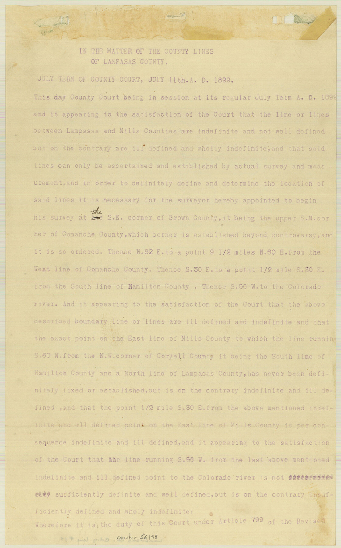
Lampasas County Boundary File 14
Order of Court Lampasas & Mills County Boundary line
-
Map/Doc
56198
-
Collection
General Map Collection
-
Counties
Lampasas
-
Subjects
County Boundaries
-
Height x Width
13.3 x 8.3 inches
33.8 x 21.1 cm
Part of: General Map Collection
Starr County Sketch File 38

Print $8.00
- Digital $50.00
Starr County Sketch File 38
1940
Size 14.2 x 8.8 inches
Map/Doc 36985
Flight Mission No. CGI-3N, Frame 160, Cameron County

Print $20.00
- Digital $50.00
Flight Mission No. CGI-3N, Frame 160, Cameron County
1954
Size 18.5 x 22.3 inches
Map/Doc 84624
Cass County Working Sketch 19

Print $20.00
- Digital $50.00
Cass County Working Sketch 19
1959
Size 27.2 x 29.3 inches
Map/Doc 67922
[Surveys in the Bexar District along the Colorado River]
![38, [Surveys in the Bexar District along the Colorado River], General Map Collection](https://historictexasmaps.com/wmedia_w700/maps/38.tif.jpg)
Print $2.00
- Digital $50.00
[Surveys in the Bexar District along the Colorado River]
1841
Size 7.2 x 9.1 inches
Map/Doc 38
Duval County Sketch File 51

Print $20.00
- Digital $50.00
Duval County Sketch File 51
Size 19.1 x 33.8 inches
Map/Doc 11401
United States Atlantic and Gulf Coasts Including Puerto Rico and the Virgin Islands

Print $40.00
- Digital $50.00
United States Atlantic and Gulf Coasts Including Puerto Rico and the Virgin Islands
1973
Size 21.9 x 60.6 inches
Map/Doc 76125
San Patricio County Sketch File 28

Print $53.00
San Patricio County Sketch File 28
1935
Size 9.4 x 7.0 inches
Map/Doc 36087
Runnels County Working Sketch 13

Print $20.00
- Digital $50.00
Runnels County Working Sketch 13
1950
Size 19.4 x 17.8 inches
Map/Doc 63609
Victoria County Working Sketch 11

Print $20.00
- Digital $50.00
Victoria County Working Sketch 11
2004
Size 34.7 x 36.0 inches
Map/Doc 83591
Flight Mission No. BQR-13K, Frame 123, Brazoria County

Print $20.00
- Digital $50.00
Flight Mission No. BQR-13K, Frame 123, Brazoria County
1952
Size 18.7 x 22.4 inches
Map/Doc 84084
Webb County Working Sketch 2

Print $20.00
- Digital $50.00
Webb County Working Sketch 2
1906
Size 11.2 x 12.5 inches
Map/Doc 72367
Outer Continental Shelf Leasing Maps (Louisiana Offshore Operations)

Print $20.00
- Digital $50.00
Outer Continental Shelf Leasing Maps (Louisiana Offshore Operations)
1971
Size 20.2 x 15.0 inches
Map/Doc 76092
You may also like
Duval County Boundary File 2

Print $32.00
- Digital $50.00
Duval County Boundary File 2
Size 12.4 x 8.1 inches
Map/Doc 52703
[Movements & Objectives of the 143rd & 144th Infantry on October 12-13, 1918] - Verso
![94136, [Movements & Objectives of the 143rd & 144th Infantry on October 12-13, 1918] - Verso, Non-GLO Digital Images](https://historictexasmaps.com/wmedia_w700/maps/94136-1.tif.jpg)
Print $20.00
[Movements & Objectives of the 143rd & 144th Infantry on October 12-13, 1918] - Verso
1918
Size 42.4 x 30.0 inches
Map/Doc 94136
Marion County Working Sketch 44

Print $20.00
- Digital $50.00
Marion County Working Sketch 44
2002
Size 42.7 x 27.0 inches
Map/Doc 78215
El Paso County Working Sketch 33

Print $20.00
- Digital $50.00
El Paso County Working Sketch 33
1974
Size 33.7 x 20.3 inches
Map/Doc 69055
Donley County Sketch File B3

Print $20.00
- Digital $50.00
Donley County Sketch File B3
1918
Size 22.0 x 15.0 inches
Map/Doc 11373
Scurry County Sketch File 6

Print $14.00
- Digital $50.00
Scurry County Sketch File 6
2002
Size 11.2 x 8.7 inches
Map/Doc 76370
Van Zandt County Sketch File 33

Print $8.00
- Digital $50.00
Van Zandt County Sketch File 33
1860
Size 12.4 x 7.8 inches
Map/Doc 39469
Angelina County Sketch File 3

Print $8.00
- Digital $50.00
Angelina County Sketch File 3
Size 7.7 x 7.6 inches
Map/Doc 12922
Motley County Sketch File 16 (N)

Print $16.00
- Digital $50.00
Motley County Sketch File 16 (N)
1911
Size 11.0 x 8.6 inches
Map/Doc 32052
Jefferson County Rolled Sketch 61C

Print $20.00
- Digital $50.00
Jefferson County Rolled Sketch 61C
1928
Size 27.2 x 40.3 inches
Map/Doc 6412
Flight Mission No. DQN-1K, Frame 72, Calhoun County

Print $20.00
- Digital $50.00
Flight Mission No. DQN-1K, Frame 72, Calhoun County
1953
Size 18.4 x 22.3 inches
Map/Doc 84159
Polk County Sketch File 12a

Print $4.00
- Digital $50.00
Polk County Sketch File 12a
Size 6.1 x 6.4 inches
Map/Doc 34148