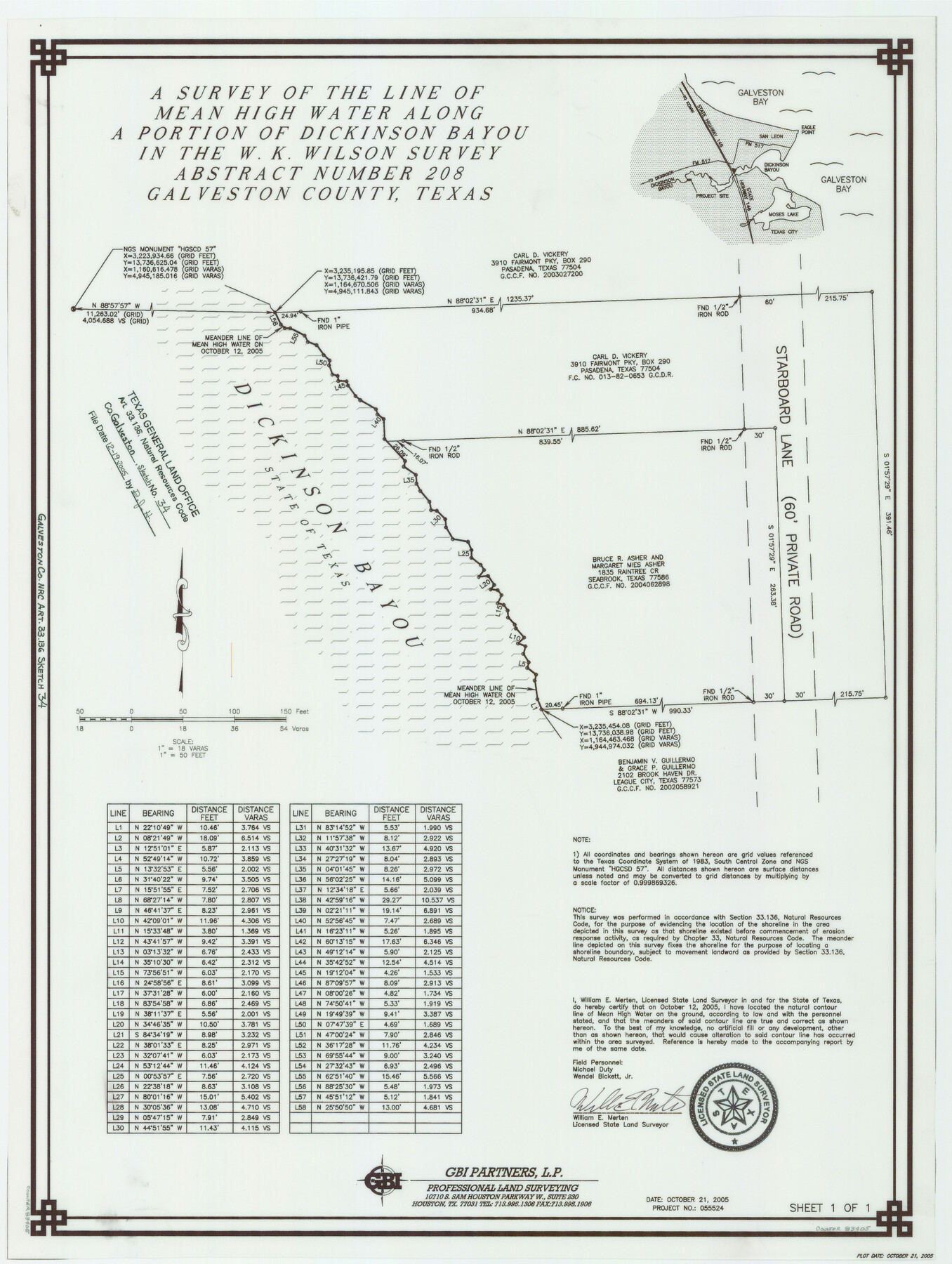
Galveston County NRC Article 33.136 Sketch 34
A Survey of the Line of Mean High Water along a Portion of Dickinson Bayou in the W. K. Wilson Survey Abstract 208
-
Map/Doc
83405
-
Collection
General Map Collection
-
Object Dates
2005/10/21 (Creation Date)
2005/12/19 (File Date)
-
People and Organizations
GBI Partners, L. P. (Publisher)
GBI Partners, L. P. (Printer)
William E. Merten (Surveyor/Engineer)
-
Counties
Galveston
-
Subjects
Surveying CBS
-
Height x Width
24.5 x 18.5 inches
62.2 x 47.0 cm
-
Medium
mylar, print
-
Comments
Survey located about 17 1/2 miles North 50 degrees West of Galveston, Texas.
Part of: General Map Collection
Midland County Working Sketch 5

Print $20.00
- Digital $50.00
Midland County Working Sketch 5
1893
Size 31.2 x 25.6 inches
Map/Doc 70985
Fractional Township No. 9 South Range No. 2 East of the Indian Meridian, Indian Territory

Print $20.00
- Digital $50.00
Fractional Township No. 9 South Range No. 2 East of the Indian Meridian, Indian Territory
1898
Size 19.1 x 24.2 inches
Map/Doc 75203
Live Oak County Working Sketch Graphic Index

Print $40.00
- Digital $50.00
Live Oak County Working Sketch Graphic Index
1947
Size 53.7 x 39.4 inches
Map/Doc 76623
Oldham County Rolled Sketch 12

Print $20.00
- Digital $50.00
Oldham County Rolled Sketch 12
1981
Size 25.2 x 38.0 inches
Map/Doc 7177
[Right of Way & Track Map, The Texas & Pacific Ry. Co. Main Line]
![64665, [Right of Way & Track Map, The Texas & Pacific Ry. Co. Main Line], General Map Collection](https://historictexasmaps.com/wmedia_w700/maps/64665.tif.jpg)
Print $20.00
- Digital $50.00
[Right of Way & Track Map, The Texas & Pacific Ry. Co. Main Line]
Size 11.0 x 18.4 inches
Map/Doc 64665
Real County Sketch File 18

Print $28.00
- Digital $50.00
Real County Sketch File 18
1964
Size 14.3 x 8.9 inches
Map/Doc 35076
Val Verde County Working Sketch 87

Print $20.00
- Digital $50.00
Val Verde County Working Sketch 87
1973
Size 37.1 x 33.8 inches
Map/Doc 72222
Erath County Working Sketch 36

Print $20.00
- Digital $50.00
Erath County Working Sketch 36
1973
Size 33.5 x 30.4 inches
Map/Doc 69117
Township No. 5 South Range No. 11 West of the Indian Meridian

Print $20.00
- Digital $50.00
Township No. 5 South Range No. 11 West of the Indian Meridian
1875
Size 19.3 x 24.3 inches
Map/Doc 75160
Presidio County Sketch File 38

Print $8.00
- Digital $50.00
Presidio County Sketch File 38
1911
Size 11.2 x 8.7 inches
Map/Doc 34508
Newton County Sketch File 17

Print $3.00
- Digital $50.00
Newton County Sketch File 17
1884
Size 15.5 x 10.6 inches
Map/Doc 32392
[Sketch for Mineral Application 27670 - Strip between Simon Sanchez leagues and Trinity River]
![65645, [Sketch for Mineral Application 27670 - Strip between Simon Sanchez leagues and Trinity River], General Map Collection](https://historictexasmaps.com/wmedia_w700/maps/65645.tif.jpg)
Print $40.00
- Digital $50.00
[Sketch for Mineral Application 27670 - Strip between Simon Sanchez leagues and Trinity River]
Size 17.5 x 55.2 inches
Map/Doc 65645
You may also like
Navarro County Working Sketch 1c

Print $2.00
- Digital $50.00
Navarro County Working Sketch 1c
Size 7.1 x 10.6 inches
Map/Doc 71231
Frio County Working Sketch 13

Print $20.00
- Digital $50.00
Frio County Working Sketch 13
1954
Size 23.3 x 35.5 inches
Map/Doc 69287
Kaufman County Sketch File 9

Print $8.00
- Digital $50.00
Kaufman County Sketch File 9
1851
Size 9.7 x 7.9 inches
Map/Doc 28640
Webb County Working Sketch 31

Print $20.00
- Digital $50.00
Webb County Working Sketch 31
1937
Size 23.2 x 26.0 inches
Map/Doc 72396
Yoakum-Terry County Sketch

Print $20.00
- Digital $50.00
Yoakum-Terry County Sketch
Size 9.4 x 27.3 inches
Map/Doc 91977
Bee County Sketch File 2

Print $40.00
- Digital $50.00
Bee County Sketch File 2
Size 14.3 x 13.0 inches
Map/Doc 14259
Roberts County Working Sketch 19

Print $20.00
- Digital $50.00
Roberts County Working Sketch 19
1975
Size 30.7 x 39.9 inches
Map/Doc 63545
Travis County Sketch File 45

Print $20.00
- Digital $50.00
Travis County Sketch File 45
1937
Size 22.7 x 37.8 inches
Map/Doc 12467
Tarrant County Boundary File 82

Print $22.00
- Digital $50.00
Tarrant County Boundary File 82
Size 8.9 x 7.0 inches
Map/Doc 59173
Foard County, Texas

Print $20.00
- Digital $50.00
Foard County, Texas
1891
Size 20.6 x 24.5 inches
Map/Doc 4338
Map of Fort Stockton

Print $20.00
- Digital $50.00
Map of Fort Stockton
Size 22.4 x 18.3 inches
Map/Doc 76870
[Right of Way & Track Map, The Texas & Pacific Ry. Co. Main Line]
![64661, [Right of Way & Track Map, The Texas & Pacific Ry. Co. Main Line], General Map Collection](https://historictexasmaps.com/wmedia_w700/maps/64661.tif.jpg)
Print $20.00
- Digital $50.00
[Right of Way & Track Map, The Texas & Pacific Ry. Co. Main Line]
Size 11.0 x 18.6 inches
Map/Doc 64661