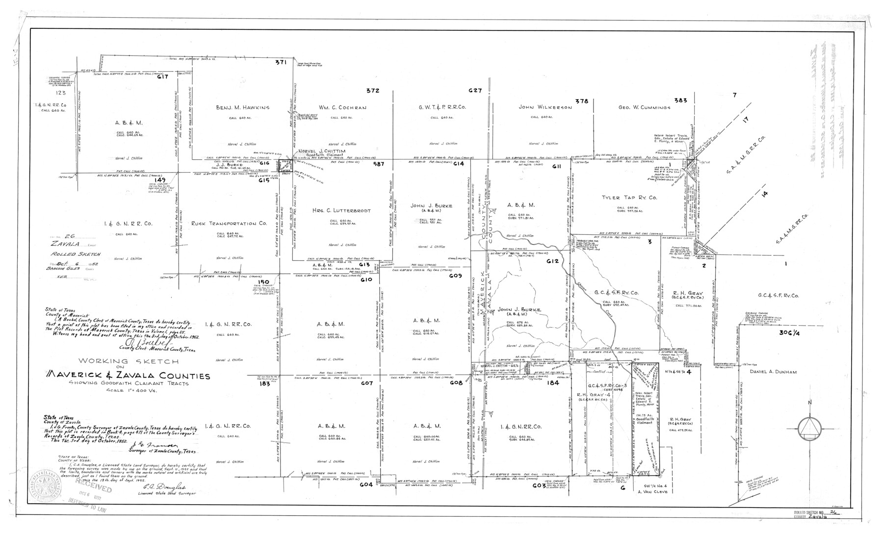
Zavala County Rolled Sketch 26
Working sketch on Maverick & Zavala Counties showing Good Faith Claimant tracts
-
Map/Doc
8328
-
Collection
General Map Collection
-
Object Dates
1952/9/13 (Creation Date)
1952/10/6 (File Date)
1952/9/11 (Survey Date)
-
People and Organizations
C.A. Douglas (Surveyor/Engineer)
-
Counties
Zavala Maverick
-
Subjects
Surveying Rolled Sketch
-
Height x Width
25.3 x 41.8 inches
64.3 x 106.2 cm
-
Medium
linen, manuscript
-
Scale
1" = 400 varas
Part of: General Map Collection

Refugio County Working Sketch 9

Print $20.00
- Digital $50.00
Refugio County Working Sketch 9
1941
Size 38.6 x 28.3 inches
Map/Doc 63518
Webb County Sketch File 58

Print $10.00
- Digital $50.00
Webb County Sketch File 58
1942
Size 14.4 x 8.9 inches
Map/Doc 39846
Visitor's Guide to the Aztec World

Visitor's Guide to the Aztec World
1980
Size 20.3 x 25.9 inches
Map/Doc 96833
Flight Mission No. DAG-17K, Frame 79, Matagorda County

Print $20.00
- Digital $50.00
Flight Mission No. DAG-17K, Frame 79, Matagorda County
1952
Size 19.7 x 25.0 inches
Map/Doc 86338
Hardin County Sketch File 49

Print $4.00
- Digital $50.00
Hardin County Sketch File 49
1904
Size 14.5 x 8.8 inches
Map/Doc 25202
Trinity River, Bulletin 30C/Richland Creek

Print $6.00
- Digital $50.00
Trinity River, Bulletin 30C/Richland Creek
1937
Size 11.7 x 31.8 inches
Map/Doc 65245
Lavaca County Working Sketch 2

Print $20.00
- Digital $50.00
Lavaca County Working Sketch 2
1904
Size 19.2 x 31.2 inches
Map/Doc 70355
Trinity River, Waxahachie Sheet/Waxahachie Creek

Print $6.00
- Digital $50.00
Trinity River, Waxahachie Sheet/Waxahachie Creek
1931
Size 30.1 x 32.8 inches
Map/Doc 65237
Lampasas County Rolled Sketch 1

Print $20.00
- Digital $50.00
Lampasas County Rolled Sketch 1
1975
Size 22.0 x 28.2 inches
Map/Doc 6564
Starr County Boundary File 99

Print $56.00
- Digital $50.00
Starr County Boundary File 99
Size 9.2 x 6.2 inches
Map/Doc 58846
[Sketch for Mineral Application 26546 - Sabine River between Hawkins Creek and east boundary line of BBB&C RR Co. Surveys, R. S. Rathke]
![65665, [Sketch for Mineral Application 26546 - Sabine River between Hawkins Creek and east boundary line of BBB&C RR Co. Surveys, R. S. Rathke], General Map Collection](https://historictexasmaps.com/wmedia_w700/maps/65665.tif.jpg)
Print $40.00
- Digital $50.00
[Sketch for Mineral Application 26546 - Sabine River between Hawkins Creek and east boundary line of BBB&C RR Co. Surveys, R. S. Rathke]
1931
Size 25.5 x 75.1 inches
Map/Doc 65665
You may also like
Victoria County Sketch File 9

Print $8.00
- Digital $50.00
Victoria County Sketch File 9
1938
Size 14.3 x 8.8 inches
Map/Doc 39530
Shelby County Sketch File 26

Print $4.00
- Digital $50.00
Shelby County Sketch File 26
Size 8.1 x 8.1 inches
Map/Doc 36660
Hutchinson County Rolled Sketch 38

Print $40.00
- Digital $50.00
Hutchinson County Rolled Sketch 38
1953
Size 27.5 x 85.9 inches
Map/Doc 10679
Kleberg County NRC Article 33.136 Location Key Sheet

Print $20.00
- Digital $50.00
Kleberg County NRC Article 33.136 Location Key Sheet
1975
Size 27.0 x 24.0 inches
Map/Doc 77051
Nueces County Rolled Sketch 61

Print $20.00
- Digital $50.00
Nueces County Rolled Sketch 61
1977
Size 32.2 x 39.3 inches
Map/Doc 6907
Intracoastal Waterway in Texas - Corpus Christi to Point Isabel including Arroyo Colorado to Mo. Pac. R.R. Bridge Near Harlingen

Print $20.00
- Digital $50.00
Intracoastal Waterway in Texas - Corpus Christi to Point Isabel including Arroyo Colorado to Mo. Pac. R.R. Bridge Near Harlingen
1934
Size 21.8 x 32.7 inches
Map/Doc 61885
Wise County Sketch File 18

Print $4.00
- Digital $50.00
Wise County Sketch File 18
1860
Size 12.8 x 7.8 inches
Map/Doc 40553
Upton County Working Sketch 17

Print $20.00
- Digital $50.00
Upton County Working Sketch 17
1941
Size 36.1 x 22.1 inches
Map/Doc 69513
Hudspeth County Working Sketch 46

Print $20.00
- Digital $50.00
Hudspeth County Working Sketch 46
1983
Size 47.0 x 43.0 inches
Map/Doc 66331
Frio County Working Sketch 18

Print $20.00
- Digital $50.00
Frio County Working Sketch 18
1982
Size 35.7 x 36.8 inches
Map/Doc 69292
Brady's Glimpses of Texas with maps

Print $216.00
- Digital $50.00
Brady's Glimpses of Texas with maps
1871
Size 7.5 x 4.9 inches
Map/Doc 93918
Red River, Bois D'Arc Creek Floodway Sheet No. 4

Print $20.00
- Digital $50.00
Red River, Bois D'Arc Creek Floodway Sheet No. 4
1917
Size 20.3 x 28.9 inches
Map/Doc 69659