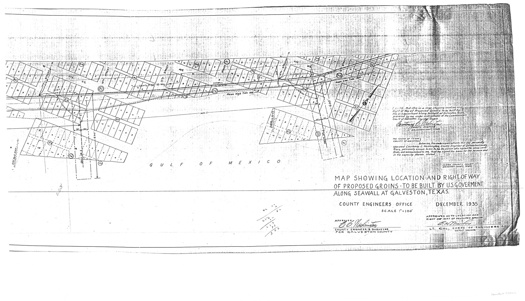
Map Showing Location and Right of Way of Proposed Groins - to be built by U.S. Government Along Seawall at Galveston, Texas
Galveston Miscellaneous 6
-
Map/Doc
73622
-
Collection
General Map Collection
-
Object Dates
12/1935 (Creation Date)
-
People and Organizations
County Engineers Office (Publisher)
-
Counties
Galveston
-
Subjects
City
-
Height x Width
20.8 x 36.3 inches
52.8 x 92.2 cm
-
Comments
Xerox copy
Part of: General Map Collection
Zavala County Sketch File 49

Print $10.00
- Digital $50.00
Zavala County Sketch File 49
1955
Size 14.5 x 9.1 inches
Map/Doc 41441
Liberty County Working Sketch Graphic Index - east part

Print $20.00
- Digital $50.00
Liberty County Working Sketch Graphic Index - east part
1977
Size 46.0 x 34.5 inches
Map/Doc 76620
Map of the Rio Grande & Eagle Pass Ry. from Sections 21-25 9/10 Inclusive, Webb County

Print $40.00
- Digital $50.00
Map of the Rio Grande & Eagle Pass Ry. from Sections 21-25 9/10 Inclusive, Webb County
1909
Size 25.8 x 55.4 inches
Map/Doc 64658
DeWitt County Working Sketch 16

Print $20.00
- Digital $50.00
DeWitt County Working Sketch 16
1920
Size 23.0 x 25.1 inches
Map/Doc 69016
Map exhibiting the lines of march passed over by the troops of the United States during the year ending June 30th, 1858 prepared by order of the Hon. J.B. Floyd, Sec. War.

Print $20.00
- Digital $50.00
Map exhibiting the lines of march passed over by the troops of the United States during the year ending June 30th, 1858 prepared by order of the Hon. J.B. Floyd, Sec. War.
1858
Size 20.0 x 20.3 inches
Map/Doc 94079
Nueces River, Bluntzer Sheet

Print $20.00
- Digital $50.00
Nueces River, Bluntzer Sheet
1927
Size 35.3 x 42.9 inches
Map/Doc 65088
Gregg County Working Sketch 7

Print $20.00
- Digital $50.00
Gregg County Working Sketch 7
1934
Size 32.2 x 21.0 inches
Map/Doc 63273
Navigation Maps of Gulf Intracoastal Waterway, Port Arthur to Brownsville, Texas

Print $4.00
- Digital $50.00
Navigation Maps of Gulf Intracoastal Waterway, Port Arthur to Brownsville, Texas
1951
Size 16.7 x 21.5 inches
Map/Doc 65439
Angelina County Rolled Sketch 2

Print $20.00
- Digital $50.00
Angelina County Rolled Sketch 2
1948
Size 21.9 x 20.1 inches
Map/Doc 77185
Dickens County Sketch File H1

Print $20.00
- Digital $50.00
Dickens County Sketch File H1
1902
Size 16.7 x 15.1 inches
Map/Doc 11336
Nueces County Working Sketch 10

Print $20.00
- Digital $50.00
Nueces County Working Sketch 10
1963
Size 26.7 x 27.7 inches
Map/Doc 71312
Padre Island National Seashore

Print $4.00
- Digital $50.00
Padre Island National Seashore
Size 16.1 x 22.4 inches
Map/Doc 60541
You may also like
Wise County Sketch File 33

Print $22.00
- Digital $50.00
Wise County Sketch File 33
Size 13.7 x 18.1 inches
Map/Doc 40590
Duval County Sketch File 8d

Print $4.00
- Digital $50.00
Duval County Sketch File 8d
1869
Size 10.8 x 8.9 inches
Map/Doc 21302
Sutton County Boundary File 1

Print $4.00
- Digital $50.00
Sutton County Boundary File 1
Size 14.5 x 8.9 inches
Map/Doc 59002
![4781, Coke Co[unty], General Map Collection](https://historictexasmaps.com/wmedia_w700/maps/4781.tif.jpg)
Map of Bastrop County

Print $20.00
- Digital $50.00
Map of Bastrop County
1861
Size 26.3 x 29.0 inches
Map/Doc 3280
St. L. S-W. Ry. of Texas Map of Hillsboro Branch in Navarro County, Texas M.P. 621 to M.P. 648

Print $40.00
- Digital $50.00
St. L. S-W. Ry. of Texas Map of Hillsboro Branch in Navarro County, Texas M.P. 621 to M.P. 648
1913
Size 28.0 x 431.2 inches
Map/Doc 94016
Flight Mission No. BRA-7M, Frame 188, Jefferson County

Print $20.00
- Digital $50.00
Flight Mission No. BRA-7M, Frame 188, Jefferson County
1953
Size 18.6 x 22.3 inches
Map/Doc 85556
In the Supreme Court of the United States The State of Oklahoma, Complainant vs. The State of Texas, Defendant, The United States of America, Intervener - 1920

Print $20.00
- Digital $50.00
In the Supreme Court of the United States The State of Oklahoma, Complainant vs. The State of Texas, Defendant, The United States of America, Intervener - 1920
1920
Size 32.4 x 36.8 inches
Map/Doc 75129
Jack County Sketch File 10a

Print $4.00
- Digital $50.00
Jack County Sketch File 10a
1858
Size 13.8 x 8.3 inches
Map/Doc 27529
Hood County Working Sketch 2

Print $20.00
- Digital $50.00
Hood County Working Sketch 2
1956
Size 20.5 x 25.5 inches
Map/Doc 66196
[Eastern Texas RR. Co. Block 1]
![91922, [Eastern Texas RR. Co. Block 1], Twichell Survey Records](https://historictexasmaps.com/wmedia_w700/maps/91922-1.tif.jpg)
Print $20.00
- Digital $50.00
[Eastern Texas RR. Co. Block 1]
Size 34.7 x 31.0 inches
Map/Doc 91922
Upshur County Working Sketch 15b

Print $20.00
- Digital $50.00
Upshur County Working Sketch 15b
1996
Size 36.7 x 29.4 inches
Map/Doc 69572