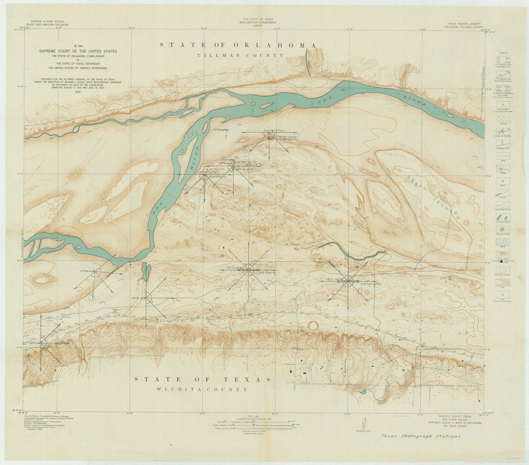
In the Supreme Court of the United States The State of Oklahoma, Complainant vs. The State of Texas, Defendant, The United States of America, Intervener - 1920
-
Map/Doc
75129
-
Collection
General Map Collection
-
Object Dates
1920 (Creation Date)
-
Subjects
Legal Texas Boundaries
-
Height x Width
32.4 x 36.8 inches
82.3 x 93.5 cm
Part of: General Map Collection
Lipscomb County Working Sketch 1

Print $20.00
- Digital $50.00
Lipscomb County Working Sketch 1
1964
Size 30.7 x 34.1 inches
Map/Doc 70577

Duval County Sketch File 4a

Print $6.00
- Digital $50.00
Duval County Sketch File 4a
1875
Size 13.3 x 10.8 inches
Map/Doc 21280
Flight Mission No. BRE-1P, Frame 103, Nueces County

Print $20.00
- Digital $50.00
Flight Mission No. BRE-1P, Frame 103, Nueces County
1956
Size 18.4 x 22.2 inches
Map/Doc 86674
Anderson County Rolled Sketch 8

Print $20.00
- Digital $50.00
Anderson County Rolled Sketch 8
Size 34.8 x 23.9 inches
Map/Doc 77154
Harris County Historic Topographic 15

Print $20.00
- Digital $50.00
Harris County Historic Topographic 15
1916
Size 29.2 x 22.9 inches
Map/Doc 65825
Webb County Sketch File A1

Print $20.00
- Digital $50.00
Webb County Sketch File A1
1897
Size 20.3 x 20.3 inches
Map/Doc 12604
No. 3 Chart of Channel connecting Corpus Christi Bay with Aransas Bay, Texas

Print $20.00
- Digital $50.00
No. 3 Chart of Channel connecting Corpus Christi Bay with Aransas Bay, Texas
1878
Size 18.3 x 27.5 inches
Map/Doc 72784
Wilbarger County Sketch File 1

Print $4.00
- Digital $50.00
Wilbarger County Sketch File 1
Size 8.2 x 12.8 inches
Map/Doc 40162
Kerr County Boundary File 1

Print $4.00
- Digital $50.00
Kerr County Boundary File 1
Size 12.7 x 8.1 inches
Map/Doc 55982
Crane County Sketch File 30

Print $40.00
- Digital $50.00
Crane County Sketch File 30
1933
Size 14.0 x 8.4 inches
Map/Doc 19610
Real County Working Sketch 73

Print $20.00
- Digital $50.00
Real County Working Sketch 73
1978
Size 28.2 x 24.9 inches
Map/Doc 71965
You may also like
Bastrop County Sketch File 9

Print $40.00
- Digital $50.00
Bastrop County Sketch File 9
1943
Size 46.5 x 20.6 inches
Map/Doc 10320
St Francis situated in Potter and Carson Counties, Texas

Print $20.00
- Digital $50.00
St Francis situated in Potter and Carson Counties, Texas
Size 22.9 x 27.7 inches
Map/Doc 93078
Mason County Working Sketch 15

Print $40.00
- Digital $50.00
Mason County Working Sketch 15
1976
Size 61.9 x 45.4 inches
Map/Doc 70851
Aransas County Working Sketch 18

Print $20.00
- Digital $50.00
Aransas County Working Sketch 18
1961
Size 36.0 x 30.7 inches
Map/Doc 67185
Calhoun County Sketch File 15

Print $40.00
- Digital $50.00
Calhoun County Sketch File 15
1929
Size 36.8 x 25.4 inches
Map/Doc 11036
Kent County Boundary File 9

Print $8.00
- Digital $50.00
Kent County Boundary File 9
Size 14.1 x 8.8 inches
Map/Doc 55883
Andrews County Working Sketch 22

Print $40.00
- Digital $50.00
Andrews County Working Sketch 22
1979
Size 38.3 x 48.8 inches
Map/Doc 67068
Brazos River Conservation and Reclamation District Official Boundary Line Survey

Print $20.00
- Digital $50.00
Brazos River Conservation and Reclamation District Official Boundary Line Survey
Size 36.6 x 24.6 inches
Map/Doc 90128
Lee County Rolled Sketch 3

Print $20.00
- Digital $50.00
Lee County Rolled Sketch 3
2010
Size 25.5 x 36.0 inches
Map/Doc 89288
Flight Mission No. CUG-2P, Frame 21, Kleberg County

Print $20.00
- Digital $50.00
Flight Mission No. CUG-2P, Frame 21, Kleberg County
1956
Size 18.5 x 22.3 inches
Map/Doc 86185
Brazoria County Sketch File 11

Print $4.00
- Digital $50.00
Brazoria County Sketch File 11
Size 10.5 x 8.5 inches
Map/Doc 14965
Nolan County Sketch File 13

Print $20.00
- Digital $50.00
Nolan County Sketch File 13
1886
Size 17.8 x 29.9 inches
Map/Doc 42207