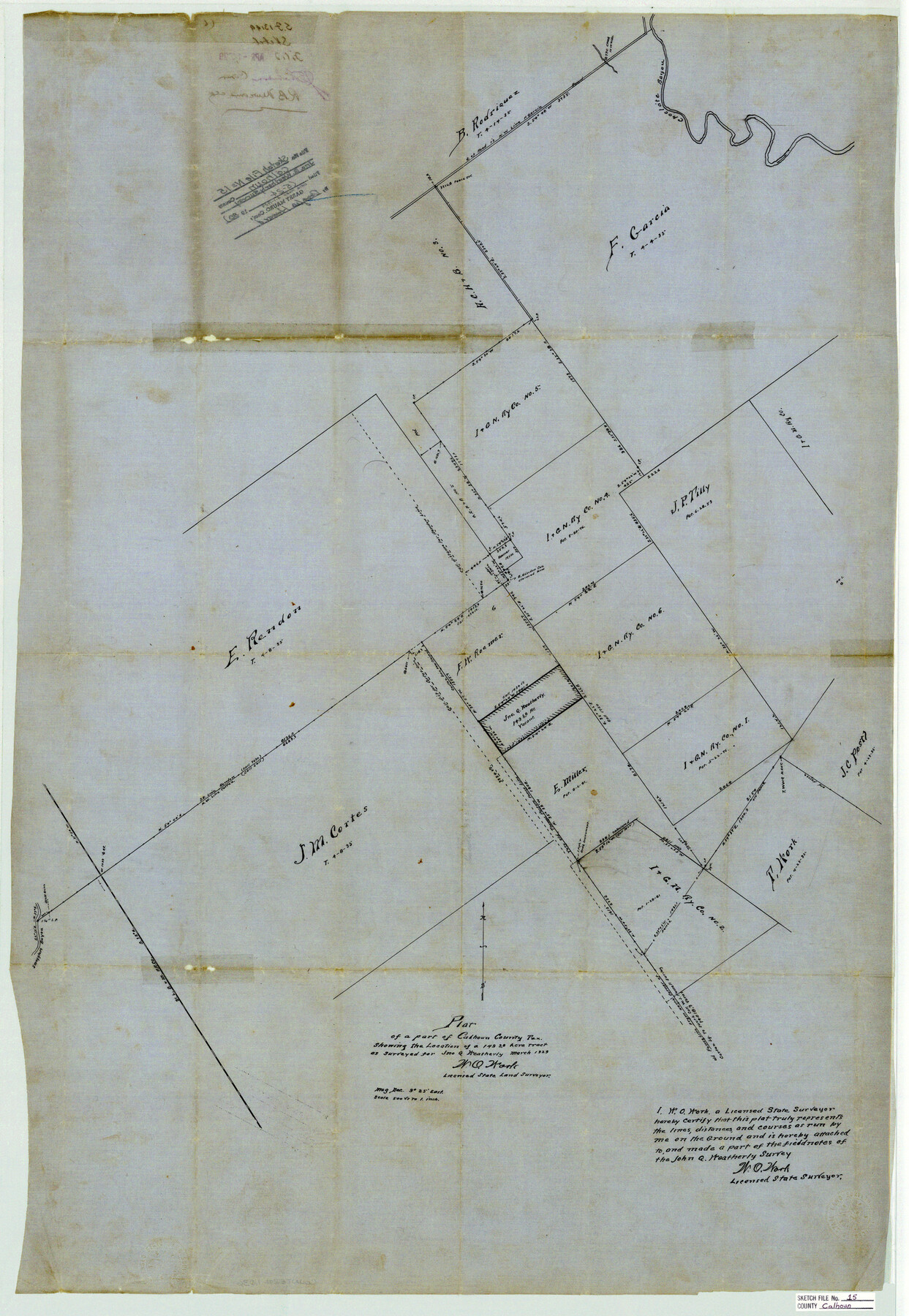
Calhoun County Sketch File 15
Plat of a part of Calhoun County, Tex. showing the location of a 149.28 acre tract as surveyed for Jno. G. Weatherly
-
Map/Doc
11036
-
Collection
General Map Collection
-
Object Dates
1929 (Creation Date)
1988/5/24 (File Date)
-
People and Organizations
W.O. Work (Surveyor/Engineer)
-
Counties
Calhoun
-
Subjects
Surveying Sketch File
-
Height x Width
36.8 x 25.4 inches
93.5 x 64.5 cm
-
Medium
paper, manuscript
-
Scale
1" = 500 varas
-
Features
Choclate [sic] Bayou
Smugglers Bayou
Part of: General Map Collection
Williamson County Boundary File 3

Print $20.00
- Digital $50.00
Williamson County Boundary File 3
Size 18.5 x 23.6 inches
Map/Doc 60012
Brazoria County NRC Article 33.136 Sketch 15

Print $44.00
- Digital $50.00
Brazoria County NRC Article 33.136 Sketch 15
2014
Size 39.8 x 30.0 inches
Map/Doc 94698
Flight Mission No. CGI-4N, Frame 23, Cameron County

Print $20.00
- Digital $50.00
Flight Mission No. CGI-4N, Frame 23, Cameron County
1954
Size 18.6 x 22.4 inches
Map/Doc 84656
Hudspeth County Working Sketch 5

Print $20.00
- Digital $50.00
Hudspeth County Working Sketch 5
1921
Size 27.8 x 38.8 inches
Map/Doc 66286
King County Working Sketch 17

Print $40.00
- Digital $50.00
King County Working Sketch 17
1979
Size 32.2 x 59.3 inches
Map/Doc 70181
Webb County Rolled Sketch 49

Print $40.00
- Digital $50.00
Webb County Rolled Sketch 49
1943
Size 55.4 x 13.1 inches
Map/Doc 10124
Comal County Working Sketch 6

Print $20.00
- Digital $50.00
Comal County Working Sketch 6
1950
Size 25.1 x 24.2 inches
Map/Doc 68172
Kent County Working Sketch 22

Print $20.00
- Digital $50.00
Kent County Working Sketch 22
1987
Size 42.7 x 43.1 inches
Map/Doc 70029
Real County Working Sketch 50

Print $20.00
- Digital $50.00
Real County Working Sketch 50
1957
Size 19.8 x 26.1 inches
Map/Doc 71942
Goliad County Sketch File 28

Print $20.00
- Digital $50.00
Goliad County Sketch File 28
Size 18.9 x 15.5 inches
Map/Doc 11569
Webb County Working Sketch 47

Print $20.00
- Digital $50.00
Webb County Working Sketch 47
1948
Size 35.9 x 36.2 inches
Map/Doc 72412
Young County Rolled Sketch 11

Print $20.00
- Digital $50.00
Young County Rolled Sketch 11
Size 14.9 x 23.1 inches
Map/Doc 8299
You may also like
General Highway Map, Atascosa County, Texas

Print $20.00
General Highway Map, Atascosa County, Texas
1961
Size 18.3 x 25.0 inches
Map/Doc 79355
Hays County Sketch File 13 and 14

Print $8.00
- Digital $50.00
Hays County Sketch File 13 and 14
1868
Size 12.4 x 8.0 inches
Map/Doc 26220

Flight Mission No. BRA-6M, Frame 85, Jefferson County

Print $20.00
- Digital $50.00
Flight Mission No. BRA-6M, Frame 85, Jefferson County
1953
Size 18.6 x 22.4 inches
Map/Doc 85429
Guadalupe County Working Sketch 10

Print $20.00
- Digital $50.00
Guadalupe County Working Sketch 10
1966
Size 21.2 x 27.2 inches
Map/Doc 63319
Dallas County Sketch File 19 1/2

Print $4.00
- Digital $50.00
Dallas County Sketch File 19 1/2
Size 9.9 x 8.2 inches
Map/Doc 20439
Reeves County Rolled Sketch 31

Print $20.00
- Digital $50.00
Reeves County Rolled Sketch 31
Size 21.7 x 27.9 inches
Map/Doc 7500
Fisher County Sketch File 23

Print $12.00
- Digital $50.00
Fisher County Sketch File 23
1875
Size 10.8 x 8.2 inches
Map/Doc 22660
Notes for map of Montgomery County

Print $20.00
- Digital $50.00
Notes for map of Montgomery County
1844
Size 17.6 x 21.9 inches
Map/Doc 78370
[Sketch for Mineral Application 16696-16697, Pecos River]
![65612, [Sketch for Mineral Application 16696-16697, Pecos River], General Map Collection](https://historictexasmaps.com/wmedia_w700/maps/65612-1.tif.jpg)
Print $40.00
- Digital $50.00
[Sketch for Mineral Application 16696-16697, Pecos River]
Size 37.4 x 74.9 inches
Map/Doc 65612
Dallas County Sketch File 21

Print $22.00
- Digital $50.00
Dallas County Sketch File 21
1888
Size 14.2 x 8.9 inches
Map/Doc 20443
