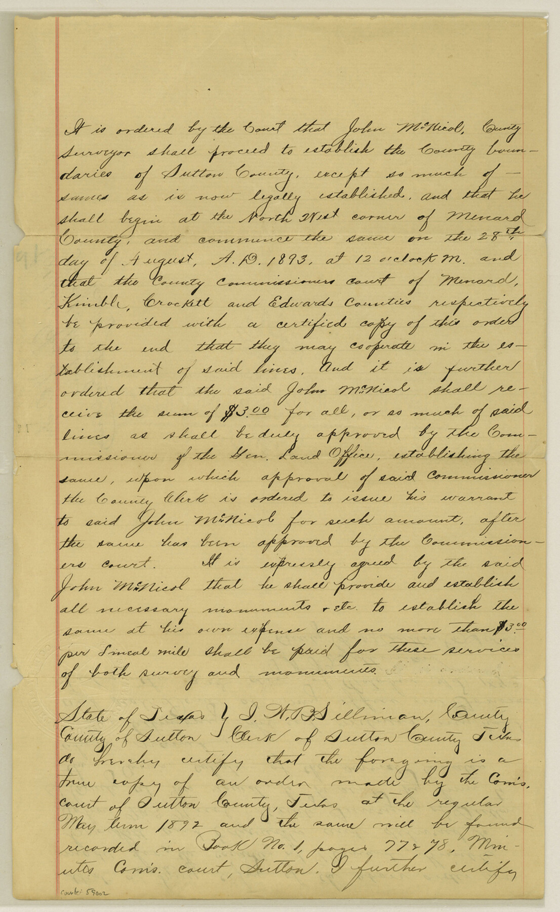
Sutton County Boundary File 1
Certified Copy of Order for Establishing County Boundaries
-
Map/Doc
59002
-
Collection
General Map Collection
-
Counties
Sutton
-
Subjects
County Boundaries
-
Height x Width
14.5 x 8.9 inches
36.8 x 22.6 cm
Part of: General Map Collection
Map of Erath County

Print $40.00
- Digital $50.00
Map of Erath County
1896
Size 49.6 x 43.5 inches
Map/Doc 4943
[Subdivision of Nueces Bay and list of Court Decrees]
![2086, [Subdivision of Nueces Bay and list of Court Decrees], General Map Collection](https://historictexasmaps.com/wmedia_w700/maps/2086-1.tif.jpg)
Print $40.00
- Digital $50.00
[Subdivision of Nueces Bay and list of Court Decrees]
1940
Size 34.2 x 48.8 inches
Map/Doc 2086
San Bernard River, Texas showing possible connection with Brazos River and part of possible connection with Matagorda Bay for a Light Draft Navigation

Print $40.00
- Digital $50.00
San Bernard River, Texas showing possible connection with Brazos River and part of possible connection with Matagorda Bay for a Light Draft Navigation
Size 17.2 x 56.1 inches
Map/Doc 96561
Kent County Sketch File A

Print $4.00
- Digital $50.00
Kent County Sketch File A
Size 8.2 x 9.0 inches
Map/Doc 28821
Cass County Working Sketch 29

Print $20.00
- Digital $50.00
Cass County Working Sketch 29
1979
Size 38.4 x 23.5 inches
Map/Doc 67932
Cooke County Sketch File 42

Print $8.00
- Digital $50.00
Cooke County Sketch File 42
1940
Size 14.3 x 8.8 inches
Map/Doc 19316
Map of Texas and the countries adjacent compiled in the Bureau of the Corps of Topographical Engineers from the best authorities for the State Department

Print $20.00
- Digital $50.00
Map of Texas and the countries adjacent compiled in the Bureau of the Corps of Topographical Engineers from the best authorities for the State Department
1844
Size 25.9 x 18.2 inches
Map/Doc 72714
Jackson County Working Sketch 14

Print $20.00
- Digital $50.00
Jackson County Working Sketch 14
1990
Size 31.7 x 32.2 inches
Map/Doc 66462
[Surveys along the Salado and Lampasas Rivers and Saltillo Creek]
![362, [Surveys along the Salado and Lampasas Rivers and Saltillo Creek], General Map Collection](https://historictexasmaps.com/wmedia_w700/maps/362.tif.jpg)
Print $2.00
- Digital $50.00
[Surveys along the Salado and Lampasas Rivers and Saltillo Creek]
1845
Size 13.1 x 7.8 inches
Map/Doc 362
A Geographically Correct Map of the State of Texas

Print $20.00
- Digital $50.00
A Geographically Correct Map of the State of Texas
1876
Size 20.0 x 21.5 inches
Map/Doc 93397
Jeff Davis County Working Sketch 6

Print $20.00
- Digital $50.00
Jeff Davis County Working Sketch 6
1928
Size 43.5 x 39.8 inches
Map/Doc 66501
Map of a part of Laguna Madre in Willacy & Cameron Counties showing subdivision for mineral development

Print $20.00
- Digital $50.00
Map of a part of Laguna Madre in Willacy & Cameron Counties showing subdivision for mineral development
1950
Size 46.9 x 37.0 inches
Map/Doc 3097
You may also like
Flight Mission No. DCL-6C, Frame 68, Kenedy County

Print $20.00
- Digital $50.00
Flight Mission No. DCL-6C, Frame 68, Kenedy County
1943
Size 18.6 x 22.4 inches
Map/Doc 85910
A Map of the United States of Mexico as organized and defined by the several Acts of the Congress of that Republic

Print $20.00
- Digital $50.00
A Map of the United States of Mexico as organized and defined by the several Acts of the Congress of that Republic
1826
Size 23.9 x 31.2 inches
Map/Doc 93939
General Highway Map, Grayson County, Texas

Print $20.00
General Highway Map, Grayson County, Texas
1940
Size 24.9 x 18.4 inches
Map/Doc 79104
Capitol Complex, Austin, Texas

Print $20.00
- Digital $50.00
Capitol Complex, Austin, Texas
1974
Size 42.7 x 30.6 inches
Map/Doc 94241
Shelby County Sketch File 7

Print $4.00
- Digital $50.00
Shelby County Sketch File 7
1855
Size 8.9 x 13.3 inches
Map/Doc 36605
La Salle County Sketch File 8

Print $20.00
- Digital $50.00
La Salle County Sketch File 8
Size 27.2 x 19.3 inches
Map/Doc 11979
Culberson County Rolled Sketch 18

Print $6.00
- Digital $50.00
Culberson County Rolled Sketch 18
1911
Size 24.1 x 34.5 inches
Map/Doc 5650
Map of Cameron County

Print $40.00
- Digital $50.00
Map of Cameron County
1895
Size 48.9 x 28.9 inches
Map/Doc 4901
Brazoria County NRC Article 33.136 Sketch 24

Print $24.00
Brazoria County NRC Article 33.136 Sketch 24
2025
Map/Doc 97504
Freestone County Sketch File 25

Print $18.00
- Digital $50.00
Freestone County Sketch File 25
1952
Size 11.3 x 8.6 inches
Map/Doc 23087
Leon County Sketch File 5a

Print $4.00
- Digital $50.00
Leon County Sketch File 5a
1861
Size 13.1 x 8.5 inches
Map/Doc 29717
Stonewall County Rolled Sketch 21

Print $40.00
- Digital $50.00
Stonewall County Rolled Sketch 21
1953
Size 50.8 x 47.9 inches
Map/Doc 9960