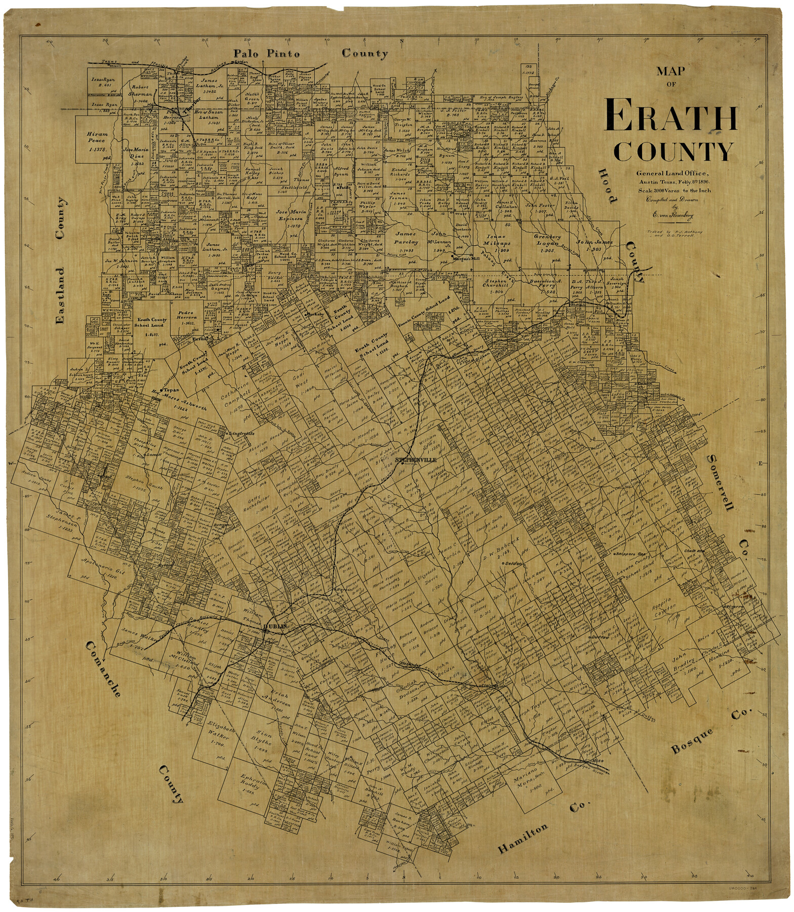
Map of Erath County
-
Map/Doc
4943
-
Collection
General Map Collection
-
Object Dates
2/8/1896 (Creation Date)
-
People and Organizations
Texas General Land Office (Publisher)
E. von Rosenberg (Draftsman)
E. von Rosenberg (Compiler)
-
Counties
Erath
-
Subjects
County
-
Height x Width
49.6 x 43.5 inches
126.0 x 110.5 cm
-
Comments
Traced by P. J. Anthony and O. O. Terrell.
Part of: General Map Collection
Nacogdoches County Sketch File 10

Print $6.00
- Digital $50.00
Nacogdoches County Sketch File 10
1886
Size 12.9 x 11.0 inches
Map/Doc 32253
Sterling County Sketch File 22

Print $4.00
- Digital $50.00
Sterling County Sketch File 22
1954
Size 11.2 x 8.7 inches
Map/Doc 37182
Bee County Sketch File 4

Print $6.00
- Digital $50.00
Bee County Sketch File 4
1858
Size 16.7 x 10.0 inches
Map/Doc 14268
Chambers County Sketch File 24

Print $20.00
- Digital $50.00
Chambers County Sketch File 24
1909
Size 34.1 x 14.5 inches
Map/Doc 11065
Hamilton County Boundary File 3

Print $52.00
- Digital $50.00
Hamilton County Boundary File 3
Size 14.2 x 8.8 inches
Map/Doc 54197
Flight Mission No. BRA-7M, Frame 19, Jefferson County

Print $20.00
- Digital $50.00
Flight Mission No. BRA-7M, Frame 19, Jefferson County
1953
Size 18.8 x 22.4 inches
Map/Doc 85470
Hudspeth County Working Sketch 44

Print $20.00
- Digital $50.00
Hudspeth County Working Sketch 44
1982
Size 25.5 x 22.2 inches
Map/Doc 66329
Flight Mission No. DQO-7K, Frame 80, Galveston County

Print $20.00
- Digital $50.00
Flight Mission No. DQO-7K, Frame 80, Galveston County
1952
Size 18.8 x 22.4 inches
Map/Doc 85107
Mason County Sketch File 13

Print $4.00
- Digital $50.00
Mason County Sketch File 13
Size 7.3 x 6.2 inches
Map/Doc 30701
Webb County Working Sketch 34

Print $20.00
- Digital $50.00
Webb County Working Sketch 34
1938
Size 23.8 x 24.3 inches
Map/Doc 72399
Flight Mission No. DQO-1K, Frame 115, Galveston County

Print $20.00
- Digital $50.00
Flight Mission No. DQO-1K, Frame 115, Galveston County
1952
Size 18.9 x 22.5 inches
Map/Doc 84993
El Paso County Rolled Sketch 2

Print $40.00
- Digital $50.00
El Paso County Rolled Sketch 2
Size 42.8 x 124.4 inches
Map/Doc 76433
You may also like
Louisiana and Texas Intracoastal Waterway - Matagorda Bay to San Antonio Bay Dredging - Sheet 1

Print $20.00
- Digital $50.00
Louisiana and Texas Intracoastal Waterway - Matagorda Bay to San Antonio Bay Dredging - Sheet 1
1938
Size 31.1 x 41.3 inches
Map/Doc 61814
Goliad County Sketch File 6

Print $2.00
- Digital $50.00
Goliad County Sketch File 6
1857
Size 8.8 x 4.9 inches
Map/Doc 24220
The Republic County of Bowie. January 28, 1841

Print $20.00
The Republic County of Bowie. January 28, 1841
2020
Size 19.5 x 21.7 inches
Map/Doc 96103
United States - Gulf Coast - From Latitude 26° 33' to the Rio Grande Texas

Print $20.00
- Digital $50.00
United States - Gulf Coast - From Latitude 26° 33' to the Rio Grande Texas
1918
Size 27.7 x 18.2 inches
Map/Doc 72850
Ward County Rolled Sketch 26

Print $28.00
- Digital $50.00
Ward County Rolled Sketch 26
Size 9.9 x 15.0 inches
Map/Doc 49468
[B. S. & F. Blk. M10, D. & S. E. RR. Co. Secs. 138 thru 149]
![90133, [B. S. & F. Blk. M10, D. & S. E. RR. Co. Secs. 138 thru 149], Twichell Survey Records](https://historictexasmaps.com/wmedia_w700/maps/90133-1.tif.jpg)
Print $20.00
- Digital $50.00
[B. S. & F. Blk. M10, D. & S. E. RR. Co. Secs. 138 thru 149]
Size 26.4 x 15.5 inches
Map/Doc 90133
Brewster County Working Sketch 57

Print $20.00
- Digital $50.00
Brewster County Working Sketch 57
1954
Size 19.6 x 20.8 inches
Map/Doc 67658
Armstrong County Working Sketch 5

Print $40.00
- Digital $50.00
Armstrong County Working Sketch 5
1918
Size 48.4 x 41.9 inches
Map/Doc 67236
Midland County Working Sketch 31

Print $20.00
- Digital $50.00
Midland County Working Sketch 31
1971
Size 44.8 x 30.9 inches
Map/Doc 71012
Flight Mission No. CUG-2P, Frame 69, Kleberg County

Print $20.00
- Digital $50.00
Flight Mission No. CUG-2P, Frame 69, Kleberg County
1956
Size 18.4 x 22.2 inches
Map/Doc 86206
Tarrant County Sketch File 24

Print $6.00
- Digital $50.00
Tarrant County Sketch File 24
Size 15.3 x 10.0 inches
Map/Doc 37735
Flight Mission No. DQO-7K, Frame 85, Galveston County

Print $20.00
- Digital $50.00
Flight Mission No. DQO-7K, Frame 85, Galveston County
1952
Size 18.9 x 22.5 inches
Map/Doc 85112