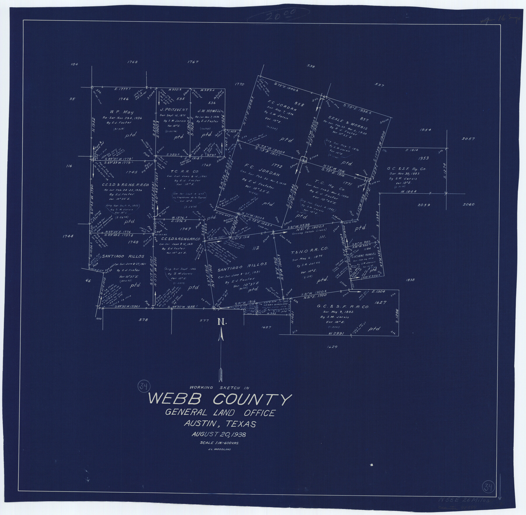
Webb County Working Sketch 34
-
Map/Doc
72399
-
Collection
General Map Collection
-
Object Dates
8/20/1938 (Creation Date)
-
People and Organizations
J.L. Woodland (Draftsman)
-
Counties
Webb
-
Subjects
Surveying Working Sketch
-
Height x Width
23.8 x 24.3 inches
60.5 x 61.7 cm
-
Scale
1" = 600 varas
Part of: General Map Collection
Hopkins County Sketch File 29

Print $4.00
- Digital $50.00
Hopkins County Sketch File 29
1873
Size 10.0 x 8.1 inches
Map/Doc 26740
Kinney County Rolled Sketch O

Print $20.00
- Digital $50.00
Kinney County Rolled Sketch O
1848
Size 32.1 x 36.2 inches
Map/Doc 6547
Bosque County Sketch File 15

Print $14.00
- Digital $50.00
Bosque County Sketch File 15
1863
Size 12.3 x 7.7 inches
Map/Doc 14774
Cooke County Rolled Sketch 3

Print $20.00
- Digital $50.00
Cooke County Rolled Sketch 3
1944
Size 37.1 x 40.2 inches
Map/Doc 8670
Clay County Rolled Sketch 5

Print $20.00
- Digital $50.00
Clay County Rolled Sketch 5
Size 21.0 x 23.6 inches
Map/Doc 5499
Flight Mission No. BRA-16M, Frame 101, Jefferson County

Print $20.00
- Digital $50.00
Flight Mission No. BRA-16M, Frame 101, Jefferson County
1953
Size 18.6 x 22.4 inches
Map/Doc 85713
Clay County Boundary File 19

Print $8.00
- Digital $50.00
Clay County Boundary File 19
1924
Size 3.3 x 5.5 inches
Map/Doc 65511
Terry County Rolled Sketch 5

Print $40.00
- Digital $50.00
Terry County Rolled Sketch 5
Size 56.8 x 38.1 inches
Map/Doc 9995
Hudspeth County Working Sketch 23

Print $40.00
- Digital $50.00
Hudspeth County Working Sketch 23
1967
Size 52.7 x 34.3 inches
Map/Doc 69650
Flight Mission No. BRE-2P, Frame 97, Nueces County

Print $20.00
- Digital $50.00
Flight Mission No. BRE-2P, Frame 97, Nueces County
1956
Size 18.5 x 22.3 inches
Map/Doc 86782
Denton County Sketch File 33a

Print $4.00
- Digital $50.00
Denton County Sketch File 33a
Size 8.0 x 13.1 inches
Map/Doc 20762
Brewster County Sketch File N-20

Print $40.00
- Digital $50.00
Brewster County Sketch File N-20
1941
Size 16.5 x 20.5 inches
Map/Doc 10967
You may also like
Travis County Boundary File 30

Print $4.00
- Digital $50.00
Travis County Boundary File 30
Size 10.4 x 8.6 inches
Map/Doc 59469
[Surveying Test and Answer Key]
![76001, [Surveying Test and Answer Key], General Map Collection](https://historictexasmaps.com/wmedia_w700/maps/76001.tif.jpg)
Print $20.00
- Digital $50.00
[Surveying Test and Answer Key]
Size 17.5 x 19.9 inches
Map/Doc 76001

Pecos County Rolled Sketch 146A

Print $37.00
- Digital $50.00
Pecos County Rolled Sketch 146A
1957
Size 10.4 x 15.2 inches
Map/Doc 48396
Map of La Salle County

Print $20.00
- Digital $50.00
Map of La Salle County
1877
Size 29.8 x 21.1 inches
Map/Doc 3797
Coryell County Rolled Sketch 2

Print $20.00
- Digital $50.00
Coryell County Rolled Sketch 2
1951
Size 15.7 x 19.1 inches
Map/Doc 5566
Dawson County Rolled Sketch 7

Print $20.00
- Digital $50.00
Dawson County Rolled Sketch 7
Size 18.5 x 39.3 inches
Map/Doc 5692
Plano de la Villa y Presidio de S. Antonio de Vejar situado en la Provincia de Tejas en 29 grad. y 52 minutos de latitud bor. y 275° y 57' de long. contados desde de Meridiano d. Tenerife

Plano de la Villa y Presidio de S. Antonio de Vejar situado en la Provincia de Tejas en 29 grad. y 52 minutos de latitud bor. y 275° y 57' de long. contados desde de Meridiano d. Tenerife
1768
Size 16.8 x 21.2 inches
Map/Doc 96564
Young County Boundary File 98a

Print $32.00
- Digital $50.00
Young County Boundary File 98a
Size 10.2 x 8.0 inches
Map/Doc 60211
Bowie County Working Sketch 26

Print $20.00
- Digital $50.00
Bowie County Working Sketch 26
1980
Size 29.1 x 24.7 inches
Map/Doc 67430
Harris County Working Sketch 7

Print $20.00
- Digital $50.00
Harris County Working Sketch 7
1900
Size 34.2 x 28.6 inches
Map/Doc 65899
Liberty County Working Sketch 71

Print $20.00
- Digital $50.00
Liberty County Working Sketch 71
1977
Size 37.3 x 31.8 inches
Map/Doc 70531