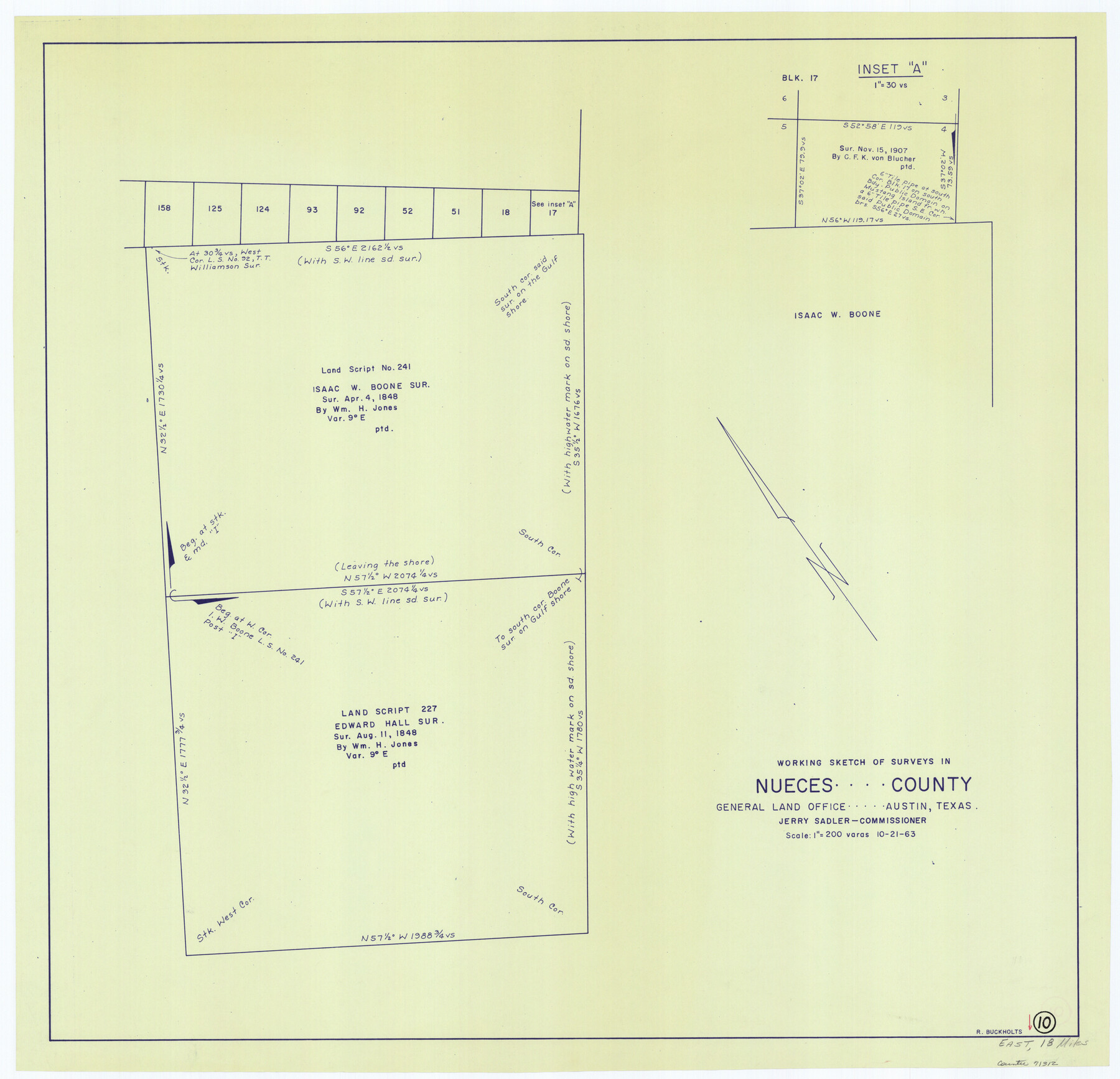
Nueces County Working Sketch 10
-
Map/Doc
71312
-
Collection
General Map Collection
-
Object Dates
10/21/1963 (Creation Date)
-
People and Organizations
Roy Buckholts (Draftsman)
-
Counties
Nueces
-
Subjects
Surveying Working Sketch
-
Height x Width
26.7 x 27.7 inches
67.8 x 70.4 cm
-
Scale
1" = 200 varas
Part of: General Map Collection
Presidio County Working Sketch 55

Print $20.00
- Digital $50.00
Presidio County Working Sketch 55
1955
Size 22.0 x 16.9 inches
Map/Doc 71732
Runnels County Working Sketch 14

Print $20.00
- Digital $50.00
Runnels County Working Sketch 14
1950
Size 28.4 x 26.8 inches
Map/Doc 63610
Burleson County Working Sketch 42

Print $20.00
- Digital $50.00
Burleson County Working Sketch 42
1953
Size 41.6 x 33.6 inches
Map/Doc 67761
Scurry County Rolled Sketch 1

Print $40.00
- Digital $50.00
Scurry County Rolled Sketch 1
Size 70.5 x 44.9 inches
Map/Doc 9910
Travis County Sketch File 69A

Print $20.00
- Digital $50.00
Travis County Sketch File 69A
Size 18.0 x 20.9 inches
Map/Doc 12476
Clay County Sketch File 12

Print $4.00
- Digital $50.00
Clay County Sketch File 12
1873
Size 13.0 x 8.2 inches
Map/Doc 18411
Denton County Boundary File 1a

Print $24.00
- Digital $50.00
Denton County Boundary File 1a
Size 12.4 x 8.1 inches
Map/Doc 52401
Map of Ferguson State Farm, Madison County, Texas

Print $20.00
- Digital $50.00
Map of Ferguson State Farm, Madison County, Texas
Size 21.6 x 26.1 inches
Map/Doc 62989
Presidio County Sketch File H

Print $4.00
- Digital $50.00
Presidio County Sketch File H
Size 5.8 x 9.6 inches
Map/Doc 34431
Limestone County Working Sketch 24

Print $20.00
- Digital $50.00
Limestone County Working Sketch 24
1980
Size 28.9 x 31.6 inches
Map/Doc 70574
Palo Pinto County

Print $20.00
- Digital $50.00
Palo Pinto County
1941
Size 44.9 x 35.9 inches
Map/Doc 77389
Menard County Working Sketch 9

Print $20.00
- Digital $50.00
Menard County Working Sketch 9
1937
Size 22.9 x 22.5 inches
Map/Doc 70956
You may also like
Flight Mission No. CRC-4R, Frame 76, Chambers County

Print $20.00
- Digital $50.00
Flight Mission No. CRC-4R, Frame 76, Chambers County
1956
Size 18.8 x 22.4 inches
Map/Doc 84880
Map of Ramsey State Farm

Print $20.00
- Digital $50.00
Map of Ramsey State Farm
1934
Size 30.3 x 38.0 inches
Map/Doc 94284
Rains County Rolled Sketch 1

Print $40.00
- Digital $50.00
Rains County Rolled Sketch 1
1958
Size 42.0 x 65.2 inches
Map/Doc 9806
Hardeman County Sketch File A2

Print $20.00
- Digital $50.00
Hardeman County Sketch File A2
Size 28.5 x 17.3 inches
Map/Doc 11631
Eastland County Working Sketch 54

Print $20.00
- Digital $50.00
Eastland County Working Sketch 54
1984
Size 19.6 x 18.0 inches
Map/Doc 68835
Soash-White Industrial Properties

Print $20.00
- Digital $50.00
Soash-White Industrial Properties
Size 37.4 x 24.9 inches
Map/Doc 92776
Flight Mission No. CRK-8P, Frame 100, Refugio County

Print $20.00
- Digital $50.00
Flight Mission No. CRK-8P, Frame 100, Refugio County
1956
Size 18.2 x 22.0 inches
Map/Doc 86961
Crockett County Rolled Sketch 27A

Print $40.00
- Digital $50.00
Crockett County Rolled Sketch 27A
1925
Size 22.3 x 59.5 inches
Map/Doc 8692
Chambers County Working Sketch 8

Print $20.00
- Digital $50.00
Chambers County Working Sketch 8
1940
Size 20.9 x 44.4 inches
Map/Doc 67991
Hemphill County Working Sketch 37

Print $20.00
- Digital $50.00
Hemphill County Working Sketch 37
1981
Size 28.6 x 24.0 inches
Map/Doc 66132
Hockley County

Print $20.00
- Digital $50.00
Hockley County
1914
Size 22.3 x 25.9 inches
Map/Doc 92244
Lee County Working Sketch 4

Print $20.00
- Digital $50.00
Lee County Working Sketch 4
1973
Size 17.1 x 18.4 inches
Map/Doc 70383