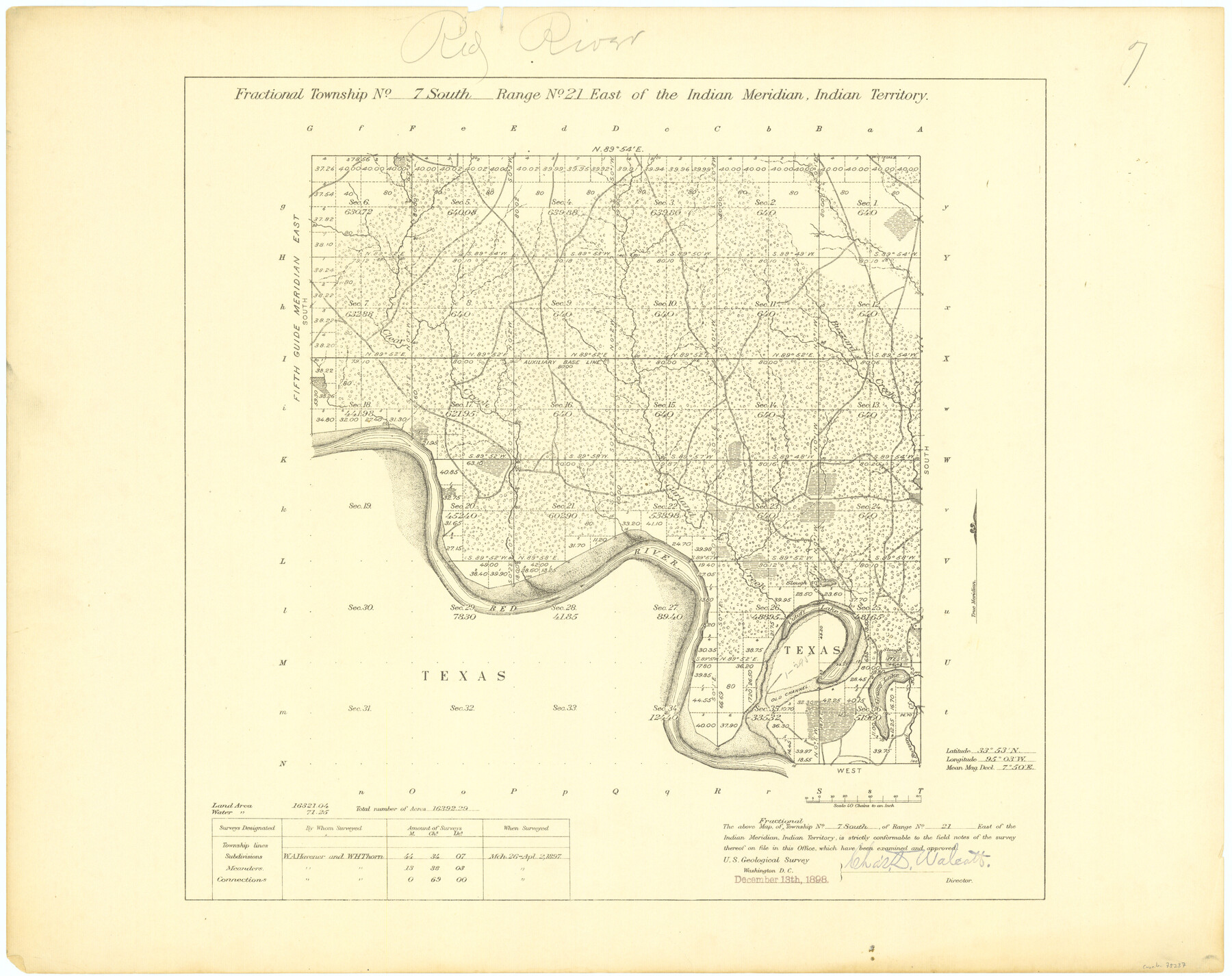
Fractional Township No. 7 South Range No. 21 East of the Indian Meridian, Indian Territory
-
Map/Doc
75237
-
Collection
General Map Collection
-
Object Dates
1897/4/2 (Creation Date)
-
Subjects
Texas Boundaries
-
Height x Width
19.2 x 24.2 inches
48.8 x 61.5 cm
Part of: General Map Collection
Culberson County Working Sketch 37

Print $20.00
- Digital $50.00
Culberson County Working Sketch 37
1966
Size 22.4 x 40.5 inches
Map/Doc 68490
Sterling County Rolled Sketch 34

Print $20.00
- Digital $50.00
Sterling County Rolled Sketch 34
1960
Size 16.0 x 21.8 inches
Map/Doc 7858
Bee County Sketch File 8b

Print $4.00
- Digital $50.00
Bee County Sketch File 8b
Size 11.5 x 8.1 inches
Map/Doc 14287
Matagorda County Rolled Sketch 15

Print $20.00
- Digital $50.00
Matagorda County Rolled Sketch 15
Size 24.5 x 14.9 inches
Map/Doc 6682
Presidio County Sketch File 116A

Print $63.00
- Digital $50.00
Presidio County Sketch File 116A
Size 17.0 x 11.0 inches
Map/Doc 34885
Mills County Sketch File 18

Print $4.00
- Digital $50.00
Mills County Sketch File 18
1872
Size 12.1 x 8.1 inches
Map/Doc 31668
Eastland County Working Sketch 14

Print $20.00
- Digital $50.00
Eastland County Working Sketch 14
1919
Size 18.2 x 17.1 inches
Map/Doc 68795

Jasper County Sketch File 34

Print $4.00
- Digital $50.00
Jasper County Sketch File 34
1873
Size 12.4 x 8.1 inches
Map/Doc 27868
Flight Mission No. CRK-7P, Frame 27, Refugio County

Print $20.00
- Digital $50.00
Flight Mission No. CRK-7P, Frame 27, Refugio County
1956
Size 18.3 x 22.1 inches
Map/Doc 86947
Crockett County Rolled Sketch 26

Print $20.00
- Digital $50.00
Crockett County Rolled Sketch 26
Size 33.7 x 40.9 inches
Map/Doc 5585
Jeff Davis County Rolled Sketch 26

Print $20.00
- Digital $50.00
Jeff Davis County Rolled Sketch 26
1957
Size 25.1 x 42.3 inches
Map/Doc 6374
You may also like
Sketch showing Damon's Mound and adjacent surveys

Print $20.00
- Digital $50.00
Sketch showing Damon's Mound and adjacent surveys
Size 19.4 x 17.7 inches
Map/Doc 90218
Briscoe County Working Sketch 5

Print $20.00
- Digital $50.00
Briscoe County Working Sketch 5
1934
Size 36.7 x 43.0 inches
Map/Doc 67808
McCulloch County Working Sketch 13

Print $20.00
- Digital $50.00
McCulloch County Working Sketch 13
1989
Size 36.7 x 33.3 inches
Map/Doc 70688
Hale County Rolled Sketch 5

Print $20.00
- Digital $50.00
Hale County Rolled Sketch 5
1893
Size 29.0 x 22.2 inches
Map/Doc 9094
Webb County Working Sketch 71

Print $40.00
- Digital $50.00
Webb County Working Sketch 71
1973
Size 46.1 x 95.8 inches
Map/Doc 72438
Nacogdoches County Sketch File 3

Print $8.00
- Digital $50.00
Nacogdoches County Sketch File 3
Size 6.5 x 8.2 inches
Map/Doc 32237
San Patricio County Rolled Sketch 30 & 30A

Print $20.00
- Digital $50.00
San Patricio County Rolled Sketch 30 & 30A
1941
Size 47.1 x 27.9 inches
Map/Doc 9896
Flight Mission No. DIX-10P, Frame 145, Aransas County

Print $20.00
- Digital $50.00
Flight Mission No. DIX-10P, Frame 145, Aransas County
1956
Size 18.7 x 22.3 inches
Map/Doc 83947
Shelby County Rolled Sketch 5

Print $20.00
- Digital $50.00
Shelby County Rolled Sketch 5
1942
Size 37.9 x 43.7 inches
Map/Doc 9921
Galveston County NRC Article 33.136 Location Key Sheet

Print $20.00
- Digital $50.00
Galveston County NRC Article 33.136 Location Key Sheet
1994
Size 27.0 x 23.0 inches
Map/Doc 77018
Hood County Boundary File 40

Print $44.00
- Digital $50.00
Hood County Boundary File 40
Size 14.4 x 8.8 inches
Map/Doc 55019
[Sketch showing Blocks M-20 and M-22]
![91722, [Sketch showing Blocks M-20 and M-22], Twichell Survey Records](https://historictexasmaps.com/wmedia_w700/maps/91722-1.tif.jpg)
Print $20.00
- Digital $50.00
[Sketch showing Blocks M-20 and M-22]
Size 15.0 x 19.5 inches
Map/Doc 91722