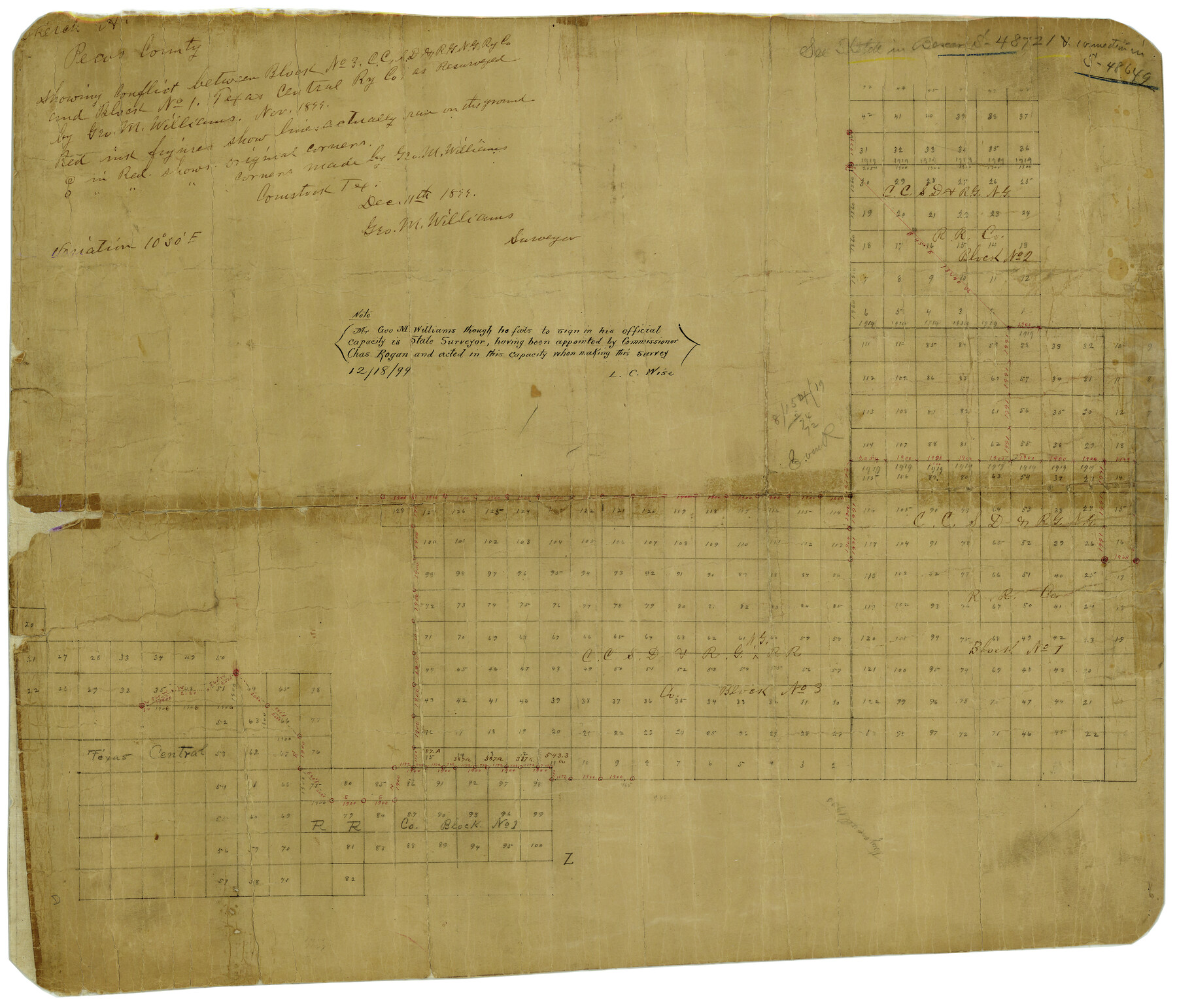
Pecos County Rolled Sketch 26
[Sketch showing conflict between Block 3, C. C. S. D. & R. G. N. G. Ry. Co. and Block 1, Texas Central Ry. Co.]
-
Map/Doc
7211
-
Collection
General Map Collection
-
Object Dates
12/11/1899 (Creation Date)
-
People and Organizations
Geo. M. Williams (Surveyor/Engineer)
-
Counties
Pecos Terrell
-
Subjects
Surveying Rolled Sketch
-
Height x Width
19.9 x 23.6 inches
50.6 x 59.9 cm
-
Medium
paper, manuscript
Related maps
Terrell County Sketch File 6

Print $28.00
- Digital $50.00
Terrell County Sketch File 6
1899
Size 13.0 x 8.5 inches
Map/Doc 37888
Part of: General Map Collection
Cooke County Working Sketch 29

Print $20.00
- Digital $50.00
Cooke County Working Sketch 29
1977
Size 28.7 x 35.0 inches
Map/Doc 68266
Dickens County Sketch File 6a

Print $6.00
- Digital $50.00
Dickens County Sketch File 6a
1882
Size 16.5 x 9.4 inches
Map/Doc 20969

Flight Mission No. DAG-23K, Frame 151, Matagorda County

Print $20.00
- Digital $50.00
Flight Mission No. DAG-23K, Frame 151, Matagorda County
1953
Size 15.9 x 15.8 inches
Map/Doc 86499
Right-of-Way Map Seawall Extension Galveston Island

Print $40.00
- Digital $50.00
Right-of-Way Map Seawall Extension Galveston Island
1958
Size 16.4 x 62.8 inches
Map/Doc 73617
Lamb County Working Sketch 4

Print $40.00
- Digital $50.00
Lamb County Working Sketch 4
1984
Size 42.9 x 58.0 inches
Map/Doc 70277
Bexar County Rolled Sketch 6

Print $40.00
- Digital $50.00
Bexar County Rolled Sketch 6
Size 36.6 x 54.9 inches
Map/Doc 81902
Flight Mission No. CRC-2R, Frame 200, Chambers County

Print $20.00
- Digital $50.00
Flight Mission No. CRC-2R, Frame 200, Chambers County
1956
Size 18.8 x 22.4 inches
Map/Doc 84778

Madison County Working Sketch Graphic Index

Print $20.00
- Digital $50.00
Madison County Working Sketch Graphic Index
1922
Size 29.4 x 47.6 inches
Map/Doc 76628
Crosby County Working Sketch 4

Print $20.00
- Digital $50.00
Crosby County Working Sketch 4
1907
Size 19.9 x 14.0 inches
Map/Doc 68438
Wharton County Rolled Sketch 8

Print $20.00
- Digital $50.00
Wharton County Rolled Sketch 8
Size 24.4 x 39.2 inches
Map/Doc 8232
You may also like
Flight Mission No. DAH-9M, Frame 157, Orange County

Print $20.00
- Digital $50.00
Flight Mission No. DAH-9M, Frame 157, Orange County
1953
Size 18.5 x 22.5 inches
Map/Doc 86856
Flight Mission No. DQN-7K, Frame 30, Calhoun County

Print $20.00
- Digital $50.00
Flight Mission No. DQN-7K, Frame 30, Calhoun County
1953
Size 18.6 x 22.1 inches
Map/Doc 84468
Crosby County Sketch File 14a

Print $40.00
- Digital $50.00
Crosby County Sketch File 14a
Size 18.9 x 20.5 inches
Map/Doc 11249
Brewster County Sketch File B-1

Print $6.00
- Digital $50.00
Brewster County Sketch File B-1
1910
Size 14.2 x 8.8 inches
Map/Doc 15716
Wilbarger County Working Sketch 13

Print $20.00
- Digital $50.00
Wilbarger County Working Sketch 13
1954
Size 25.9 x 24.0 inches
Map/Doc 72551
Flight Mission No. CGI-4N, Frame 158, Cameron County

Print $20.00
- Digital $50.00
Flight Mission No. CGI-4N, Frame 158, Cameron County
1955
Size 18.5 x 22.2 inches
Map/Doc 84666
Morris County Rolled Sketch 2A

Print $20.00
- Digital $50.00
Morris County Rolled Sketch 2A
Size 24.0 x 18.8 inches
Map/Doc 10228
Flight Mission No. CRC-4R, Frame 108, Chambers County

Print $20.00
- Digital $50.00
Flight Mission No. CRC-4R, Frame 108, Chambers County
1956
Size 18.7 x 22.4 inches
Map/Doc 84905
Duval County Sketch File 47

Print $6.00
- Digital $50.00
Duval County Sketch File 47
Size 11.5 x 8.8 inches
Map/Doc 21402
Kaufman County Sketch File 17 1/2

Print $6.00
- Digital $50.00
Kaufman County Sketch File 17 1/2
1888
Size 17.0 x 11.1 inches
Map/Doc 28659
Flight Mission No. CGI-1N, Frame 215, Cameron County

Print $20.00
- Digital $50.00
Flight Mission No. CGI-1N, Frame 215, Cameron County
1955
Size 18.5 x 22.1 inches
Map/Doc 84524
Mills County Boundary File 5

Print $8.00
- Digital $50.00
Mills County Boundary File 5
Size 14.2 x 8.7 inches
Map/Doc 57296