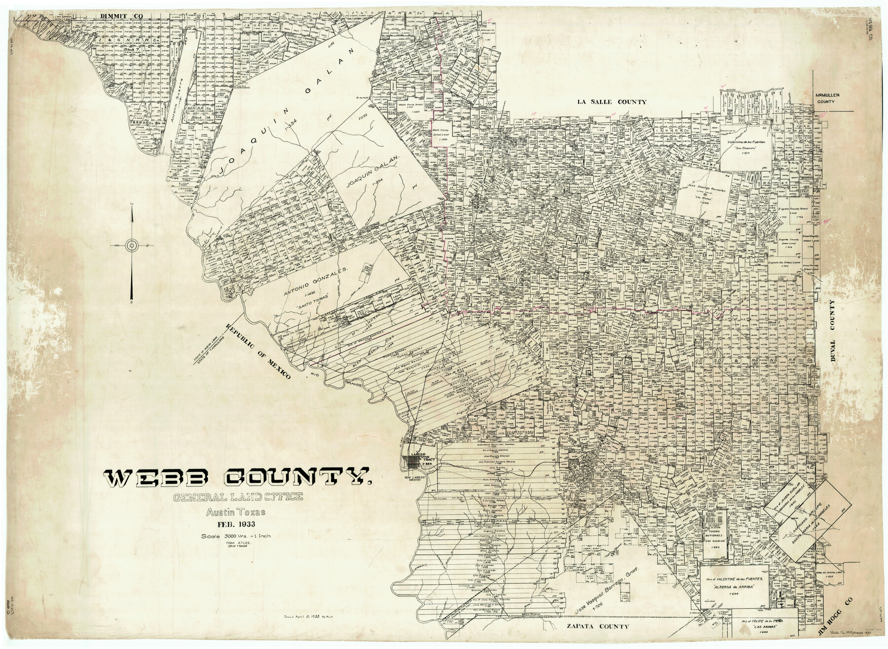
Webb County
-
Map/Doc
63116
-
Collection
General Map Collection
-
Object Dates
2/1933 (Creation Date)
-
People and Organizations
Tom G. Atlee (Draftsman)
-
Counties
Webb
-
Subjects
County
-
Height x Width
44.3 x 60.7 inches
112.5 x 154.2 cm
-
Comments
Traced April 8, 1933 by Beck.
Part of: General Map Collection
Coleman County Sketch File 25

Print $40.00
- Digital $50.00
Coleman County Sketch File 25
1872
Size 12.5 x 15.8 inches
Map/Doc 18710
Presidio County Sketch File 5

Print $4.00
- Digital $50.00
Presidio County Sketch File 5
1872
Size 12.9 x 8.2 inches
Map/Doc 34433
Eastland County Working Sketch 54

Print $20.00
- Digital $50.00
Eastland County Working Sketch 54
1984
Size 19.6 x 18.0 inches
Map/Doc 68835
San Saba County Sketch File 18

Print $12.00
- Digital $50.00
San Saba County Sketch File 18
1919
Size 11.4 x 8.8 inches
Map/Doc 36460
Flight Mission No. DQN-2K, Frame 42, Calhoun County

Print $20.00
- Digital $50.00
Flight Mission No. DQN-2K, Frame 42, Calhoun County
1953
Size 18.5 x 22.2 inches
Map/Doc 84247
Bandera County Rolled Sketch 2

Print $20.00
- Digital $50.00
Bandera County Rolled Sketch 2
1945
Size 19.1 x 24.0 inches
Map/Doc 5114
Flight Mission No. BRA-7M, Frame 150, Jefferson County

Print $20.00
- Digital $50.00
Flight Mission No. BRA-7M, Frame 150, Jefferson County
1953
Size 18.7 x 22.4 inches
Map/Doc 85544
Mills County Working Sketch 25

Print $20.00
- Digital $50.00
Mills County Working Sketch 25
1988
Size 22.0 x 25.1 inches
Map/Doc 71055
Drainage Basins of Texas Streams

Print $20.00
- Digital $50.00
Drainage Basins of Texas Streams
Size 35.3 x 42.0 inches
Map/Doc 65270
Map Location of the Pecos & Northern Texas Railway from [illegible] through Deaf Smith County
![64180, Map Location of the Pecos & Northern Texas Railway from [illegible] through Deaf Smith County, General Map Collection](https://historictexasmaps.com/wmedia_w700/maps/64180-1.tif.jpg)
Print $40.00
- Digital $50.00
Map Location of the Pecos & Northern Texas Railway from [illegible] through Deaf Smith County
Size 16.3 x 71.8 inches
Map/Doc 64180
Clay County Sketch File 7

Print $2.00
- Digital $50.00
Clay County Sketch File 7
Size 8.2 x 3.5 inches
Map/Doc 18397
Map of Cottle County

Print $20.00
- Digital $50.00
Map of Cottle County
1893
Size 23.1 x 19.4 inches
Map/Doc 3451
You may also like
[Block 1 and vicinity]
![90703, [Block 1 and vicinity], Twichell Survey Records](https://historictexasmaps.com/wmedia_w700/maps/90703-1.tif.jpg)
Print $20.00
- Digital $50.00
[Block 1 and vicinity]
Size 25.3 x 24.1 inches
Map/Doc 90703
Tom Green County Sketch File 63

Print $20.00
- Digital $50.00
Tom Green County Sketch File 63
1890
Size 31.8 x 17.9 inches
Map/Doc 12445
Sketch showing Mineral Leases in Nueces Bay

Print $20.00
- Digital $50.00
Sketch showing Mineral Leases in Nueces Bay
1942
Size 14.3 x 24.3 inches
Map/Doc 3019

Mitchell County, Texas

Print $20.00
- Digital $50.00
Mitchell County, Texas
1870
Size 22.7 x 18.0 inches
Map/Doc 741
Val Verde County Working Sketch 33

Print $20.00
- Digital $50.00
Val Verde County Working Sketch 33
1938
Size 24.4 x 30.7 inches
Map/Doc 72168
General Highway Map. Detail of Cities and Towns in Dallas County, Texas [Dallas and vicinity]
![79433, General Highway Map. Detail of Cities and Towns in Dallas County, Texas [Dallas and vicinity], Texas State Library and Archives](https://historictexasmaps.com/wmedia_w700/maps/79433.tif.jpg)
Print $20.00
General Highway Map. Detail of Cities and Towns in Dallas County, Texas [Dallas and vicinity]
1961
Size 18.1 x 24.5 inches
Map/Doc 79433
Gillespie County

Print $40.00
- Digital $50.00
Gillespie County
1887
Size 34.6 x 49.8 inches
Map/Doc 66836
Sulphur River, Bassett Sheet

Print $20.00
- Digital $50.00
Sulphur River, Bassett Sheet
1939
Size 24.8 x 32.0 inches
Map/Doc 78322
Map of Columbia and Wharton Division, HT&BRRCo., Texas

Print $20.00
- Digital $50.00
Map of Columbia and Wharton Division, HT&BRRCo., Texas
1860
Size 33.5 x 23.9 inches
Map/Doc 64415
Dimmit County Sketch File 41

Print $4.00
- Digital $50.00
Dimmit County Sketch File 41
1901
Size 14.6 x 9.1 inches
Map/Doc 21169
Brooks County Working Sketch 7

Print $20.00
- Digital $50.00
Brooks County Working Sketch 7
1928
Size 35.6 x 27.1 inches
Map/Doc 67791