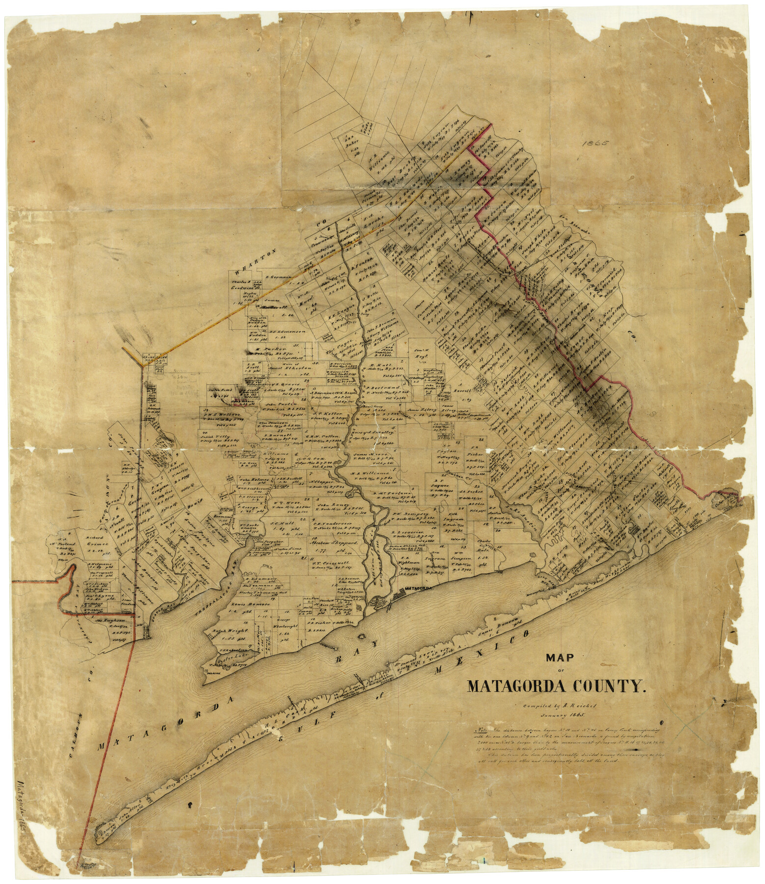
Map of Matagorda County
-
Map/Doc
3843
-
Collection
General Map Collection
-
Object Dates
1/1865 (Creation Date)
-
People and Organizations
Robert Reichel (Compiler)
-
Counties
Matagorda
-
Subjects
County
-
Height x Width
32.8 x 28.4 inches
83.3 x 72.1 cm
-
Features
Cane Lake
Carancahua Bay
Reed Creek
Trespalacios Bay
Troy Creek
Fug[ ]r's Bayou
Horn Creek
Matagorda
Little Boggy Creek
Big Boggy Creek
Live Oak Bay
Blue Creek
Peace Slough
Cedar Lake
Dog Island
East Carancahua Creek
Cane Bayou
Oyster Lake
Austin
Turtle Bay
Matagorda Bay
Palacios
Cotton Bayou
Long Bayou
McFarland Bayou
Port Cavallo
Gulf of Mexico
Port Cavallo
Pelican Island
Buck Bayou
Len's Bayou
HT&B
San Bernardo [River]
Linville Bayou
Bluff Creek
Jennings Creek
Trespalacios Creek
Long Point Creek
Colorado River
Dressing Point
Elliot's Ferry
Snow's Ferry
Caney Bayou
Jones Creek
Cottonwood Creek
Juanito Creek
Wilson's Creek
Postoak Creek
Prairie Creek
Live Oak Bayou
Cedar Lake Creek
Lake Austin
Canoe Bayou
Live Oak Creek
Piney Branch [of Colorado River]
Cush Creek
Turtle Creek
Part of: General Map Collection
Flight Mission No. DQN-7K, Frame 91, Calhoun County

Print $20.00
- Digital $50.00
Flight Mission No. DQN-7K, Frame 91, Calhoun County
1953
Size 18.4 x 22.2 inches
Map/Doc 84482
Hays County Working Sketch 13

Print $20.00
- Digital $50.00
Hays County Working Sketch 13
1952
Size 24.2 x 35.0 inches
Map/Doc 66087
Houston County Working Sketch Graphic Index

Print $40.00
- Digital $50.00
Houston County Working Sketch Graphic Index
1944
Size 48.1 x 42.7 inches
Map/Doc 76582
Potter County Sketch File 22

Print $30.00
- Digital $50.00
Potter County Sketch File 22
1962
Size 14.2 x 8.6 inches
Map/Doc 34415
Comal County Working Sketch 6

Print $20.00
- Digital $50.00
Comal County Working Sketch 6
1950
Size 25.1 x 24.2 inches
Map/Doc 68172
Burleson County Working Sketch 47

Print $20.00
- Digital $50.00
Burleson County Working Sketch 47
2010
Size 23.2 x 28.1 inches
Map/Doc 89620
Jeff Davis County Rolled Sketch 9

Print $20.00
- Digital $50.00
Jeff Davis County Rolled Sketch 9
Size 18.3 x 22.9 inches
Map/Doc 6362
Garza County Sketch File C2

Print $6.00
- Digital $50.00
Garza County Sketch File C2
1900
Size 10.3 x 8.4 inches
Map/Doc 24019
Flight Mission No. CRC-2R, Frame 54, Chambers County

Print $20.00
- Digital $50.00
Flight Mission No. CRC-2R, Frame 54, Chambers County
1956
Size 18.5 x 22.3 inches
Map/Doc 84727
Stephens County Working Sketch 26

Print $20.00
- Digital $50.00
Stephens County Working Sketch 26
1976
Size 36.9 x 32.2 inches
Map/Doc 63969
Palo Pinto County Sketch File 24

Print $20.00
- Digital $50.00
Palo Pinto County Sketch File 24
Size 21.0 x 32.8 inches
Map/Doc 12136
Montague County Working Sketch 21

Print $20.00
- Digital $50.00
Montague County Working Sketch 21
1952
Size 33.1 x 39.5 inches
Map/Doc 71087
You may also like
Uvalde County Sketch File 15a

Print $20.00
- Digital $50.00
Uvalde County Sketch File 15a
1890
Size 13.2 x 16.7 inches
Map/Doc 12530
Kaufman County Sketch File 19

Print $30.00
- Digital $50.00
Kaufman County Sketch File 19
1922
Size 11.2 x 8.7 inches
Map/Doc 28666
Map of Upton County

Print $20.00
- Digital $50.00
Map of Upton County
1899
Size 46.0 x 40.2 inches
Map/Doc 63087
Austin County Sketch File 6a

Print $14.00
- Digital $50.00
Austin County Sketch File 6a
1895
Size 11.2 x 8.6 inches
Map/Doc 13865
Kerr County Rolled Sketch 15

Print $20.00
- Digital $50.00
Kerr County Rolled Sketch 15
1951
Size 14.8 x 20.8 inches
Map/Doc 7720
Johnson's Texas

Print $20.00
- Digital $50.00
Johnson's Texas
1866
Size 18.4 x 27.2 inches
Map/Doc 89279
Geographical Observations on the Inner Margins of the Border and Coastal Reserves of Texas, 1824-1836

Geographical Observations on the Inner Margins of the Border and Coastal Reserves of Texas, 1824-1836
2022
Map/Doc 97131
Waller County

Print $20.00
- Digital $50.00
Waller County
1897
Size 46.0 x 30.2 inches
Map/Doc 63107
Galveston County NRC Article 33.136 Sketch 64

Print $26.00
- Digital $50.00
Galveston County NRC Article 33.136 Sketch 64
2010
Size 24.0 x 36.0 inches
Map/Doc 89990
McCulloch County Sketch File 9

Print $6.00
- Digital $50.00
McCulloch County Sketch File 9
1883
Size 7.3 x 8.7 inches
Map/Doc 31184
Smith County Working Sketch 8

Print $20.00
- Digital $50.00
Smith County Working Sketch 8
1941
Size 28.9 x 22.7 inches
Map/Doc 63893
Real County Working Sketch 52

Print $20.00
- Digital $50.00
Real County Working Sketch 52
1958
Size 36.2 x 38.6 inches
Map/Doc 71944