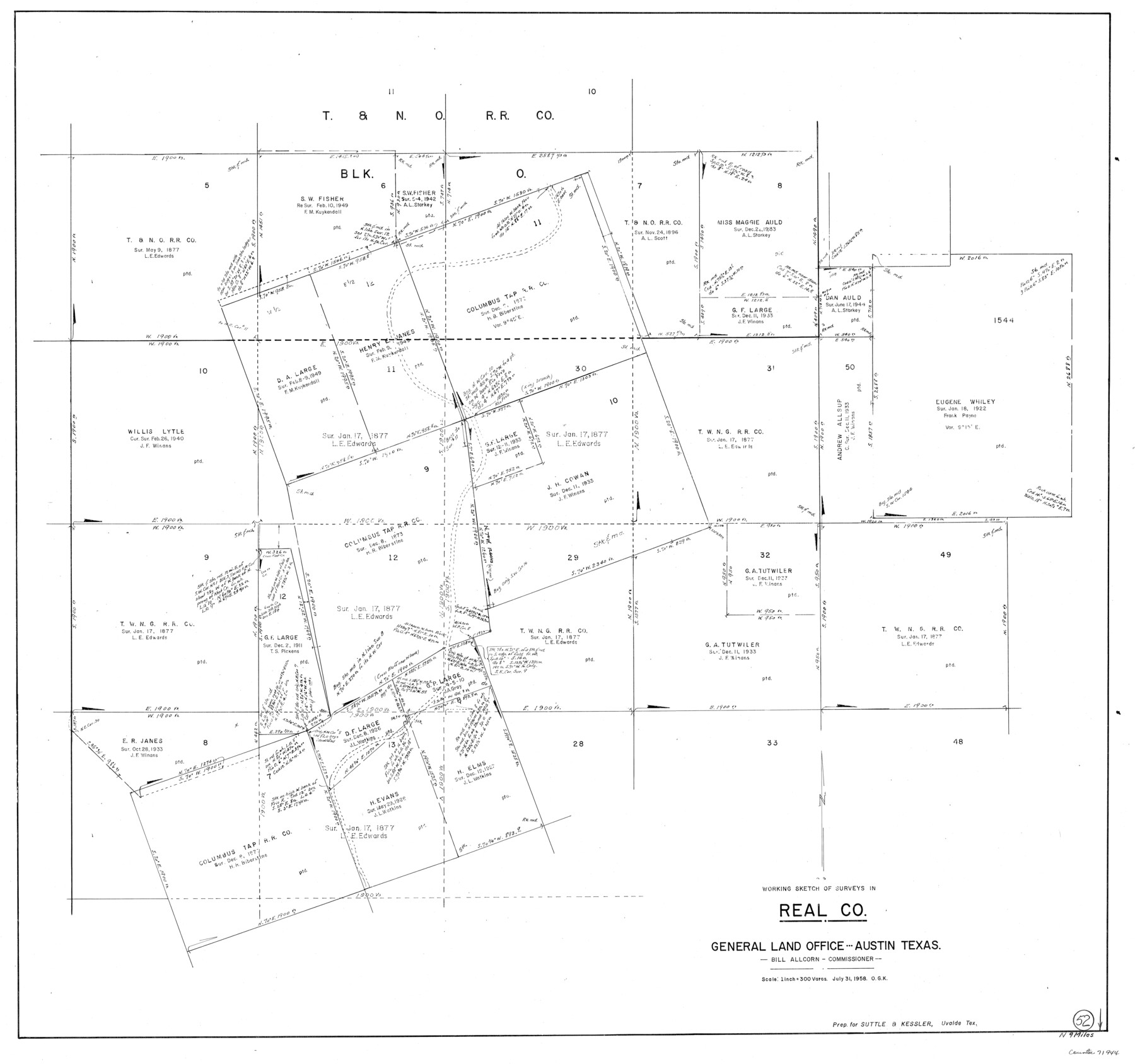
Real County Working Sketch 52
-
Map/Doc
71944
-
Collection
General Map Collection
-
Object Dates
7/31/1958 (Creation Date)
-
People and Organizations
Otto G. Kurio (Draftsman)
-
Counties
Real
-
Subjects
Surveying Working Sketch
-
Height x Width
36.2 x 38.6 inches
92.0 x 98.0 cm
-
Scale
1" = 300 varas
Part of: General Map Collection
Live Oak County Working Sketch 2

Print $20.00
- Digital $50.00
Live Oak County Working Sketch 2
1891
Size 17.9 x 18.2 inches
Map/Doc 70587
Flight Mission No. BQY-4M, Frame 34, Harris County

Print $20.00
- Digital $50.00
Flight Mission No. BQY-4M, Frame 34, Harris County
1953
Size 18.6 x 22.4 inches
Map/Doc 85249
Houston County Sketch File 7

Print $6.00
- Digital $50.00
Houston County Sketch File 7
1861
Size 12.0 x 11.1 inches
Map/Doc 26764
San Jacinto County Rolled Sketch 15

Print $20.00
- Digital $50.00
San Jacinto County Rolled Sketch 15
2001
Size 19.2 x 25.2 inches
Map/Doc 7571
Flight Mission No. CGI-1N, Frame 172, Cameron County

Print $20.00
- Digital $50.00
Flight Mission No. CGI-1N, Frame 172, Cameron County
1955
Size 18.5 x 22.2 inches
Map/Doc 84507
Reconnaissance of the Coast of Texas between Matagorda and Corpus Christi Bays

Print $20.00
- Digital $50.00
Reconnaissance of the Coast of Texas between Matagorda and Corpus Christi Bays
1858
Size 25.2 x 21.4 inches
Map/Doc 75987
Culberson County Sketch File D

Print $32.00
- Digital $50.00
Culberson County Sketch File D
1915
Size 7.4 x 8.8 inches
Map/Doc 20189
Haskell County

Print $20.00
- Digital $50.00
Haskell County
1933
Size 44.9 x 37.9 inches
Map/Doc 73175
Montgomery County Working Sketch 7

Print $20.00
- Digital $50.00
Montgomery County Working Sketch 7
1932
Size 36.6 x 26.2 inches
Map/Doc 71113
Bandera County Working Sketch 19

Print $20.00
- Digital $50.00
Bandera County Working Sketch 19
1946
Size 43.3 x 35.8 inches
Map/Doc 67615
Young County Rolled Sketch 9

Print $20.00
- Digital $50.00
Young County Rolled Sketch 9
1921
Size 24.0 x 22.6 inches
Map/Doc 8297
Flight Mission No. CRC-3R, Frame 106, Chambers County

Print $20.00
- Digital $50.00
Flight Mission No. CRC-3R, Frame 106, Chambers County
1956
Size 18.8 x 22.6 inches
Map/Doc 84844
You may also like
Galveston County NRC Article 33.136 Sketch 39

Print $24.00
- Digital $50.00
Galveston County NRC Article 33.136 Sketch 39
2005
Size 25.0 x 25.4 inches
Map/Doc 83084
Parker County Sketch File 10

Print $40.00
- Digital $50.00
Parker County Sketch File 10
Size 43.5 x 37.8 inches
Map/Doc 10567
Cass County Working Sketch 48

Print $20.00
- Digital $50.00
Cass County Working Sketch 48
1992
Size 21.3 x 36.4 inches
Map/Doc 67951
Motley County Sketch File 31 (S)

Print $4.00
- Digital $50.00
Motley County Sketch File 31 (S)
1913
Size 14.4 x 6.7 inches
Map/Doc 32213
The Scarborough Company's New Railroad, Post Office & County Map of Texas, Oklahoma and Indian Territory Compiled from the Latest Government Surveys and Original Sources

Print $20.00
- Digital $50.00
The Scarborough Company's New Railroad, Post Office & County Map of Texas, Oklahoma and Indian Territory Compiled from the Latest Government Surveys and Original Sources
1904
Size 42.8 x 46.6 inches
Map/Doc 93911
The Oil and Gas Journal's Oil Map of Texas

Print $20.00
- Digital $50.00
The Oil and Gas Journal's Oil Map of Texas
1938
Size 38.3 x 39.4 inches
Map/Doc 96970
Morris County Working Sketch 3

Print $20.00
- Digital $50.00
Morris County Working Sketch 3
1958
Size 27.6 x 38.2 inches
Map/Doc 71202
Index for Texas Railroad ROW & track maps available on microfilm at THD & Archives and Records

Print $2.00
- Digital $50.00
Index for Texas Railroad ROW & track maps available on microfilm at THD & Archives and Records
1977
Size 11.1 x 8.9 inches
Map/Doc 60755
Kenedy County Rolled Sketch 6

Print $20.00
- Digital $50.00
Kenedy County Rolled Sketch 6
1911
Size 28.5 x 25.4 inches
Map/Doc 6463
Martin County Boundary File 2a

Print $6.00
- Digital $50.00
Martin County Boundary File 2a
Size 14.1 x 8.8 inches
Map/Doc 56776
Flight Mission No. CRC-2R, Frame 3, Chambers County

Print $20.00
- Digital $50.00
Flight Mission No. CRC-2R, Frame 3, Chambers County
1956
Size 18.8 x 22.5 inches
Map/Doc 84722
General Highway Map, Harris County, Texas

Print $20.00
General Highway Map, Harris County, Texas
1961
Size 24.7 x 18.0 inches
Map/Doc 79501