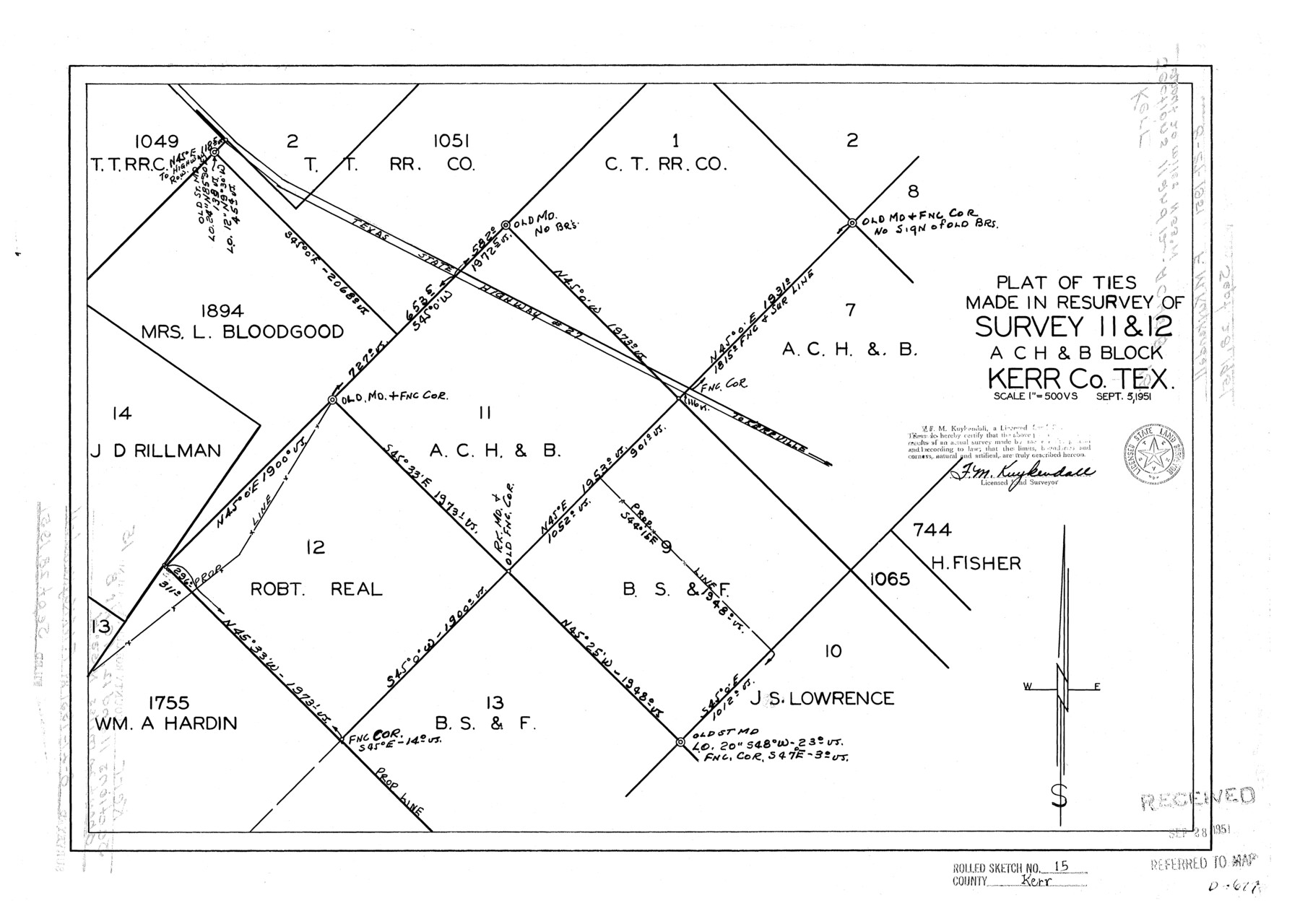
Kerr County Rolled Sketch 15
Plat of ties made in resurvey of survey 11 & 12, A. C. H. & B. Block, Kerr Co., Tex.
-
Map/Doc
7720
-
Collection
General Map Collection
-
Object Dates
1951/9/5 (Creation Date)
1951/9/28 (File Date)
-
People and Organizations
F.M. Kuykendall (Surveyor/Engineer)
-
Counties
Kerr
-
Subjects
Surveying Rolled Sketch
-
Height x Width
14.8 x 20.8 inches
37.6 x 52.8 cm
-
Scale
1" = 500 varas
Part of: General Map Collection
Mason County Working Sketch 10

Print $40.00
- Digital $50.00
Mason County Working Sketch 10
1949
Size 42.4 x 49.7 inches
Map/Doc 70846
Wichita Falls, Wichita County, Texas

Print $20.00
- Digital $50.00
Wichita Falls, Wichita County, Texas
Size 32.0 x 22.6 inches
Map/Doc 96791
Frio County Sketch File 20

Print $6.00
- Digital $50.00
Frio County Sketch File 20
1964
Size 14.2 x 8.8 inches
Map/Doc 23159
Amistad International Reservoir on Rio Grande 101

Print $20.00
- Digital $50.00
Amistad International Reservoir on Rio Grande 101
1950
Size 28.5 x 40.9 inches
Map/Doc 75532
Calhoun County Rolled Sketch 29B

Print $20.00
- Digital $50.00
Calhoun County Rolled Sketch 29B
Size 43.4 x 45.0 inches
Map/Doc 8558
Hale County Working Sketch 5

Print $20.00
- Digital $50.00
Hale County Working Sketch 5
1980
Size 15.0 x 11.1 inches
Map/Doc 63325
Aransas County NRC Article 33.136 Sketch 22

Print $24.00
Aransas County NRC Article 33.136 Sketch 22
2023
Map/Doc 97270
Edwards County Working Sketch 64

Print $20.00
- Digital $50.00
Edwards County Working Sketch 64
1956
Size 20.9 x 16.3 inches
Map/Doc 68940
Brown County Working Sketch 2

Print $20.00
- Digital $50.00
Brown County Working Sketch 2
1919
Size 17.0 x 17.5 inches
Map/Doc 67767
Hunt County Sketch File 49

Print $4.00
- Digital $50.00
Hunt County Sketch File 49
1852
Size 7.3 x 8.9 inches
Map/Doc 27168
Goliad County Working Sketch 23

Print $20.00
- Digital $50.00
Goliad County Working Sketch 23
1979
Size 26.8 x 32.9 inches
Map/Doc 63213
Amistad International Reservoir on Rio Grande 67

Print $20.00
- Digital $50.00
Amistad International Reservoir on Rio Grande 67
1949
Size 28.3 x 39.5 inches
Map/Doc 73352
You may also like
Sabine County Sketch File 5

Print $8.00
Sabine County Sketch File 5
1876
Size 12.9 x 8.5 inches
Map/Doc 35608
[Survey 321, Double Lakes Area Northwest of Tohoka]
![91347, [Survey 321, Double Lakes Area Northwest of Tohoka], Twichell Survey Records](https://historictexasmaps.com/wmedia_w700/maps/91347-1.tif.jpg)
Print $20.00
- Digital $50.00
[Survey 321, Double Lakes Area Northwest of Tohoka]
Size 35.0 x 32.2 inches
Map/Doc 91347
DeWitt County Working Sketch 4

Print $20.00
- Digital $50.00
DeWitt County Working Sketch 4
1963
Size 37.0 x 45.6 inches
Map/Doc 68594
Upton County Working Sketch 16

Print $20.00
- Digital $50.00
Upton County Working Sketch 16
1941
Size 17.1 x 12.0 inches
Map/Doc 69512
Wood County Working Sketch 4

Print $20.00
- Digital $50.00
Wood County Working Sketch 4
1941
Size 21.0 x 28.3 inches
Map/Doc 62004
Crockett County Working Sketch 20

Print $20.00
- Digital $50.00
Crockett County Working Sketch 20
1920
Size 43.7 x 27.6 inches
Map/Doc 68353
Flight Mission No. BRA-8M, Frame 70, Jefferson County

Print $20.00
- Digital $50.00
Flight Mission No. BRA-8M, Frame 70, Jefferson County
1953
Size 18.6 x 22.3 inches
Map/Doc 85590
Live Oak County Working Sketch 21

Print $20.00
- Digital $50.00
Live Oak County Working Sketch 21
1964
Size 30.8 x 33.9 inches
Map/Doc 70606
Upton County Working Sketch 21

Print $20.00
- Digital $50.00
Upton County Working Sketch 21
1950
Size 33.8 x 36.0 inches
Map/Doc 69517
Map of Jasper County

Print $40.00
- Digital $50.00
Map of Jasper County
1898
Size 49.1 x 39.6 inches
Map/Doc 66879
Flight Mission No. CRC-4R, Frame 66, Chambers County

Print $20.00
- Digital $50.00
Flight Mission No. CRC-4R, Frame 66, Chambers County
1956
Size 18.6 x 22.5 inches
Map/Doc 84870
Flight Mission No. DAG-23K, Frame 148, Matagorda County

Print $20.00
- Digital $50.00
Flight Mission No. DAG-23K, Frame 148, Matagorda County
1953
Size 18.6 x 22.4 inches
Map/Doc 86496